
Magnitude |
:3.3 |
| Date & Time (UTC) | 2010-08-06 20:08:31.5 |
| Date & Time (Local) | 1389/5/16 00:38:31.5 |
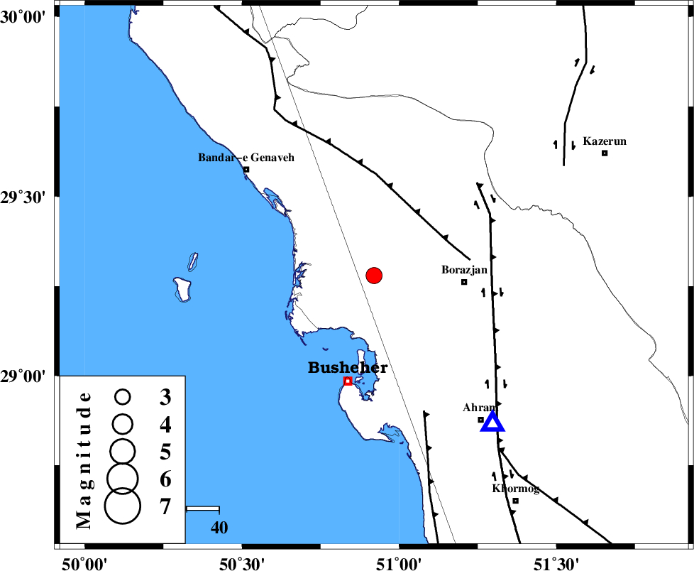
| Location | Lat:29.28 Lon: 50.92 |
| Region | Bushehr Province, 28 km West of Borazjan |
Nearest Cities |
|
| 1 km North of Kareband, Bushehr Province | |
| 4 km of Shabankareh, Bushehr Province | |
| 15 km West of Ziyarat, Bushehr Province | |
| 23 km West of Saedabad, Bushehr Province | |
| 23 km South of Dehkohneh, Bushehr Province | |
| Depth | 40 km |
| Agency | |
Faults within 150 km: |
|
| ZFF3 (Length: 125 km) , Distance to epicenter: 24 km | |
| BORAZJAN_F (Length: 168 km) , Distance to epicenter: 36 km | |
| ZFF2 (Length: 84 km) , Distance to epicenter: 45 km | |
| Number of Phases | 11 |
| RMS | 0.3 |
| Number of Stations | 9 |
| Error in Latitude | >8 km |
| Error in Longitude | 8.3 km |
| Error in Depth | 7.3 km |
Download waveform in seisan format
to download seisan software Click here
to access information about IIEES stations Click here
Amplitude | ||||||||
| UID | Agency | Station | Component | Amplitude | Period | Arrival Time | Proccessing Time | Signal Clip |
| 67970 | IIEES | GHIR | E | 185.9 | 0.48 | 2010-08-06 20:09:46 | 2010-08-06 08:28:00 | n |
| 67971 | IIEES | GHIR | N | 160.1 | 0.52 | 2010-08-06 20:09:52 | 2010-08-06 08:28:00 | n |
| 67972 | IIEES | KRBR | E | 18.3 | 0.44 | 2010-08-06 20:10:57 | 2010-08-06 08:28:00 | n |
| 67973 | IIEES | KRBR | N | 18 | 0.48 | 2010-08-06 20:11:09 | 2010-08-06 08:28:00 | n |
Phase | ||||||||||||
| Agency | Station | Component | Phase Type | Phase Quality | First Motion | Observed Arrival Time | Time Residual | Loc. Flag | Input Weight | Distance | Azimuth | |
| IIEES | AHRM | Z | Pg | E | 2010-08-06 20:08:42 | -0.6 | y | 58.9 | 141 | |||
| IIEES | AHRM | N | Sg | E | 2010-08-06 20:08:51 | 0.5 | y | 58.9 | 141 | |||
| IIEES | GHIR | N | Pn | E | 2010-08-06 20:09:05 | 0 | y | 230 | 118 | |||
| IIEES | GHIR | N | Sg | E | 2010-08-06 20:09:35 | -0.1 | y | 230 | 118 | |||
| IIEES | NASN | Z | Pn | E | 2010-08-06 20:09:30 | 0.1 | y | 430 | 24 | |||
| IIEES | KHMZ | N | Pn | E | 2010-08-06 20:09:39 | -0.3 | y | 503 | 350 | |||
| IIEES | KRBR | Z | Pn | E | 2010-08-06 20:09:47 | -0.1 | y | 571 | 81 | |||
| IIEES | GHVR | E | Pn | E | 2010-08-06 20:09:48 | 0.1 | y | 578 | 3 | |||
| IIEES | ASAO | Z | Pn | E | 2010-08-06 20:09:50 | 0.5 | y | 590 | 352 | |||
| IIEES | DAMV | Z | Pn | E | 2010-08-06 20:10:05 | -0.3 | y | 711 | 8 | |||
| IIEES | SNGE | Z | Pn | E | 2010-08-06 20:10:07 | 0.2 | y | 727 | 333 | |||