
Magnitude |
:3.4 |
| Date & Time (UTC) | 2007-01-07 15:57:33.4 |
| Date & Time (Local) | 1385/10/17 19:27:33.4 |
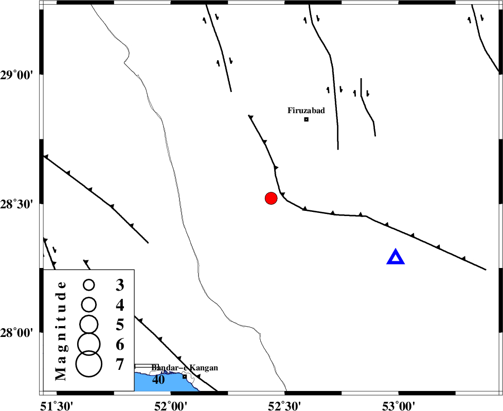
| Location | Lat:28.52 Lon: 52.44 |
| Region | 37 km South-West of Firuz Abad, Fars Province |
Nearest Cities |
|
| 13 km North East of Dahrom, Fars Province | |
| 27 km North West of Hengam, Fars Province | |
| 33 km South West of Jaydasht, Fars Province | |
| 34 km South of Ahmadabad, Fars Province | |
| 37 km South West of Firuz Abad, Fars Province | |
| Depth | 11 km |
| Agency | |
Faults within 150 km: |
|
| QIR_F (Length: 130 km) , Distance to epicenter: 5 km | |
| SABZ_PUSHAN_F_Z1 (Length: 69 km) , Distance to epicenter: 36 km | |
| KAREBASS_F (Length: 98 km) , Distance to epicenter: 49 km | |
| Number of Phases | 6 |
| RMS | 0.2 |
| Number of Stations | 5 |
| Error in Latitude | >11 km |
| Error in Longitude | 11.2 km |
| Error in Depth | 8.2 km |
Download waveform in seisan format
to download seisan software Click here
to access information about IIEES stations Click here
Amplitude | ||||||||
| UID | Agency | Station | Component | Amplitude | Period | Arrival Time | Proccessing Time | Signal Clip |
| 37238 | IIEES | GHIR | N | 4125.9 | 0.57 | 2007-01-07 15:57:54 | 2007-05-09 05:26:00 | n |
| 37239 | IIEES | GHIR | E | 3911.1 | 0.41 | 2007-01-07 15:57:55 | 2007-05-09 05:26:00 | n |
| 37240 | IIEES | BNDS | N | 70.8 | 0.53 | 2007-01-07 15:59:37 | 2007-05-09 05:26:00 | n |
| 37241 | IIEES | BNDS | E | 74.8 | 0.39 | 2007-01-07 15:59:43 | 2007-05-09 05:26:00 | n |
| 37242 | IIEES | KRBR | N | 35.7 | 0.59 | 2007-01-07 16:00:06 | 2007-05-09 05:26:00 | n |
| 37243 | IIEES | ASAO | N | 8.3 | 0.93 | 2007-01-07 16:00:36 | 2007-05-09 05:26:00 | n |
Phase | ||||||||||||
| Agency | Station | Component | Phase Type | Phase Quality | First Motion | Observed Arrival Time | Time Residual | Loc. Flag | Input Weight | Distance | Azimuth | |
| IIEES | GHIR | Z | Pg | E | 2007-01-07 15:57:44 | 0.2 | y | 59.7 | 115 | |||
| IIEES | GHIR | E | Sg | E | 2007-01-07 15:57:51 | -0.2 | y | 59.7 | 115 | |||
| IIEES | BNDS | Z | Pn | E | 2007-01-07 15:58:29 | 0 | y | 388 | 108 | |||
| IIEES | KRBR | Z | Pn | E | 2007-01-07 15:58:37 | 0.2 | y | 451 | 68 | |||
| IIEES | NASN | Z | P | E | 2007-01-07 15:58:40 | 0 | y | 476 | 4 | |||
| IIEES | ASAO | Z | P | E | 2007-01-07 15:59:09 | -0.4 | y | 707 | 342 | |||