
Magnitude |
:2.7 |
| Date & Time (UTC) | 2006-10-20 16:15:42.8 |
| Date & Time (Local) | 1385/7/28 19:45:42.8 |
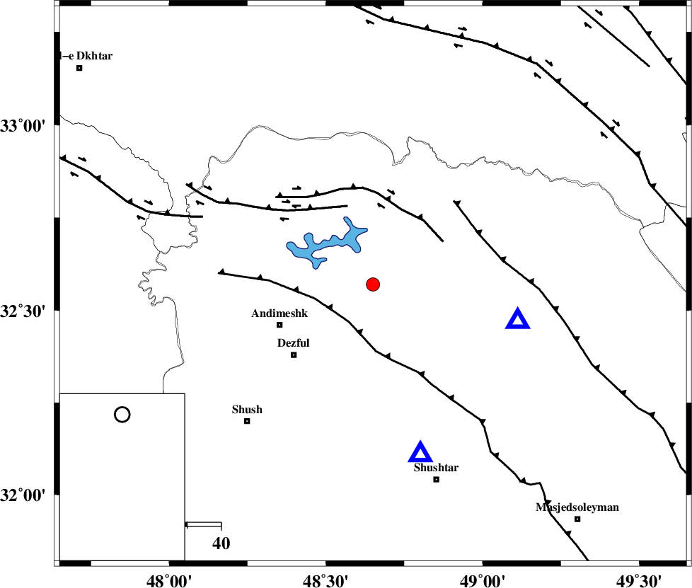
| Location | Lat:32.57 Lon: 48.65 |
| Region | 30 km North-East of Andimeshk, Khoozestan Province |
Nearest Cities |
|
| 19 km North West of Sardasht, Khoozestan Province | |
| 20 km North of Mahur berenji, Khoozestan Province | |
| 29 km South West of Shuy, Khoozestan Province | |
| 31 km North East of Andimeshk, Khoozestan Province | |
| 32 km North East of Dezful, Khoozestan Province | |
| Depth | 14 km |
| Agency | |
Faults within 150 km: |
|
| DEZFUL_EMBAYMENT (Length: 228 km) , Distance to epicenter: 13 km | |
| BALARUD_F_Z2 (Length: 58 km) , Distance to epicenter: 24 km | |
| BALARUD_F_Z3 (Length: 53 km) , Distance to epicenter: 25 km | |
| Number of Phases | 5 |
| RMS | 0.1 |
| Number of Stations | 4 |
| Error in Latitude | >1.8 km |
| Error in Longitude | 4.7 km |
| Error in Depth | 5.2 km |
Download waveform in seisan format
to download seisan software Click here
to access information about IIEES stations Click here
Amplitude | ||||||||
| UID | Agency | Station | Component | Amplitude | Period | Arrival Time | Proccessing Time | Signal Clip |
| 36389 | IIEES | SHGR | E | 640.8 | 0.68 | 2006-10-20 16:16:13 | 2007-01-07 07:24:00 | n |
| 36390 | IIEES | SHGR | N | 764.6 | 0.6 | 2006-10-20 16:16:15 | 2007-01-07 07:24:00 | n |
| 36391 | IIEES | ASAO | N | 31.4 | 0.56 | 2006-10-20 16:17:01 | 2007-01-07 07:24:00 | n |
| 36392 | IIEES | ASAO | E | 35.8 | 0.6 | 2006-10-20 16:17:02 | 2007-01-07 07:24:00 | n |
| 36393 | IIEES | SNGE | N | 27.5 | 0.6 | 2006-10-20 16:17:14 | 2007-01-07 07:24:00 | n |
Phase | ||||||||||||
| Agency | Station | Component | Phase Type | Phase Quality | First Motion | Observed Arrival Time | Time Residual | Loc. Flag | Input Weight | Distance | Azimuth | |
| IIEES | SHGR | Z | PG | E | 2006-10-20 16:15:52 | 0 | y | 52.8 | 165 | |||
| IIEES | ASAO | Z | PN | E | 2006-10-20 16:16:22 | 0.2 | y | 254 | 30 | |||
| IIEES | ASAO | N | SG | E | 2006-10-20 16:16:54 | 0 | y | 254 | 30 | |||
| IIEES | SNGE | Z | PN | E | 2006-10-20 16:16:28 | -0.1 | y | 305 | 337 | |||
| IIEES | NASN | Z | Pn | E | 2006-10-20 16:16:39 | -0.1 | y | 391 | 85 | |||