
Magnitude |
:3.2 |
| Date & Time (UTC) | 2006-10-16 03:49:34.7 |
| Date & Time (Local) | 1385/7/24 07:19:34.7 |
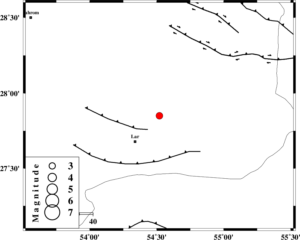
| Location | Lat:27.85 Lon: 54.52 |
| Region | 25 km North-East of Lar, Fars Province |
Nearest Cities |
|
| 10 km of Dehkuyeh, Fars Province | |
| 22 km North East of Latifi, Fars Province | |
| 26 km North East of Lar, Fars Province | |
| 41 km North East of Grash, Fars Province | |
| 51 km North East of Avaz, Fars Province | |
| Depth | 14 km |
| Agency | |
Faults within 150 km: |
|
| BERIZ_F (Length: 49 km) , Distance to epicenter: 13 km | |
| LAR_F (Length: 99 km) , Distance to epicenter: 34 km | |
| HZF2 (Length: 437 km) , Distance to epicenter: 62 km | |
| Number of Phases | 7 |
| RMS | 0.2 |
| Number of Stations | 4 |
| Error in Latitude | >3.9 km |
| Error in Longitude | 2.1 km |
| Error in Depth | 8.1 km |
Download waveform in seisan format
to download seisan software Click here
to access information about IIEES stations Click here
Amplitude | ||||||||
| UID | Agency | Station | Component | Amplitude | Period | Arrival Time | Proccessing Time | Signal Clip |
| 36363 | IIEES | BNDS | N | 308.3 | 0.68 | 2006-10-16 03:50:32 | 2007-01-07 07:24:00 | n |
| 36364 | IIEES | BNDS | E | 233 | 0.56 | 2006-10-16 03:50:39 | 2007-01-07 07:24:00 | n |
| 36365 | IIEES | KRBR | N | 109.5 | 0.64 | 2006-10-16 03:51:19 | 2007-01-07 07:24:00 | n |
| 36366 | IIEES | KRBR | E | 71.3 | 0.76 | 2006-10-16 03:51:21 | 2007-01-07 07:24:00 | n |
Phase | ||||||||||||
| Agency | Station | Component | Phase Type | Phase Quality | First Motion | Observed Arrival Time | Time Residual | Loc. Flag | Input Weight | Distance | Azimuth | |
| IIEES | GHIR | Z | PG | E | 2006-10-16 03:50:00 | -0.5 | y | 158 | 288 | |||
| IIEES | GHIR | E | SG | E | 2006-10-16 03:50:20 | 0.3 | y | 158 | 288 | |||
| IIEES | BNDS | Z | PG | E | 2006-10-16 03:50:03 | 0.1 | y | 171 | 107 | |||
| IIEES | BNDS | N | SG | E | 2006-10-16 03:50:23 | -0.1 | y | 171 | 107 | |||
| IIEES | KRBR | Z | PN | E | 2006-10-16 03:50:22 | 0.2 | y | 322 | 42 | |||
| IIEES | KRBR | N | SG | E | 2006-10-16 03:51:05 | -0.1 | y | 322 | 42 | |||
| IIEES | NASN | Z | PN | E | 2006-10-16 03:50:53 | 0 | y | 573 | 344 | |||