
Magnitude |
:3.4 |
| Date & Time (UTC) | 2026-03-17 10:26:47.4 |
| Date & Time (Local) | 1404/12/26 13:56:47.4 |
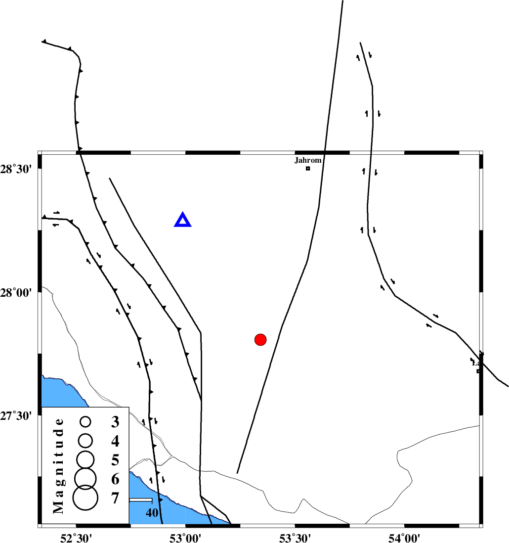
| Location | Lat:27.806 Lon: 53.342 |
| Region | Fars Province, 55 km North-East of Lamerd |
Nearest Cities |
|
| 11 km of Khonj, Fars Province | |
| 30 km North West of Ard, Fars Province | |
| 30 km North West of Fedagh, Fars Province | |
| 34 km North West of Fishur, Fars Province | |
| 43 km North East of Alamarvdasht, Fars Province | |
| Depth | 12 km |
| Agency | |
Faults within 150 km: |
|
| QIR_F (Length: 130 km) , Distance to epicenter: 49 km | |
| LAR_F (Length: 99 km) , Distance to epicenter: 55 km | |
| BERIZ_F (Length: 49 km) , Distance to epicenter: 62 km | |
| Number of Phases | 9 |
| RMS | 0.6 |
| Number of Stations | 9 |
| Error in Latitude | >6.9 km |
| Error in Longitude | 6.9 km |
| Error in Depth | 16.1 km |
Download waveform in seisan format
to download seisan software Click here
to access information about IIEES stations Click here
Amplitude | ||||||||
| UID | Agency | Station | Component | Amplitude | Period | Arrival Time | Proccessing Time | Signal Clip |
| 201747 | IIEES SC | GENO | Z | 0.2 | 1 | 2026-03-17 10:27:30 | 2026-05-12 07:30:00 | n |
| 201748 | IIEES SC | KRVR | Z | 0.03 | 1 | 2026-03-17 10:28:03 | 2026-05-12 07:30:00 | n |
| 201749 | IIEES SC | NASN | Z | 0.04 | 1 | 2026-03-17 10:28:03 | 2026-05-12 07:30:00 | n |
Phase | ||||||||||||
| Agency | Station | Component | Phase Type | Phase Quality | First Motion | Observed Arrival Time | Time Residual | Loc. Flag | Input Weight | Distance | Azimuth | |
| IIEES SC | GHIR | Z | EPg | E | 2026-03-17 10:26:58 | 0 | y | 0 | 64 | 327 | ||
| IIEES SC | GENO | Z | EPn | E | 2026-03-17 10:27:30 | 0.2 | y | 0 | 283 | 99 | ||
| IIEES SC | KRVR | Z | EPn | E | 2026-03-17 10:28:03 | 0.7 | y | 0 | 545 | 39 | ||
| IIEES SC | NASN | Z | EPn | E | 2026-03-17 10:28:03 | -0.8 | y | 0 | 556 | 355 | ||
| IIEES SC | SFB | Z | EPn | E | 2026-03-17 10:28:21 | -5.1 | n | 4 | 733 | 352 | ||
| IIEES SC | GHVR | Z | EPn | E | 2026-03-17 10:28:29 | -1.5 | n | 4 | 766 | 345 | ||
| IIEES SC | SRVN | Z | EPn | E | 2026-03-17 10:28:46 | -0.5 | y | 0 | 895 | 93 | ||
| IIEES SC | ABGH | Z | EPn | E | 2026-03-17 10:29:00 | 0.7 | y | 0 | 1000 | 8 | ||
| IIEES SC | SRSL | Z | EPn | E | 2026-03-17 10:29:22 | -1 | y | 0 | 1195 | 321 | ||