
Magnitude |
:3.2 |
| Date & Time (UTC) | 2026-02-06 17:54:51.6 |
| Date & Time (Local) | 1404/11/17 21:24:51.6 |
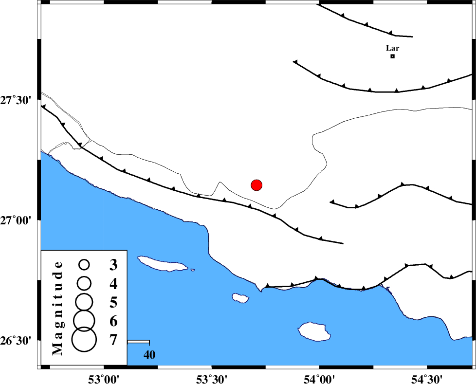
| Location | Lat:27.145 Lon: 53.708 |
| Region | Fars Province, 65 km -West of Bastak |
Nearest Cities |
|
| 4 km of Ahl, Fars Province | |
| 13 km of Ashkenan, Fars Province | |
| 37 km South East of Beyram, Fars Province | |
| 51 km South West of Bagh, Fars Province | |
| 52 km South East of Fedagh, Fars Province | |
| Depth | 12 km |
| Agency | |
Faults within 150 km: |
|
| MFF3 (Length: 292 km) , Distance to epicenter: 11 km | |
| MFF1 (Length: 180 km) , Distance to epicenter: 35 km | |
| ZFF1 (Length: 165 km) , Distance to epicenter: 47 km | |
| Number of Phases | 6 |
| RMS | 0.2 |
| Number of Stations | 6 |
| Error in Latitude | >3.7 km |
| Error in Longitude | 3.7 km |
| Error in Depth | 11.4 km |
Download waveform in seisan format
to download seisan software Click here
to access information about IIEES stations Click here
Amplitude | ||||||||
| UID | Agency | Station | Component | Amplitude | Period | Arrival Time | Proccessing Time | Signal Clip |
| 201390 | IIEES SC | GENO | Z | 0.3 | 1 | 2026-02-06 17:55:30 | 2026-02-07 08:20:00 | n |
| 201391 | IIEES SC | UOSS | Z | 0.08 | 1 | 2026-02-06 17:55:42 | 2026-02-07 08:20:00 | n |
| 201392 | IIEES SC | IRSR | Z | 0.004 | 1 | 2026-02-06 17:56:28 | 2026-02-07 08:20:00 | n |
| 201393 | IIEES SC | SRVN | Z | 0.008 | 1 | 2026-02-06 17:56:46 | 2026-02-07 08:20:00 | n |
Phase | ||||||||||||
| Agency | Station | Component | Phase Type | Phase Quality | First Motion | Observed Arrival Time | Time Residual | Loc. Flag | Input Weight | Distance | Azimuth | |
| IIEES SC | GHIR | Z | EPg | E | 2026-02-06 17:55:15 | 0 | y | 0 | 145 | 331 | ||
| IIEES SC | GENO | Z | EPn | E | 2026-02-06 17:55:30 | 0.1 | y | 0 | 246 | 83 | ||
| IIEES SC | UOSS | Z | EPn | E | 2026-02-06 17:55:42 | -0.1 | y | 0 | 349 | 134 | ||
| IIEES SC | IRSR | Z | EPn | E | 2026-02-06 17:56:28 | 1 | y | 0 | 710 | 92 | ||
| IIEES SC | SFB | Z | EPn | E | 2026-02-06 17:56:40 | -0.1 | y | 0 | 811 | 350 | ||
| IIEES SC | SRVN | Z | EPn | E | 2026-02-06 17:56:46 | -0.3 | y | 0 | 861 | 88 | ||