
Magnitude |
:3 |
| Date & Time (UTC) | 2026-01-24 09:59:20.1 |
| Date & Time (Local) | 1404/11/4 13:29:20.1 |
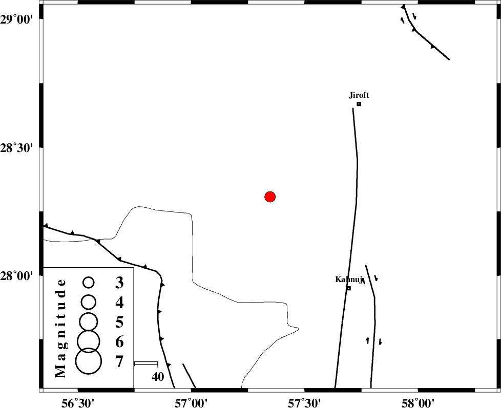
| Location | Lat:28.307 Lon: 57.347 |
| Region | Kerman Province, 52 km North-West of Kahnuj |
Nearest Cities |
|
| 13 km North of Hurpasefid, Kerman Province | |
| 22 km North West of Bolock, Kerman Province | |
| 25 km North of Mehrueye-e paeen, Kerman Province | |
| 28 km North of Faryab, Kerman Province | |
| 46 km South West of Khatunabad-e zangian, Kerman Province | |
| Depth | 12 km |
| Agency | |
Faults within 150 km: |
|
| SABZEVARAN_F (Length: 190 km) , Distance to epicenter: 37 km | |
| JIROFT_F (Length: 144 km) , Distance to epicenter: 51 km | |
| MAIN_ZAGROS_R_F (Length: 1106 km) , Distance to epicenter: 58 km | |
| Number of Phases | 7 |
| RMS | 0.5 |
| Number of Stations | 7 |
| Error in Latitude | >3 km |
| Error in Longitude | 3 km |
| Error in Depth | 17.3 km |
Download waveform in seisan format
to download seisan software Click here
to access information about IIEES stations Click here
Amplitude | ||||||||
| UID | Agency | Station | Component | Amplitude | Period | Arrival Time | Proccessing Time | Signal Clip |
| 201263 | IIEES SC | GENO | Z | 0.6 | 1 | 2026-01-24 09:59:45 | 2026-01-28 08:13:00 | n |
| 201264 | IIEES SC | GENO | Z | 0.6 | 1 | 2026-01-24 10:00:04 | 2026-01-28 08:13:00 | n |
| 201265 | IIEES SC | SRVN | Z | 0.01 | 1 | 2026-01-24 10:00:30 | 2026-01-28 08:13:00 | n |
Phase | ||||||||||||
| Agency | Station | Component | Phase Type | Phase Quality | First Motion | Observed Arrival Time | Time Residual | Loc. Flag | Input Weight | Distance | Azimuth | |
| IIEES SC | GENO | Z | EPg | E | 2026-01-24 09:59:45 | 0 | y | 0 | 153 | 229 | ||
| IIEES SC | GENO | Z | ESg | E | 2026-01-24 10:00:04 | 0.6 | y | 0 | 153 | 229 | ||
| IIEES SC | KRVR | Z | EPn | E | 2026-01-24 10:00:14 | 0.2 | y | 0 | 374 | 353 | ||
| IIEES SC | IRSR | Z | EPn | E | 2026-01-24 10:00:14 | 0 | y | 0 | 377 | 113 | ||
| IIEES SC | GHIR | Z | EPn | E | 2026-01-24 10:00:20 | -0.7 | y | 0 | 428 | 270 | ||
| IIEES SC | KOO | Z | EPn | E | 2026-01-24 10:00:28 | 0.7 | y | 0 | 483 | 19 | ||
| IIEES SC | SRVN | Z | EPn | E | 2026-01-24 10:00:30 | -0.2 | y | 0 | 508 | 101 | ||