
Magnitude |
:3.7 |
| Date & Time (UTC) | 2026-01-13 06:14:10.1 |
| Date & Time (Local) | 1404/10/23 09:44:10.1 |
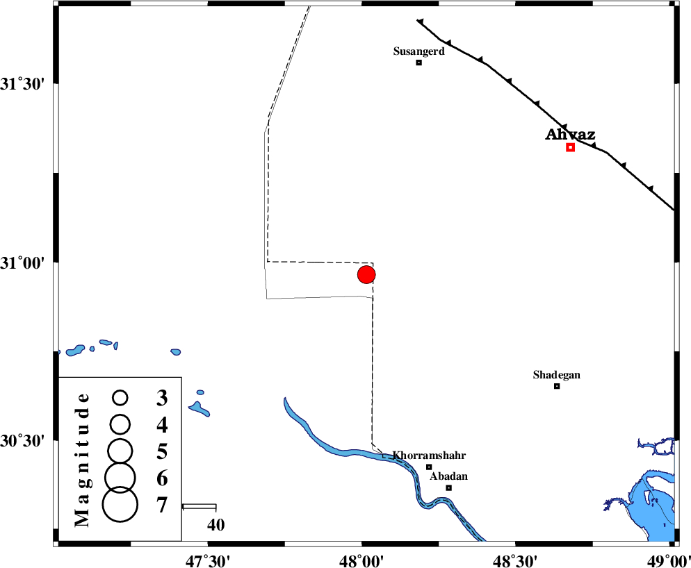
| Location | Lat:30.965 Lon: 48.015 |
| Region | , 53 km North-East of Al Basrah |
Nearest Cities |
|
| 47 km North West of Darkhovin, Khoozestan Province | |
| 53 km North East of Al Basrah, Iraq Province | |
| 55 km South of Hoveizeh, Khoozestan Province | |
| 56 km South West of Bahr, Khoozestan Province | |
| 56 km North West of Polno, Khoozestan Province | |
| Depth | 12 km |
| Agency | |
Faults within 150 km: |
|
| AHVAZ_F (Length: 99 km) , Distance to epicenter: 75 km | |
| AGHAJARI_F (Length: 88 km) , Distance to epicenter: 119 km | |
| Number of Phases | 10 |
| RMS | 0.4 |
| Number of Stations | 10 |
| Error in Latitude | >2.6 km |
| Error in Longitude | 2.6 km |
| Error in Depth | 9.3 km |
Download waveform in seisan format
to download seisan software Click here
to access information about IIEES stations Click here
Amplitude | ||||||||
| UID | Agency | Station | Component | Amplitude | Period | Arrival Time | Proccessing Time | Signal Clip |
| 201083 | IIEES SC | AMS1 | Z | 1 | 1 | 2026-01-13 06:14:39 | 2026-01-14 06:45:00 | n |
| 201084 | IIEES SC | DOB | Z | 0.3 | 1 | 2026-01-13 06:14:56 | 2026-01-14 06:45:00 | n |
| 201085 | IIEES SC | HNVD | Z | 0.2 | 1 | 2026-01-13 06:15:04 | 2026-01-14 06:45:00 | n |
| 201086 | IIEES SC | AHRM | Z | 0.2 | 1 | 2026-01-13 06:15:06 | 2026-01-14 06:45:00 | n |
| 201087 | IIEES SC | SRSL | Z | 0.07 | 1 | 2026-01-13 06:15:36 | 2026-01-14 06:45:00 | n |
Phase | ||||||||||||
| Agency | Station | Component | Phase Type | Phase Quality | First Motion | Observed Arrival Time | Time Residual | Loc. Flag | Input Weight | Distance | Azimuth | |
| IIEES SC | AMS1 | Z | EPg | E | 2026-01-13 06:14:39 | 0.7 | y | 0 | 176 | 47 | ||
| IIEES SC | DOB | Z | EPn | E | 2026-01-13 06:14:56 | -0.4 | y | 0 | 313 | 3 | ||
| IIEES SC | HNVD | Z | EPn | E | 2026-01-13 06:15:04 | 0.3 | y | 0 | 372 | 4 | ||
| IIEES SC | AHRM | Z | EPn | E | 2026-01-13 06:15:06 | 0 | y | 0 | 393 | 126 | ||
| IIEES SC | NASN | Z | EPn | E | 2026-01-13 06:15:19 | -0.7 | y | 0 | 497 | 66 | ||
| IIEES SC | QABG | Z | EPn | E | 2026-01-13 06:18:16 | 170.2 | n | 4 | 546 | 15 | ||
| IIEES SC | GHIR | Z | EPn | E | 2026-01-13 06:15:28 | 0.3 | y | 0 | 566 | 122 | ||
| IIEES SC | SRSL | Z | EPn | E | 2026-01-13 06:15:36 | 0 | y | 0 | 629 | 338 | ||
| IIEES SC | YZKH | Z | EPn | E | 2026-01-13 06:15:37 | -0.1 | y | 0 | 643 | 76 | ||
| IIEES SC | TABS | Z | EPn | E | 2026-01-13 06:16:10 | -0.4 | y | 0 | 908 | 71 | ||