
Magnitude |
:2.7 |
| Date & Time (UTC) | 2025-11-30 07:21:12.7 |
| Date & Time (Local) | 1404/9/9 10:51:12.7 |
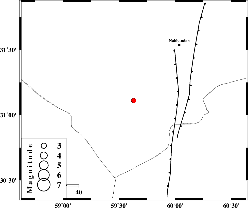
| Location | Lat:31.111 Lon: 59.63 |
| Region | Khorasan(south) Province, 61 km South-West of Nehbandan |
Nearest Cities |
|
| 61 km South West of Nehbandan, Khorasan(south) Province | |
| 100 km South West of Shusef, Khorasan(south) Province | |
| 145 km North West of Nosratabad, Sistan va Baloochestan Province | |
| 152 km South East of Mokhtaran, Khorasan(south) Province | |
| 159 km South East of Kalateh soleyman, Khorasan(south) Province | |
| Depth | 12 km |
| Agency | |
Faults within 150 km: |
|
| W_NEH_F (Length: 158 km) , Distance to epicenter: 38 km | |
| E_NEH_F (Length: 148 km) , Distance to epicenter: 44 km | |
| KANURAK_F (Length: 135 km) , Distance to epicenter: 95 km | |
| Number of Phases | 7 |
| RMS | 0.6 |
| Number of Stations | 7 |
| Error in Latitude | >0.1 km |
| Error in Longitude | 0.1 km |
| Error in Depth | 0.6 km |
Download waveform in seisan format
to download seisan software Click here
to access information about IIEES stations Click here
Amplitude | ||||||||
| UID | Agency | Station | Component | Amplitude | Period | Arrival Time | Proccessing Time | Signal Clip |
| 200393 | IIEES SC | BSRN | Z | 0.9 | 1 | 2025-11-30 07:21:29 | 2025-12-01 04:24:00 | n |
| 200394 | IIEES SC | BSRN | Z | 0.9 | 1 | 2025-11-30 07:21:44 | 2025-12-01 04:24:00 | n |
| 200395 | IIEES SC | SHRT | Z | 0.05 | 1 | 2025-11-30 07:21:56 | 2025-12-01 04:24:00 | n |
| 200396 | IIEES SC | IRSR | Z | 0.007 | 1 | 2025-11-30 07:22:20 | 2025-12-01 04:24:00 | n |
Phase | ||||||||||||
| Agency | Station | Component | Phase Type | Phase Quality | First Motion | Observed Arrival Time | Time Residual | Loc. Flag | Input Weight | Distance | Azimuth | |
| IIEES SC | BSRN | Z | EPg | E | 2025-11-30 07:21:29 | -1.4 | y | 0 | 106 | 333 | ||
| IIEES SC | BSRN | Z | ESg | E | 2025-11-30 07:21:44 | 0.1 | y | 0 | 106 | 333 | ||
| IIEES SC | ZHSF | Z | EPg | E | 2025-11-30 07:21:44 | -0.7 | y | 0 | 199 | 147 | ||
| IIEES SC | SHRT | Z | EPn | E | 2025-11-30 07:21:56 | 0.3 | y | 0 | 288 | 12 | ||
| IIEES SC | TABS | Z | EPn | E | 2025-11-30 07:22:11 | 5.1 | n | 4 | 368 | 320 | ||
| IIEES SC | IRSR | Z | EPn | E | 2025-11-30 07:22:20 | 0.8 | y | 0 | 474 | 165 | ||
| IIEES SC | YZKH | Z | EPn | E | 2025-11-30 07:22:22 | 0.3 | y | 0 | 498 | 287 | ||