
Magnitude |
:3.5 |
| Date & Time (UTC) | 2025-10-26 16:49:19.3 |
| Date & Time (Local) | 1404/8/4 20:19:19.3 |
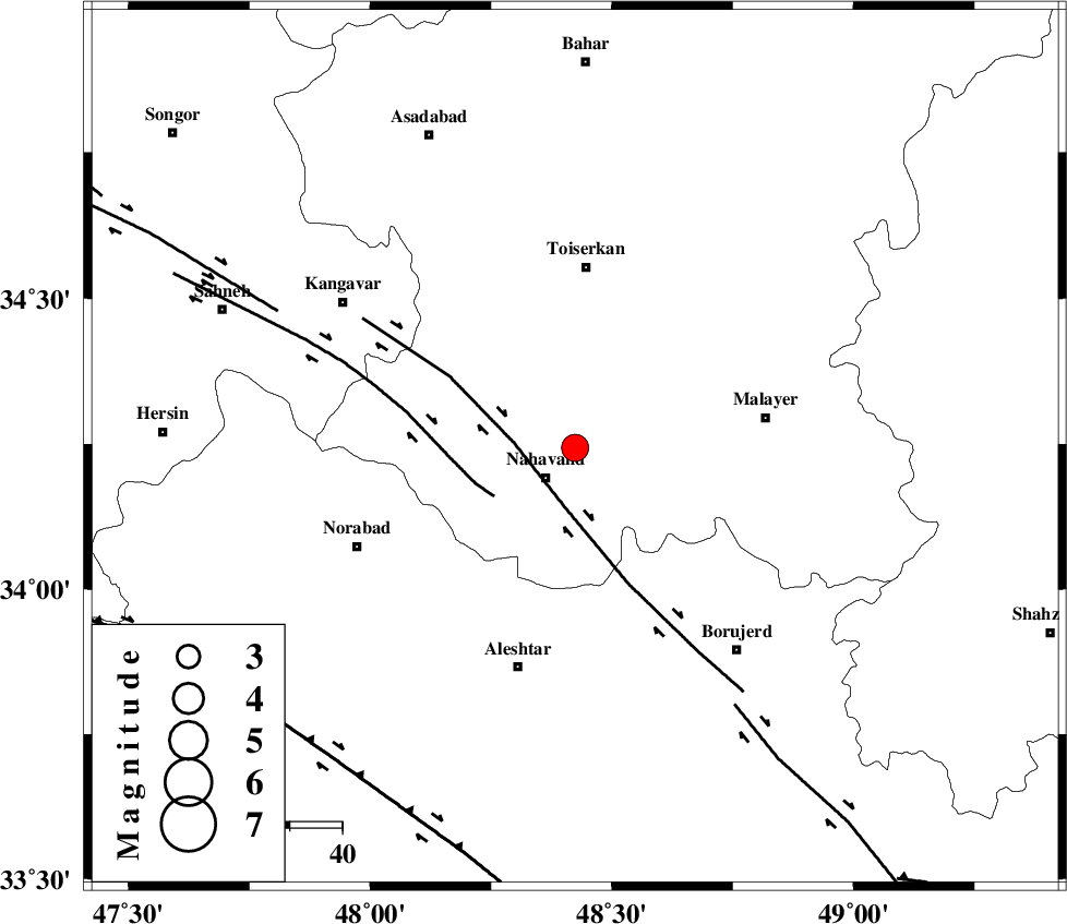
| Location | Lat:34.244 Lon: 48.424 |
| Region | Hamedan Province, 8 km of Nahavand |
Nearest Cities |
|
| 6 km of Avarzman, Hamedan Province | |
| 8 km North of Dehghul, Hamedan Province | |
| 8 km North of Nahavand, Hamedan Province | |
| 15 km North East of Barzul, Hamedan Province | |
| 16 km South of Miyandeh, Hamedan Province | |
| Depth | 12 km |
| Agency | |
Faults within 150 km: |
|
| NAHAVAND_F (Length: 102 km) , Distance to epicenter: 12 km | |
| SAHANEH_F (Length: 77 km) , Distance to epicenter: 18 km | |
| DORUD (Length: 100 km) , Distance to epicenter: 58 km | |
| Number of Phases | 7 |
| RMS | 0.5 |
| Number of Stations | 7 |
| Error in Latitude | >12.2 km |
| Error in Longitude | 12.2 km |
| Error in Depth | 778.1 km |
Download waveform in seisan format
to download seisan software Click here
to access information about IIEES stations Click here
Amplitude | ||||||||
| UID | Agency | Station | Component | Amplitude | Period | Arrival Time | Proccessing Time | Signal Clip |
| 199846 | IIEES SC | GHVR | Z | 1 | 1 | 2025-10-26 16:50:00 | 2025-10-27 05:53:00 | n |
| 199847 | IIEES SC | SRSL | Z | 0.2 | 1 | 2025-10-26 16:50:10 | 2025-10-27 05:53:00 | n |
| 199848 | IIEES SC | ABGH | Z | 0.01 | 1 | 2025-10-26 16:50:46 | 2025-10-27 05:53:00 | n |
| 199849 | IIEES SC | TABS | Z | 0.02 | 1 | 2025-10-26 16:51:06 | 2025-10-27 05:53:00 | n |
Phase | ||||||||||||
| Agency | Station | Component | Phase Type | Phase Quality | First Motion | Observed Arrival Time | Time Residual | Loc. Flag | Input Weight | Distance | Azimuth | |
| IIEES SC | ASAO | Z | EPg | E | 2025-10-26 16:49:42 | -2.1 | n | 4 | 151 | 77 | ||
| IIEES SC | GHVR | Z | EPn | E | 2025-10-26 16:50:00 | 0.6 | y | 0 | 261 | 84 | ||
| IIEES SC | SRSL | Z | EPn | E | 2025-10-26 16:50:10 | 0 | y | 0 | 349 | 309 | ||
| IIEES SC | GLO | Z | EPn | E | 2025-10-26 16:50:36 | 0.9 | y | 0 | 552 | 63 | ||
| IIEES SC | ABGH | Z | EPn | E | 2025-10-26 16:50:46 | -0.9 | y | 0 | 641 | 64 | ||
| IIEES SC | TABS | Z | EPn | E | 2025-10-26 16:51:06 | -0.7 | y | 0 | 806 | 95 | ||
| IIEES SC | BSRN | Z | EPn | E | 2025-10-26 16:51:35 | -0.1 | y | 0 | 1030 | 104 | ||