
Magnitude |
:2.9 |
| Date & Time (UTC) | 2025-10-04 23:00:11.4 |
| Date & Time (Local) | 1404/7/13 02:30:11.4 |
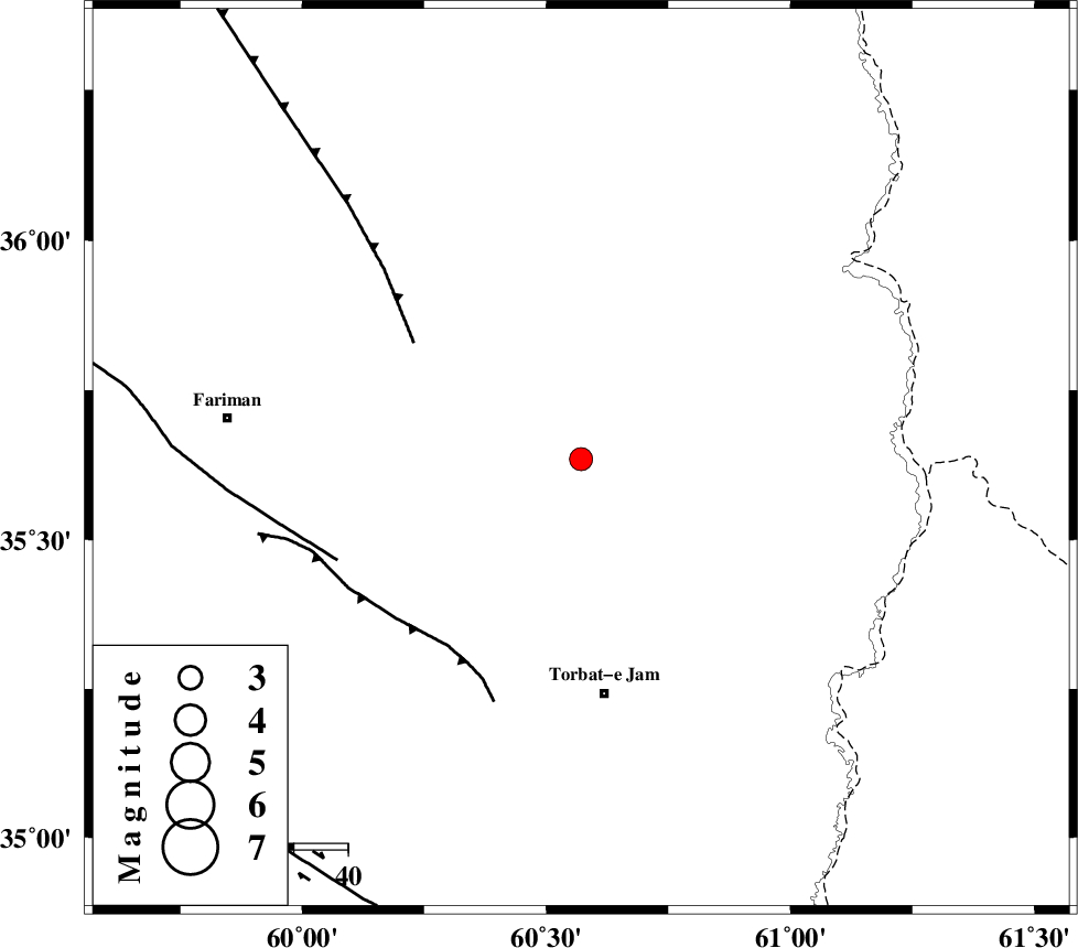
| Location | Lat:35.635 Lon: 60.571 |
| Region | Khorasan(center) Province, 44 km North of Torbat-e jam |
Nearest Cities |
|
| 6 km North of Musaabad, Khorasan(center) Province | |
| 32 km North West of Cheshmehgol, Khorasan(center) Province | |
| 34 km North East of Nasrabad, Khorasan(center) Province | |
| 34 km North of Esmaeilabad, Khorasan(center) Province | |
| 44 km East of Sefidsang, Khorasan(center) Province | |
| Depth | 12 km |
| Agency | |
Faults within 150 km: |
|
| BINALUD_F1 (Length: 178 km) , Distance to epicenter: 38 km | |
| TORBAT_E_JAM_F2 (Length: 57 km) , Distance to epicenter: 43 km | |
| TORBAT_E_JAM_F1 (Length: 71 km) , Distance to epicenter: 49 km | |
| Number of Phases | 7 |
| RMS | 0.3 |
| Number of Stations | 7 |
| Error in Latitude | >5.5 km |
| Error in Longitude | 5.5 km |
| Error in Depth | 9.4 km |
Download waveform in seisan format
to download seisan software Click here
to access information about IIEES stations Click here
Amplitude | ||||||||
| UID | Agency | Station | Component | Amplitude | Period | Arrival Time | Proccessing Time | Signal Clip |
| 199495 | IIEES SC | SHRT | Z | 0.2 | 1 | 2025-10-04 23:00:46 | 2025-10-05 06:33:00 | n |
| 199496 | IIEES SC | SHRT | Z | 0.2 | 1 | 2025-10-04 23:01:12 | 2025-10-05 06:33:00 | n |
| 199497 | IIEES SC | TABS | Z | 0.03 | 1 | 2025-10-04 23:01:08 | 2025-10-05 06:33:00 | n |
Phase | ||||||||||||
| Agency | Station | Component | Phase Type | Phase Quality | First Motion | Observed Arrival Time | Time Residual | Loc. Flag | Input Weight | Distance | Azimuth | |
| IIEES SC | KAGH | Z | EPg | E | 2025-10-04 23:00:37 | 0.2 | y | 0 | 155 | 339 | ||
| IIEES SC | SHRT | Z | EPn | E | 2025-10-04 23:00:46 | -0.1 | y | 0 | 222 | 187 | ||
| IIEES SC | SHRT | Z | ES | E | 2025-10-04 23:01:12 | -0.4 | y | 0 | 222 | 187 | ||
| IIEES SC | BJRD | Z | EPn | E | 2025-10-04 23:01:04 | -0.3 | y | 0 | 364 | 309 | ||
| IIEES SC | TABS | Z | EPn | E | 2025-10-04 23:01:08 | 0.7 | y | 0 | 386 | 235 | ||
| IIEES SC | BSRN | Z | EPn | E | 2025-10-04 23:01:21 | 9.2 | n | 4 | 428 | 198 | ||
| IIEES SC | AAK | Z | EPn | E | 2025-10-04 23:04:49 | 92 | n | 4 | 1433 | 57 | ||