
Magnitude |
:3.6 |
| Date & Time (UTC) | 2025-10-05 01:36:16.3 |
| Date & Time (Local) | 1404/7/13 05:06:16.3 |
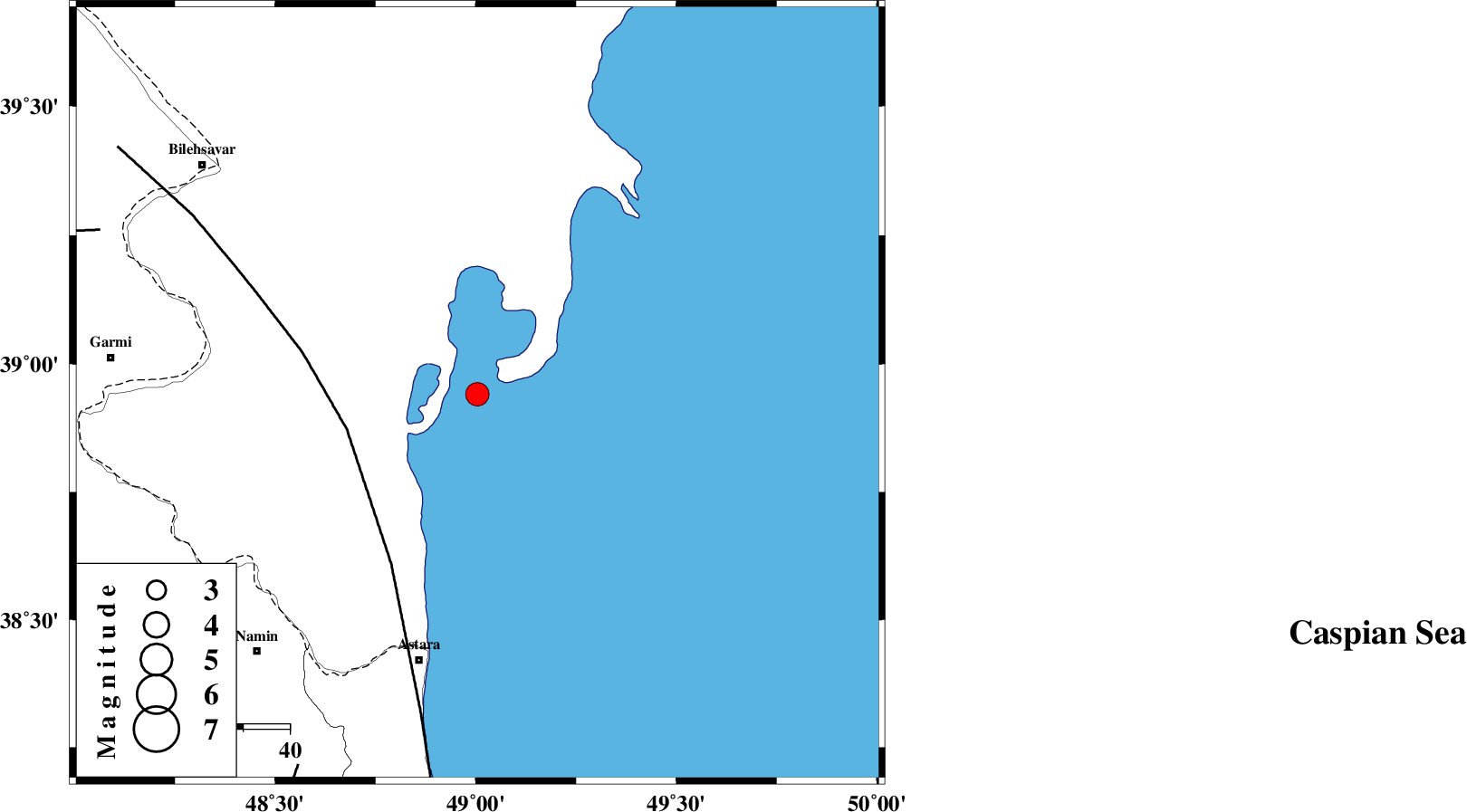
| Location | Lat:38.941 Lon: 49.004 |
| Region | Caspian Sea, 59 km North-East of Astara |
Nearest Cities |
|
| 59 km North East of Astara, Gilan Province | |
| 63 km South East of Hasan khanlu, Ardebil Province | |
| 68 km North East of Anbaran, Ardebil Province | |
| 69 km North East of Kiladeh, Gilan Province | |
| 70 km North East of Lurun, Ardebil Province | |
| Depth | 12 km |
| Agency | |
Faults within 150 km: |
|
| TALESH_F (Length: 258 km) , Distance to epicenter: 29 km | |
| DASHT_E_MOGHAN__ (Length: 104 km) , Distance to epicenter: 89 km | |
| SANGAVAR_F (Length: 61 km) , Distance to epicenter: 89 km | |
| Number of Phases | 11 |
| RMS | 0.7 |
| Number of Stations | 11 |
| Error in Latitude | >3.1 km |
| Error in Longitude | 3.1 km |
| Error in Depth | 7.7 km |
Download waveform in seisan format
to download seisan software Click here
to access information about IIEES stations Click here
Amplitude | ||||||||
| UID | Agency | Station | Component | Amplitude | Period | Arrival Time | Proccessing Time | Signal Clip |
| 199487 | IIEES SC | GRMI | Z | 6 | 1 | 2025-10-05 01:36:32 | 2025-10-05 05:34:00 | n |
| 199488 | IIEES SC | CHTH | Z | 0.2 | 1 | 2025-10-05 01:37:11 | 2025-10-05 05:34:00 | n |
| 199489 | IIEES SC | SRSL | Z | 0.07 | 1 | 2025-10-05 01:37:19 | 2025-10-05 05:34:00 | n |
Phase | ||||||||||||
| Agency | Station | Component | Phase Type | Phase Quality | First Motion | Observed Arrival Time | Time Residual | Loc. Flag | Input Weight | Distance | Azimuth | |
| IIEES SC | GRMI | Z | EPg | E | 2025-10-05 01:36:32 | -0.3 | y | 0 | 98 | 261 | ||
| IIEES SC | CHTH | Z | EPn | E | 2025-10-05 01:37:11 | -0.8 | y | 0 | 386 | 151 | ||
| IIEES SC | GNI | Z | EPn | E | 2025-10-05 01:37:23 | 10.4 | n | 4 | 390 | 290 | ||
| IIEES SC | SRSL | Z | EPn | E | 2025-10-05 01:37:19 | 0.7 | y | 0 | 437 | 226 | ||
| IIEES SC | DAMV | Z | EPn | E | 2025-10-05 01:37:07 | -13.3 | n | 4 | 452 | 144 | ||
| IIEES SC | ASAO | Z | EPn | E | 2025-10-05 01:37:24 | -1.2 | y | 0 | 496 | 169 | ||
| IIEES SC | GLO | Z | EPn | E | 2025-10-05 01:37:27 | 0.3 | y | 0 | 504 | 122 | ||
| IIEES SC | BJRD | Z | EPn | E | 2025-10-05 01:37:58 | 1 | y | 0 | 748 | 101 | ||
| IIEES SC | TABS | Z | EPn | E | 2025-10-05 01:38:19 | -0.9 | y | 0 | 936 | 129 | ||
| IIEES SC | KAGH | Z | EPn | E | 2025-10-05 01:38:27 | 0.5 | y | 0 | 988 | 103 | ||
| IIEES SC | SHRT | Z | EPn | E | 2025-10-05 01:38:50 | 0.2 | y | 0 | 1172 | 120 | ||