
Magnitude |
:3.2 |
| Date & Time (UTC) | 2025-09-28 22:54:43.7 |
| Date & Time (Local) | 1404/7/7 02:24:43.7 |
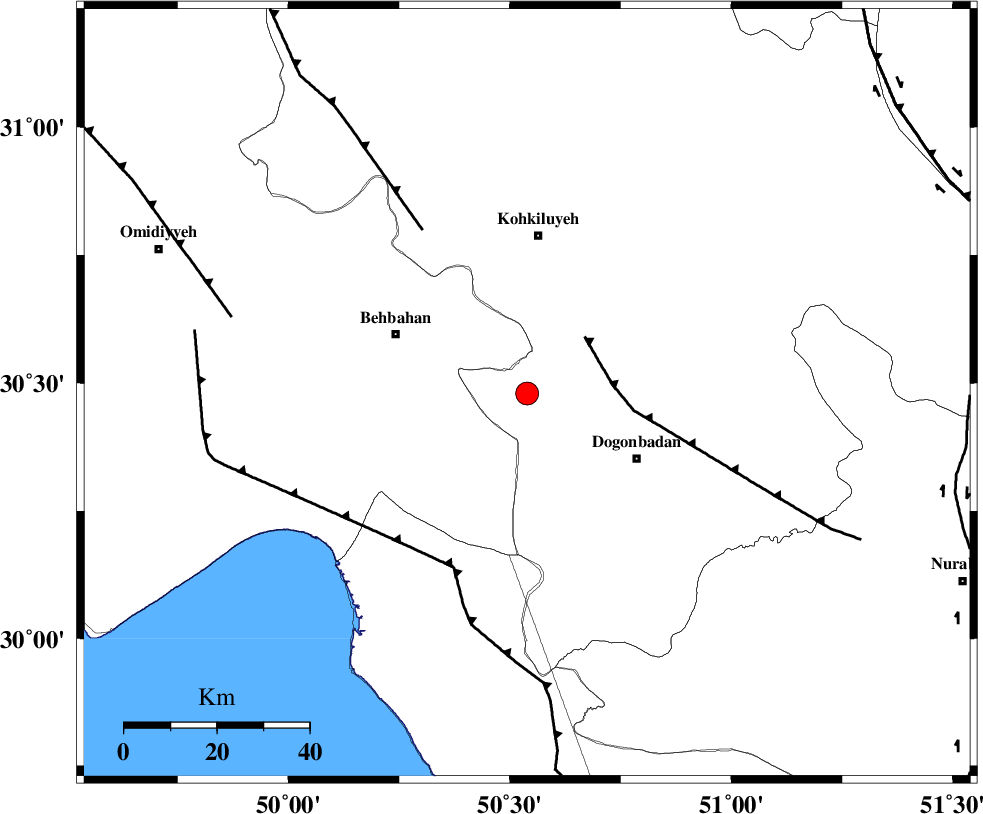
| Location | Lat:30.48 Lon: 50.539 |
| Region | Kohkiluieh va boyerahmad Province, 34 km South of Dehdasht |
Nearest Cities |
|
| 28 km North West of Dogonbadan, Kohkiluieh va boyerahmad Province | |
| 28 km South East of Mansuriyeh, Khoozestan Province | |
| 31 km South East of Behbahan, Khoozestan Province | |
| 34 km South of Dehdasht, Kohkiluieh va boyerahmad Province | |
| 35 km North East of Sardasht, Khoozestan Province | |
| Depth | 12 km |
| Agency | |
Faults within 150 km: |
|
| MISHAN_F (Length: 76 km) , Distance to epicenter: 18 km | |
| ZFF3 (Length: 125 km) , Distance to epicenter: 41 km | |
| RAG_E_SEFID_F (Length: 84 km) , Distance to epicenter: 41 km | |
| Number of Phases | 11 |
| RMS | 0.1 |
| Number of Stations | 11 |
| Error in Latitude | >1.8 km |
| Error in Longitude | 1.8 km |
| Error in Depth | 210.4 km |
Download waveform in seisan format
to download seisan software Click here
to access information about IIEES stations Click here
Amplitude | ||||||||
| UID | Agency | Station | Component | Amplitude | Period | Arrival Time | Proccessing Time | Signal Clip |
| 199344 | IIEES SC | ASAO | Z | 0.04 | 1 | 2025-09-28 22:55:48 | 2025-09-29 07:56:00 | n |
| 199345 | IIEES SC | CHTH | Z | 0.01 | 1 | 2025-09-28 22:56:07 | 2025-09-29 07:56:00 | n |
Phase | ||||||||||||
| Agency | Station | Component | Phase Type | Phase Quality | First Motion | Observed Arrival Time | Time Residual | Loc. Flag | Input Weight | Distance | Azimuth | |
| IIEES SC | GHIR | Z | EPn | E | 2025-09-28 22:55:33 | 0 | y | 0 | 340 | 136 | ||
| IIEES SC | MEH | Z | EPn | E | 2025-09-28 22:55:41 | 0 | y | 0 | 402 | 75 | ||
| IIEES SC | YZKH | Z | EPn | E | 2025-09-28 22:55:28 | -17.9 | n | 4 | 440 | 61 | ||
| IIEES SC | ASAO | Z | EPn | E | 2025-09-28 22:55:48 | -0.1 | y | 0 | 454 | 354 | ||
| IIEES SC | DAMV | Z | EPn | E | 2025-09-28 22:56:00 | -4.2 | n | 4 | 587 | 13 | ||
| IIEES SC | KRBR | Z | EPn | E | 2025-09-28 22:56:01 | -5 | n | 4 | 601 | 95 | ||
| IIEES SC | CHTH | Z | EPn | E | 2025-09-28 22:56:07 | 0.2 | y | 0 | 604 | 5 | ||
| IIEES SC | ANJ | Z | EPn | E | 2025-09-28 22:56:10 | -0.2 | y | 0 | 637 | 30 | ||
| IIEES SC | GLO | Z | EPn | E | 2025-09-28 22:56:22 | -0.2 | y | 0 | 735 | 25 | ||
| IIEES SC | SHRO | Z | EPn | E | 2025-09-28 22:56:25 | -5.1 | n | 4 | 798 | 40 | ||
| IIEES SC | ABGH | Z | EPn | E | 2025-09-28 22:56:31 | 0.4 | y | 0 | 798 | 30 | ||