
Magnitude |
:2.9 |
| Date & Time (UTC) | 2025-06-26 18:39:48.8 |
| Date & Time (Local) | 1404/4/5 22:09:48.8 |
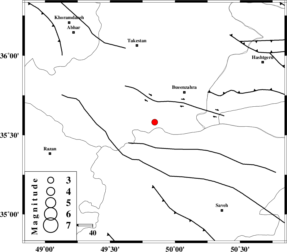
| Location | Lat:35.582 Lon: 49.843 |
| Region | Ghazvin Province, 29 km South-West of Buinzara |
Nearest Cities |
|
| 20 km North of Duzaj, Markazi Province | |
| 22 km South of Sagezabad, Ghazvin Province | |
| 24 km South East of Danesfahan, Ghazvin Province | |
| 29 km South West of Buinzara, Ghazvin Province | |
| 30 km North West of Razegian, Markazi Province | |
| Depth | 12 km |
| Agency | |
Faults within 150 km: |
|
| IPAK_F (Length: 80 km) , Distance to epicenter: 14 km | |
| S_PARANDAK_F (Length: 116 km) , Distance to epicenter: 17 km | |
| KUSHK_E_NOSRAT_F (Length: 230 km) , Distance to epicenter: 29 km | |
| Number of Phases | 8 |
| RMS | 0.4 |
| Number of Stations | 8 |
| Error in Latitude | >5.9 km |
| Error in Longitude | 5.9 km |
| Error in Depth | 17.2 km |
Download waveform in seisan format
to download seisan software Click here
to access information about IIEES stations Click here
Amplitude | ||||||||
| UID | Agency | Station | Component | Amplitude | Period | Arrival Time | Proccessing Time | Signal Clip |
| 198549 | IIEES SC | ASAO | Z | 0.4 | 1 | 2025-06-26 18:40:08 | 2025-06-29 05:11:00 | n |
| 198550 | IIEES SC | GHVR | Z | 0.5 | 1 | 2025-06-26 18:40:17 | 2025-06-29 05:11:00 | n |
| 198551 | IIEES SC | NASN | Z | 0.03 | 1 | 2025-06-26 18:40:47 | 2025-06-29 05:11:00 | n |
| 198552 | IIEES SC | ABGH | Z | 0.01 | 1 | 2025-06-26 18:40:54 | 2025-06-29 05:11:00 | n |
Phase | ||||||||||||
| Agency | Station | Component | Phase Type | Phase Quality | First Motion | Observed Arrival Time | Time Residual | Loc. Flag | Input Weight | Distance | Azimuth | |
| IIEES SC | ASAO | Z | EPg | E | 2025-06-26 18:40:08 | 0.1 | y | 0 | 116 | 172 | ||
| IIEES SC | GIDE | Z | EPg | E | 2025-06-26 18:40:13 | 0.1 | y | 0 | 149 | 359 | ||
| IIEES SC | GHVR | Z | EPg | E | 2025-06-26 18:40:17 | -0.1 | y | 0 | 177 | 134 | ||
| IIEES SC | GRMI | Z | EPn | E | 2025-06-26 18:40:05 | -40.9 | n | 4 | 398 | 334 | ||
| IIEES SC | SRSL | Z | EPn | E | 2025-06-26 18:40:28 | -18.5 | n | 4 | 404 | 280 | ||
| IIEES SC | NASN | Z | EPn | E | 2025-06-26 18:40:47 | -0.8 | y | 0 | 412 | 138 | ||
| IIEES SC | ABGH | Z | EPn | E | 2025-06-26 18:40:54 | -0.1 | y | 0 | 464 | 74 | ||
| IIEES SC | YZKH | Z | EPn | E | 2025-06-26 18:41:07 | 0.9 | y | 0 | 564 | 129 | ||