
Magnitude |
:4.2 |
| Date & Time (UTC) | 2025-06-17 15:25:38.0 |
| Date & Time (Local) | 1404/3/27 18:55:38.0 |
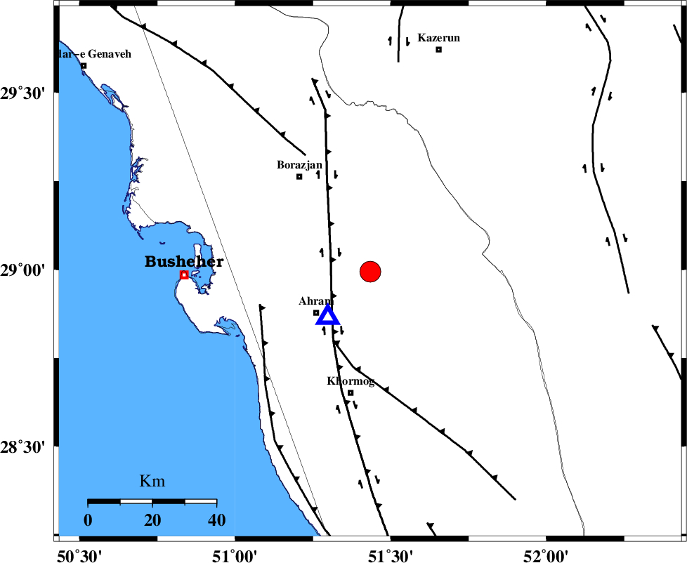
| Location | Lat:28.994 Lon: 51.434 |
| Region | Bushehr Province, 21 km North-East of Ahram |
Nearest Cities |
|
| 6 km North of Kalameh, Bushehr Province | |
| 17 km North East of Bazuei, Bushehr Province | |
| 21 km North East of Ahram, Bushehr Province | |
| 31 km South East of Sarkareh, Bushehr Province | |
| 37 km South East of Borazjan, Bushehr Province | |
| Depth | 12 km |
| Agency | |
Faults within 150 km: |
|
| BORAZJAN_F (Length: 168 km) , Distance to epicenter: 14 km | |
| MFF5 (Length: 74 km) , Distance to epicenter: 24 km | |
| ZFF2 (Length: 84 km) , Distance to epicenter: 36 km | |
| Number of Phases | 9 |
| RMS | 0.6 |
| Number of Stations | 9 |
| Error in Latitude | >4.9 km |
| Error in Longitude | 4.9 km |
| Error in Depth | 13.1 km |
Download waveform in seisan format
to download seisan software Click here
to access information about IIEES stations Click here
Amplitude | ||||||||
| UID | Agency | Station | Component | Amplitude | Period | Arrival Time | Proccessing Time | Signal Clip |
| 198517 | IIEES SC | YZKH | Z | 0.3 | 1 | 2025-06-17 15:26:46 | 2025-06-21 07:35:00 | n |
| 198518 | IIEES SC | GHVR | Z | 0.1 | 1 | 2025-06-17 15:27:01 | 2025-06-21 07:35:00 | n |
| 198519 | IIEES SC | ASAO | Z | 0.2 | 1 | 2025-06-17 15:27:04 | 2025-06-21 07:35:00 | n |
Phase | ||||||||||||
| Agency | Station | Component | Phase Type | Phase Quality | First Motion | Observed Arrival Time | Time Residual | Loc. Flag | Input Weight | Distance | Azimuth | |
| IIEES SC | GHIR | Z | EPg | E | 2025-06-17 15:26:06 | 0.3 | y | 0 | 171 | 117 | ||
| IIEES SC | YZKH | Z | EPn | E | 2025-06-17 15:26:46 | -0.1 | y | 0 | 483 | 39 | ||
| IIEES SC | KRBR | Z | EPn | E | 2025-06-17 15:26:46 | -5.1 | n | 4 | 528 | 78 | ||
| IIEES SC | GHVR | Z | EPn | E | 2025-06-17 15:27:01 | -0.2 | y | 0 | 608 | 358 | ||
| IIEES SC | ASAO | Z | EPn | E | 2025-06-17 15:27:04 | 0.6 | y | 0 | 630 | 348 | ||
| IIEES SC | ABGH | Z | EPn | E | 2025-06-17 15:27:40 | 0.9 | y | 0 | 914 | 20 | ||
| IIEES SC | IRSR | Z | EPn | E | 2025-06-17 15:27:42 | -1.8 | n | 4 | 954 | 104 | ||
| IIEES SC | CHBR | Z | EPn | E | 2025-06-17 15:27:45 | -1.1 | y | 0 | 972 | 113 | ||
| IIEES SC | SRSL | Z | EPn | E | 2025-06-17 15:27:47 | -0.5 | y | 0 | 979 | 325 | ||