
�����JFIF����������C����C���k����� ����������
���Y����
�
X79vx�����8VYw���!#6W�����"y�$%1�&'(2C��)3ADESUq����
�����������
���8������!"1 A#2QTW��BRab��$%3���
��?�����������
wm
r��m��A.9;�Mr�]��[�)6�ҫeu�F�(f��8
��=4���1�$g)�B�0H���BK�9��}���tZT���^�ϥKZ1ۋ���̛�Z١��ӿ
���C#��R
��x�T)��������(����u��j��`�h�v������6��vy�GN��3�u��)�dd/D��(��B c�
qp�4��^
{������د��/�0���m=h�+���L��OZ-������{���b�{,���
�����د��/�0���m=h�+���L��OZ-������{���b�{,���
�����د��/�0���m=h�+���L��OZ-������{���b�{,���
�����د��/�0
|�%o�[9c��
��,��dBH��=�+b6Kr�w� ��LEc0r�� �6�3S�XNX�W9��av_r��~��ۣ�ܿ�����������/�'�7���>��=�� �M�/n���r��~��ۣ�ܿ�����������/�'�7���>��=�� �M�/n���r��~��ۣ�ܿ�����������/�'�7���>��=�� �M�/n���r��~��ۣ��/��y�R����5>ض�j��uZG"a;+lJ�������W��NY��ŪH�=��5���R]84�\�D�+���OZ-������{���b�{,���
�����د��/�0���m=h�+���L��OZ-������{���b�{,���
�����د��/�0���m=h�+���L��OZ-������{���b�{,���
�����د��/�0���m=h�+���L��OZ-���������֫���M9���GnJ�2��W�>��M�ץ�g���qnOn6��Q7�^�O�dQ��Y�fa� r��~��ۣ�ܿ�����������/�'�7���>��=�� �M�/n���r��~��ۣ�ܿ�����������/�'�7���>��=�� �M�/n���r��~��ۣ�ܿ�����������/�'�7���>��=�� �M�/n���
إ�*��,�!:�d�+��nDp�Ǻ�
:)
q~)���[�y�5�4�-^
�����
�p��ǃ����[��e����_����|�Yi�=��i�E�_=�_�`u��z�lW�e�������[��e����_����|�Yi�=��i�E�_=�_�`u��z�lW�e�������[��e����_����|�Yi�=��i�E�_=�_�`u��z�lW�e�������[��e��%��g�6Y����l���
�l� � q�,ԭ�c6�Y��"�%����*�T~
̒3��N+�x����/�'�7���>��=�� �M�/n���r��~��ۣ�ܿ�����������/�'�7���>��=�� �M�/n���r��~��ۣ�ܿ�����������/�'�7���>��=�� �M�/n���r��~��ۣ�ܿ�����������/�'�7���>��W� j�[�9V�M�
v��i+*߉,#kng��t�-�=w_�R�&FB�K��"��Y� �=�3K�����OZ-������{���b�{,���
�����د��/�0���m=h�+���L��OZ-������{���b�{,���
�����د��/�0���m=h�+���L��OZ-������{���b�{,���
�����د��/�0���m=h�+���L��OZ-�������ׂ�03e�c��sw�SX[�� ����m�
oI'�(�ۼ��V���R�|�%a�
4�#�a�x�=�� �M�/n���r��~��ۣ�ܿ�����������/�'�7���>��=�� �M�/n���r��~��ۣ�ܿ�����������/�'�7���>��=�� �M�/n���r��~��ۣ�ܿ�����������/�'�7���>��F
o�t�L�� ��w7�M��Ea�8���^
��u�X䅵���)^U��gg���R� -�����l
���#�=��Q�Xd�������MR$���EHY��Rd�A���Bb�����qX�fG�\�^���������
�8�q��|�9�0�
q�����
�h�rnj���\�9q�>�\�<�>/
�kG�Ԭ�C|�u�̯�#B
Eps@�:�0˛�8�rU)qpH���d�xL�Bn�V�A���L���=�K�1A"�M`~A��*��T�$�IX��j1L�&y8�^��q�a��c�\q�\r
_�u���+� F:O�@�����WN>�t����ߨ��}�?�� ����Q]8�1�b�?__~��q�c����~.���Et���I����]}}����ю�������ӏ�
'� �u���+� F:O�@�����WN>�t����ߨ��}�?�� ����Q]8�1�b�?__~��q�c������SH�)�5��
�f%�6=z��rU�<��8��A?'�W&�|�\ə�
s�^�v r����̥k�d܅������)Z����!jo�����V�f@=�Z�꿮��2��ِr����̥k�d܅������)Z����!jo�����V�f@=�Z�꿮��2��ِ�5Z��1���21O�ջM6B^m*~��C
l��ֺ�&�+��ڀ�ɱ ��!.h�[�l
[�Ux�z�4�;�um��x
/�e�x�#�f���r��M�=��+��e)k��-�ݭ�[�˱�
�,\�Y��/�E�Kw�,�hڕ�4��j7�YZ����ҵ�n��ۿn����Z�꿮��2��ّg=�
S}W���R��2�B��U�w���~̀{��7�]�e+_� :�贉o��[���>@��~�t��5#3L%7�-�
�'3�̢|��/3��
x����8����ߨ��}�?�� ����Q]8�1�b�?__~��q�c����~.���Et���I����]}}����ю�������ӏ�
'� �u���+� F:O�@�����WN>�t����ߨ��}�?�� ����Q]8�1�b�?__~��q�c����~.���Et���I����]}}����ю�����~��"N�ѩ���ړ
�J��D��Q&�<�7�t����ߨ��}�?�� ����Q]8�1�b�j�u����R�b��PhUw�
мk]��H�U�U��
�
���ט
��M��qj�bldy"U�5V�&>R_�hH���J��z��9�Ku���ז$br�Nk�F*�ZC���$~
�|�+טuc'!lŕ�/�'�
�Oq�NY'2���h��&�i�UIN)Be)���!Bug���A�B�0��3
L(���2��
�ˌ��
�܅������)Z����!jo�����V�f@=�Z�꿮��2��ِr����̥k�d܅������)Z����!jo�����V�f@=�Z�꿮��2��ِr����̥k�d܅������)Z����!jo�����V�f@=�Z�꿮��2��ِr����̥k�d܅������)Z���=i
��b�E������U�'�
�tI���3�b�tL�q<�
7
�
�
�
��<��:������WN>�t����ߨ��}�?�� ����Q]8�1�b�?__~��q�c����~.���Et���I����]}}����ю�������ӏ�
'� �u���+� F:O�@�����WN>�t����ߨ��}�?�� ����Q]8�1�b�?__~��q�c����~.���Et���I���2h~�F��9�z� Ty>nz�Mw�Z�
���� i�!�a>S
�Y��
>�������}�Z�꿮��2��ِr����̥k�d܅������)Z����!jo�����V�f@=�Z�꿮��2��ِr����̥k�d܅������)Z����!jo�����V�f@=�Z�꿮��2��ِr����̥k�d܅������)Z����!jo�����V�f@x��w����}�H�I��/
g�T$h��Z��25%�/3���M�&@�?g�|����<����r�C��ӧʷ��Ȃy�DS�y�9�yaA�<��8�<��?��<���������������
w��\_
�{�%x_&�|�
~�*0
�`���������������������!���=y�Z�ml���j[�
9��p��˧3�~}
���\g�ϧ%%j�p?6�R�_
#4�j}��ÿC�7���pޓqzJ�O#�ƻ]�mN�? �T����.��c���;�J�s3燯���˵ޛ��Y�k�3����>Hw�+v��[V����iJ֝���N����� �[�Y{.�z�����x���6"��ȗW�+�+e�63�fD�
wd��.���<|��5
�շ�����i��kqu��w�"˿��旒q�t�i���8Ru��!��&|�+�����S���[�
�r,�
����+�ʽ/��;җ,ޝ+s�{w��;1�R���j�v��#���rkyA"���Y�yQ��k}��ӻ2������(
�U�Z��?�99噏�e��q���6�M�#Y��lsumne�������7p��r�K浑��f����
���ѐ6�B��]�*N��F�ƽ�8N4�%�t�kJҿ��xS�����������������������C��ի������=��� ����V�����s�lB�d)! *8<�Q4{{sJޱLJC�[粽��;ZHYgO6Ɵ�-k�v��}��"韛q3"�t�;a��x\�9yg�)D*H��1"I�f�[�Z���V�4��
w��ڼ�uz�e���3R��l�&�]����>Q�ꑒ\6�Z&�0qs}9Z�֧�Z�
�G?]�L0���������������������
o��e�mГ��{����ڢ��
���%
�7�O${d�vy��>]%`��5�qF�id���Ǖַ_Q dׅjt����o-�z<���X�ky6�
�M|���������嗭��3�z]��
�ZZ��� B��y�����Ͼ&�U��-~[���^���,R��J~W=j�ұ�8�gE�u����������
�f�1/'aTC��r�
��s�
�9�f
�F�rI��>И��i\y�C~Ў�O}N����}�9�Ǯ'Jy4oy%�w|N9T�X���)�L�z�
/�/i8��6���7
�<[>'����me���͝g�����K�������5}�]�iO�����N�0�*7ν-�y�T���[�ܹ[+���(:cg�k
����-kHZ��g��D��C4r�5���xV�����7Y(�}�cKԋ8v)�i���&�v6cH�����˽+q�NC�����s;�cڭ��7��-6D��]��ì��s���S��V'^��ҝ)JR6kU���@����������������������{eh�3;Gd
�
� ����:�%sc�C�SP�68�S��� ^��,J�� P�� 7
��,y
RAL|�ɢ���d���a3���g)!��G��s��rC���r�#c�^e�Y�`D�H�l��t
�B)���IX���'3�:8$ZQ������������������Dh�B��rF����
�����b�й�2?_����ǖ�X�s*c*J��ЃN��DL`��dBs����*"�5������5�hyǤ�.2��gIO�����/P��#�Td#l�-B,�v�d e#�BM������������������#�>�j3�T;`�"��X/�\>��T�L�)6g)LC�r��7J,��K�X���x��ܗ�T�*U�8�騷V���K.�A�}w�j��4�G�4��_��KC�;����|���ثs*5K
V+F�ko�ȗ��d^����8
�
�X�l�%c���
:E�YD�%#m��H�s
��Z��D�
I��=����N',�4�0�;��������������������������V2����~#�����������������
w��\_
�{�%x_&�|�
~�*0
�`��������������������4�� c�:��I|�.�&�[د����.19ZI[�/a���78���V�H�=Y��*�"��^D��y�����
{��6�WotۅW �u+&��,���_����ݥc_��+V�s�f弸i���ʓ�V���V�]U۶�Jfd��çִ�*|��~��g�}ON����J�j����٩�
?Jk���n_�O�GY
vY������n\_4�d(��\fS�
X�Mbv�1���<���������W
�G
�>y��l���'�����ķc�o)�.<���k[�kKǫI�\����a�K���ڤS�5�6X��^�
\)G"�r���j�Ϳ�W�gJܻ��c,�V�*�z���*�ki�Ee���)�l���
i
]o@xL��6)iwE��H�=9��To+LaJ�(�i%I%�/�G�u�r�;�8��V���]λ����G��m5YV�p�)��n�a~�=K7c;7���ބ�Np�Ց��ʱ{�V
�7����W"�iBq�eO�����i�J�Ҵ�
[V+m���e�:S#
��]��
�Í�Z�cv�V��kN��<�ӓM�nKavC2x�k��Ky�b@��ҎS��s.�s;���ۋ�����Q��bV0���p|��4���e�M�
e��1����av7!�_�ce����^��-�t�j�Nܿ�nt�%�w�{{v�D������������������������PC�����
������mIT⡺vfʩ�K��-�u/wB%GE[k��Xۙ�
��Q�W6�TI�!S�yH٣��[�sm��j#�}j��a�$��&�35�Ԣ��E_�Q%V\ZDž8e��[T�&�Y�� �\�qFs�}�;�u��pW_�=۳4���%�|�[]�A�8�ҫ
�Č7�
��/lQ������^M̨�HkN�Q��#\+.Lo�V%�8�@����������������j�Aѩ�*��o���[
y��������ti��榩lG�Ɲ�0�Zڝk�)>��5�0��85;�M����8 ���Ü�iz��Q��d�1NoW�]\
,�F�O��W�k�!��T�dZgS�z3l@�цxpz�a ���������������jF��؛�f6�V�i�]Vm`�T�x6���a9PH�Nj���v��{!i��t��:d�,MVW��H�D
__c�� ��a�Jf�$��S��f�kR�R݂��m��N�y��������j���X��F�V3���[�����Ne������1��ņ_>z_'I�Y�]��C���~RM"(�Jb�Xa�9��Zm��E���V
��K�k���*MY�늗xQ��
�T��je�][�R�X��*k�~��4'[�����T�7Y��
=�7k@���Ԫ�ϐ��+�4���E
vl��� zb}e^�ՙ��)K�
�\Кz'�G���g��bS�P�� 3
�L�����������u{��]
��ϱ��yL'����s�=���!p��o3��x=��*��{����QfX+lm�-
���:epp)s���Hw���n�p� .2��뀬��;r�̍�!�
��a�M��d�����eE�
\�f)E5eg@�@Ɲ
�l8��������� ��v
�uS���X��W���P��p��������C_;���/�[=��� ��j>G?]�L0��������������������f>�;/��
���d�U�.k�|��^5���?˼L�*+$��4�Τj�ZW���F\M3��~0�����>z��^{���nQ�?R�X|�d۹�ȷ�������/k�Ʒ��٭��F��m�,#���4U�4
�y���x��b>�
%��J��+�Wk ?��O����=8J�%������x ϽA��f��`�O���_��k��L�?rO�,��W���!�1����p�?�z��h~����>E������NI�%������?&7� �
��P}�������ȿ������ �?���^?��Cx<�o���^�Z���Sv�L�2��ې)����#��׆���92��F��x��q��f[d�4�G���e��S�.뇄����I��/�d�SGX�C���|�Gc�q����ͻ��j����
��
��51��Ur~¨�E��+��7�Q$��Z��."8�������}dt�<�)���-M�C������ٚs=c3�va�zK�}gz�%Kd�I�w'[dջ]L�-Cr�9�U�9ld\I
�#s76I
~X��b脩�MZr�Z۞
t����������������5_�72�{��M���>��X}5eMO��o�V�rwxlE*�\��Q�W���\��6ʪo c1�kl^p�r0��Uy@�
{�
f�"������ �l�yc\��(ƂW̬�NK�
p���#���_�C��HpH�bG�����������������6�aa��wN�����S5ܖt�Z�
lc¦��sc����g��`���\V8ܕ:�ί�-���Z�:sDm���;VB �¢�[��rl�c
���룻�{-��v��$)�q9�N�7��e�B\,Hč���T���8�5[ª�B?2�A#��Ɯs% JՖ��pR��j&�J����@�R�:��ps8�Vo<�@Ž��ə�#�6��}�[K��zGVw���f�sk�b�D�1�'V�Y'RA��qy��X�X��&�u�s��u��}Ϡs�I�&�ZӶ�C5a�j99R�J�$<��!�M��5
��9{�67��
�@�pu����Ls�j�1>��
TFH�Y���0��F��� �6L����
�!�/+ex�<&J�ر1A�����������h�������IW��a+JWtT6�YЇfT,��hˬC�q�'�)[��P�9�%��e��L��
� ɠ'��h�_����,����،m�6
jMK5��b#�r|A�c�rD�k4ÔAl��yYY��85��Sskxba���#�����Fd��6�)���.%�dۦ�b������"jox�$Z��Ƣ�����
�`�h4��Ȑ�@�����x�x@�
�`߷U?ʱ� ����{�
'��g���������5��������(����A6��p���Q�����������������������������������������������������O��5Z�� g���^Ty�j��{��xL_�m��s�;{��BrQ���6>�E�βזH��Q���J*ԂK� �cѹ���CKQ����m�#�ZD��G��V*!BRBAD6�Y�Kt�TT�l�
0腹���]3bC�7������rfm���
qL��[������I ������zخ.�T\�o5���訬�L�~Ь�XL�֗��b��^��%(ҳp��B��
�:�D�RƩQ�R���J����Yte�[�ú�m6O9�X��Em
NmvJ�+��<1-P��C{� ��j%�
�N%
Ve� ������� �z>��i�1Y8\15�M��6z�0�J�3"�c��7a���[�.��L�m38��]
� Q���2pwl
��l�
Z�A�ll@�|Ƥ�g����B�L�e
a|�LdJ��r�;ʥ.���F)tv^y��*<����������:ŷ�������Y�˟.?s}�K���]��o
]1��i�ɨ[~nن�^٤�^�+ȋo;
��1���TS�m
I[�ԕrK�뛲���[^F�����>e)�ݔ�
�]�� �d��z��ܖ<�d��'��^P������t=��Ϲrx���#k+4+W����J~�����-kV6���pٻ�_$�*w��˕Cb�q'���S���$�B[Y���TZ�͔��br�ڗ8@X�m��.qfC[!�
����O |)c"�Idj�T�A����JsO�2�}oT��]j�B��Z�,��r����� 7�(�VG
ܓ�Y��Ne�ɞ.x
VX��&a�!�U��n�4�]u�
uz����po��ZH�u�3^B^�g8c����ßvj����l<���X�q��ev �4�(��7���D��Y�b�92H��adYG���븻�L�~\�;�[k�h��%���8�Fke�[#6��@������ Zh-��^i���aW%j��9��M��r%�H=:W��<���5���%�wy;
�����p?��Ho~�*��#���
�s��co��%
�@�
p��.�p��^�o`o%K�e�l)f�g�}�`�\1�Je���
���,�/\ڝ`n%@�@���}���M��F,�v^O9K����'^�+"���z
�d����0�4��v+�q��K�'Xu�UI��"gR��؝����R4�<��PUe(��ƥ�����v�M3�(�+�p�Jû�Wn�.��>�
�~lr'Wx
�.y�5��͙�i���- -��̨�8H�:u�[
y߃����1N��x`������l5���K�S$o�B[�QK.��^������h������噭l�(��ukG?]�L0��������������������������������������������������
,�9 �G��2�F�,ZR��
�� P%uc�G�О����ָ��95:�*R���NJ��'PQ��
�(���0�����uF���
w5�!=+ą�V/$�y>���c��0�����rf\�I�GĔ�/��'���/B��bĎ-�)�op@���W�XN
,F�>f'T�Rs
=:�
̓��J�,2�.C�������������������;D���Av�l����땻d�̐3�u�aXC��k�%�$��!E1�0/u�8`�7*@��챥�4��д;� ^��jWh~��UFD��n�Z
���pk8��1�j��e�ےEg�����������_! ���L�,���� J� $���QH�&-De��g��T� )*t���D�(�
���
�=kku���b��e0%��q�E٫�������
��՛5�
��ȝ�_=A�\�A�́������#� ���t:i.�ȝ/�����Rw
J�Q6
���7!��S���9:��Uk�mR$�űf�
�X�3��Md�)n �����$�l��v�����Y9������n��S%S7�ߋ�Y��<.8�INtp99*��g�Vv�U��,�QfI��=_�'��WN����ͅ�N�ɗ���ƭ�F���˛��,O
�(��5�T+�q�=|���M��bDG�|�5��J�6��0ְX]s$��J9
�'Rw*T�gF��I�9�O8�� �4�pǓs�,�� ��;h����cV��=��9��R��C��*ŶW�6�ym2؋�$��c�yj���ʐ���{�bJ��}}cryzSNs
�ʩښ�%�z��2�B�`1��X��+po�<ר��l�63x��Q����N-�$.���+T�8
u�+�~��a+b�d���
_
�6���yC%%"�j��7����`jJ���0[6-ܣrC�KaɊl�.\��ߎ�ck����U'i
Q���[�_�ڵ�S˱M<˕2�e�5�D
'���us�#Qk��J�Q���3�v��8I\l
��ZK��PJ�7�D��29.soHq�Q7X�yRλ˳����4�%Z�tN-�`�7�R�&eY�u��!��E�-������h^�jg��
Xʒ9��حս�й�: �e-����JB'B7J�ܽ��4�b��,�l���t|������Ws���q��ٲu�[�K���ME
��FI~�+N^A�d�;�Ȧ��d�1X���F��,�F��Ȉ�G<���yh��y�Y��
�Yy��8�M�������=֘
�����]
�͏��<¡?86�˛��-�ĥ����s,�L��ɬ�$Z��sn����c�t�+���
~��[Q~/U�����
��kZ�)T�A_���ҝ�d�/��3�]��
6��
^�ԡ
���a�xbYx�xc�a�ǒU� �6Wu䜳��8��8,oRQa#��q�
�2�F����'���L��9��4��5�[�rҏF�����-D���*Lq�
Q��
�`�!b����kL��:Q<�v�
[���
R�'̟j ��ѵ�PЌ�{c����-��U<3sGZLò{��w;�@(�s(�*�/�q��(��Nx�w�Hs3�r'�"�c���w��
��vI��՛.\���M�
ȥ�\q�U�P�I�������)J~<�m�Sp��W��2�IC)A�Z��!J��Ȁ�I���
�A��a s���T����YqɅ��&��ƽ*5�g@�����$��Kc��jQ,T�F
�6��c�
̰�NW?ju���@�?���U�r(�����D ⱹS�x�
�řz�T'RBE��D� \�F�>d�m ��[��5��F����'�Z�%h[r�IsDŽ�SO
��P6$N��r:EWZ'����)oZCO���n�٧"�lu�tl���[� 5�3����Lɒ�f�>�m�@kHZȓ
s��XhFw�d�2�̺
ޮP��u�h�c
q�W�g+1y����,Q���c��1��y�7������^������
\�q�
Q��ޒ;�
~�j�/"I&���n�C����d�6Ζ+���(��ż���sf
LmJ�a��d�
�!�TL��
Y�ъ�8\a�Z�����)$�T��Ҩ�
���●<�'x�\����S07 ���#U�Zy�Z+�F��Mwa,����xf����ݒ��28�A,�멎�Z�<!:�Y�ܼ���crВ�0��E�l��0/QX�m��'��p��On��ԐI&!q�ٽ{D� ����y��мF\�ŹyH��YcϬ���Mn;�:�N����V�͛c%c���W(R������ �yܶ�^�#�iD}�ؚ�-��[)���������U�a����bl �J�
���kin$��T Ѥ,��1R�
�?�r=j�*V�0�J;0�������1D����$9N 1�w�D�C\���2OpTN)�e���4�
i`NjX �Tr^a�|\1��E�zPŘI�]�B�m' 3P����0v��(�$� �!�a!'�`[�.0���JP�|O�OsR
D
�Ț彽o���%�5�]g+Gë3�u̲�F�ȗ
��e��d�lxmB�Af'X���̼C��}��߈�?�(�{8������������
�}��-�� F����� � #� �ʌ�����������������������������������������������������
����N�u�
�L����I��P�㯫"r
�Y���Z,Brl�$��k(�{Ѫ)�O�g�"vmjQ)L�
�F=�0�_�EGl�"[˯D���� 1�2V��x��cjDi�����B��Nrz��N�:f�!�P������������������YW�X\�9��*��Ɖ����|����U.��%��F���j��D6���i9&,d�
�$�o�( ���Y5��tцة��1��:� zo�4���'���6H��9�<�~�>�5�%N���4� �1�
����
Q�M�PI�syЈ�8���[n�O
qK���*f絮-#���\���b~%�a
��ɕ�m
�aI`��� �D����J��W�\�`��'�I�g�2%��3���v���4�
M@���ȝR@Ŝ����c�K
~��?�*e����*%xq��4���!"n��7�X�$��py�{>P���2�����������/�Cl%1y�J37��11�#���+��
Z�f�hyH���*(�)�5>yye�W8��9pW�]�3�W��YqT��3��S@���q�8�e�0T�Gi�*��A��v"�~Y��_ IA�#&8?�5}��gE�}��?�r�5�Q���s�J7
���ӏ ������J�
8�j�dkY��7��t�ά'VD��B���_�9�Q��I�4�0�<�6��P�,z{�
sw8
�'�B
��/��U��������������!�|3
�~�T��*�@~V>����x���=����������P�Î������@@ok�ڏ�Ï�eF�
�����������������������������������������������������G��ԛ�A�ҿ�ϯx>/���̝��Q�ӵ���pO���s!"s�Rv1�D�O^Jj}]
P�_�e�g�H�hX�J���=d�6��x1ν���:��w)��D_ҙ�|� -H��D �C_�/`{NB�(�T���K
�7�* L����������������(m�-.�aM��O��.�R
�k�D�vhs-[Jɭ;)R��
W�_�1�\�)�E�
�rq�Z)�N�"��t=��Z�-�L�ωO��\�
,N܆m]X����`�Sv�GƤR�d��ѕϖw���� �|��H#�ώ!������������������������������������x�x@�
�`߷U?ʱ� ����{�
'��g���������5��������(����A6��p���Q���������������������������������������������������������:�6>�8�=� xfx@��ݡ�w�V��$^��Yg$\�rC�L���N�9�qy��X��l�o�v0�W �˥n�-wuI�qF�yq8�(��1ǜ�r�yl�-Xj�N)�U��mr���]`]�2�����H����T��N�9�bi�yYdQĜVX�Q��a�9�8�� ?�����������������
l�9����DbJ�j� !����*r(�Rr�E]C��:��Ya�dj=YS��|�8�D�Ѹ%�De�
v���������������������������������������!�|3
�~�T��*�@~V>����x���=����������P�Î������@@ok�ڏ�Ï�eF�
������������������������������������������������������S�}2���[�=^ؘ�R*��@_
)Dw�H�2f�S��
8�<��g>
pmQ�g�W�*^P��9:5�
��i��f��
��b\S�T��>�VJ�f
��.���H����,��I��-�lX��%�� ���ֶe�-
w������������������
�; Z��#�c�E-�-� �X���sL��jp1:��Әa
S
Y��I��na�X�"�pY�v\_Q�� Q3tʓi��"q�ۘ�1�t�\��o'p�N.2��W9N��<){��4�ra�:.��Ke�Hl������������������������������������ ��v
�uS���X��W���P��p��������C_;���/�[=��� ��j>G?]�L0�������������������������������������������������������.�w����ks$ֈ0�~�j��kkT��(�$J$Q����&�N5l�%
��F\�8�G��#/�*Jك�
����{'��P��8���=XuGU��B�GB�mx
�m�� 䔧�Geאָ�\c�%%\^��S���#���ݰ����������������
;SL��G/������?���G�54�aB�M��ɎY�a�����QY�
25�S�ygt���X���uJӐޚ���l�3t����NL�
N�$y
���#�פlI
�]ܒ�%rwRCZwg5����ո�?������������������������������������� ��v
�uS���X��W���P��p��������C_;���/�[=��� ��j>G?]�L0���������������������������������������������������������/Lm]�;��֛r�ui7ziօN !��'�mm���
#A<�ax @�����'��Y��4K+�W砲V��-�z�[����I�*UG%�Js !2�Ҧ2I^�Pa�����������3�
�N\����%0�����������������s�}{�W+�n�ٲ٘0�R���7xV�{�
����
OP�"��{rƆ9���72٘��:����@g�꿈T����Y��@kHlb��ljV�yL1k"�i��Ϊ��,-���
�.X�F$pr�Jfaهr���������������������������������!�|3
�~�T��*�@~V>����x���=����������P�Î������@@ok�ڏ�Ï�eF�
�������������������������������������������������������������ܽ��'V�TJ�]ܒ���ɹq%Z�z%E��b%��5:��
0�aF��y�!I�|�>
eҙ�x��OK=��[r]�l�ݙu2�Sʓ
(� ��K@|Ѷ�
f4ɉҷ�,�S6�agxi�����:7>1>7"xezgZ�ͥ��1K[��Qz7�g��ԇ
�Rc�<�L(�3�4�r��^�*��MTDojͱ���iK�~�j<�����gmH�F
��RJ��Ϗ��^K�3cf>"�;&��^r,H�Մ�T�A��1F��(�P��"U�%XYye�e�\�n$
��bU���n��c ?+ {j����(E|� ���A�.�#��M�.��#e�D86KN�ɕ%��
9������o����ҙKz�ڥM3 loneZ�m����5�c��z���Fo�8esnk�g�6Y��J�@����OO8�9��g�� b|&çK8|n�q���S�7ˏ*�}�(k��{�u���g��Q� 7�5��mG���벣������������������������������������������������������������-B��z��6��*%�
�Ѥ�� �D1��2w��q�wo$��~�?�I]����s��p��
/� a���O���>O ��e�k��G�P���S����Zbl���y4���ђ����
L�ہD��哐mӻަZ{)�fU[���z5���ܑ�s�ψ�͇�½z� �ɣ�6t&1����
̶�kJ��c#i���k�v3�F�.�i"[�G(�6��w+�R�n�%�։�K�+�:�J���9�T�I"!e� �������Na������.����LK��&���.ʬ�jc���[�L�7�b1��K-�Q����MΩ,��NN�ƨR�80�Y�n^!�m���F��i_q�1���l�f�f8bt~J��L���
T��;����Q�|��Yy)h7,��<�K����������.����p!� Nӛ"���Ȓ㊒��}�u��sw�
W�9�`R�u&�"t���ֱtiѴ� mem �����������������������������������C��f;����U����}��߈�?�(�z��%�[]�Zy`P��x닜�6��1����:�oFɊ�*�WH�2�-
�^�@l��z��]�\d�&�E�� ���ܥp�YZ�r���+{�f�t�*i��Z[�I]��b���zI
�Xo��{Y�3\{Qح=�vq]�� �w
�f6���E 2���t�����c�d���9z��x!$��b��Ua�pE���M�:��
M�+l[�o6��Mrz����-|2]� �ٌN/ �N�93�Y��
q�����8����������������������������������������������������������)��Nz5��"�ML�*��=:���G�y�GqYdY��X�Ya�<��<���j=
W��
שf�;@�lu.ȏ̵�ᮡ(b�1�L�
ox�~��E��I��� 3�Űƿ,��5�+47�D����I� ��P1����S4 O!|J�9τ0��y,��/-B� \���b��jp'��
�ws��N�m[�7]U�N��2q�w����jT��rlS��L͉N��䱲a�]�D��҉
�N�Z�����4Cxh�ĵ������ 7%JE�h�
(�L9-<� ,o�3�M ���͔��J֗4��ycqrero^�&����8��lhT��� ��';��!�v��ȼ
����l�H23x�
V6�R�,�猱��yǞ9�U�e&R�\�v��������ާU���3*b�q��u@�/c�mع{Y��� NveܩҜF�?��@�����0��7Zn��~��jOEv�R��u:�*��)-5�W����o��y�Z
){���$3
T.3ś��u�uX筺��F5,b��(��u<��ˆN
�b����.�μ�o�БW.n�N
�N|�pX��(03����������������������������������
��>
>�v5�{��������
��Kw�k��#,urF���\I�;;A���(1���rZ�
�i�O�㑙�$�hE^H��
�Y1A��!̙8?��_�Deq쭹-P[���h��I�N���E�p��n�{:�-��g��l�Z��zM��Gԛ{E��
����k�l O�vF�ũ��)�G�9�
�
^��
��'����1
�鶘T�9N8���kWJ�
fб�$r�[�U��)ũ>5�;b��
�c�k&6�t
�
(�ҔXa~���Ǯ�Fƀ�[�l�w�%����]n�ųm�tꗯ�#��zc:v�֖�H�Z�Z�Ĺ<�
��B@l��d�jv7�6���`�9͖���A��T6v���
7DJ4(�o���/����
�P��&��k�J��ݱ��B��z͡�F���܉�n�ʖ�2ڛBR�܄�@�F���a���� �5�bP�)�_��cP��D�]$uz���2�xR!�i��[Q��ɻ��jl��z��b���ljQ z?_���C�����
�����$+
X� yV� /!cH$
'YAᵴ �b
^�c�x\i��8n�D�m�c�h88Î�K:h�i��� ���3��ː�@"$����ϒ&�}r���s�B�_#;C뺡3����������������������������������������������������������������2,�q̼��
��
2�<2�r�,r�r�,y猱�x�y�=��s��M���Σ\�ɵ���n6F�a�.r��Ka��!�2��qP���z���+~p3K��r
u������7f�)�'��;&��N�Ro�"tsj��W%��n
�����a<&�&���䄗�.
S�C��\s!szL���8e�yc���e�<�9�
��e�9��x��X�f
�dz���>7���{K��3u�팬�Ԧ����j �e\���
+�\bOJ�����9T:Ə�8�H�Ҽ��Dm���ɽ0n�����.��7,���N�R�
r��M|���OV�U��\�UG R���5���c^D��;-��Gl�9rvT��R�g����������������������������������
��K���,���5*����͡�D���2�������������4��5�䉻�\�~����W�����@L��������������������������������������������������������������
���w���f�$���+~�+w�3�3#��JS���P���w
=�p/�����Rw���u��?��݀���+�]�I���c���J�b��+�*����K�dI-�T�+fѩ����\U�"֦K=J�V�+�HیP���+ %g�S�h�/���@����:�ʧk��g�4sI����.
�U
�I\���P�Hq'���Ը�
�����u}��lj�ƺ�H,W8
h5�jU�=�[��6z{������-%Β6(,��+epK�W�T�*��?S�A��E��������6��Y�18�#�*z��z���bv��&U
E�b/���g�N��,so���q0 �����.
���������z�ewV�0�[�� i]�$p��D������e���v'�>8l�����,�Q�Tb�ަn������������������������������������
��K���,���5*����͡�D���2�������������4��5�䉻�\�~����W�����@L���������������������������������������������������������������������}���v��]Uv�D^Y��7���
���F$�"��L�f���
��
��Vy�Z\Ӟ��
�d�
V�m��y�
��3]Z
f�̍L��0�6�=G���<�G
��0� �=2�� �3#�ϞBF����7v]JeG�ug����a��q���b��x�H�d��)��Y/)��R N
�~�+v����8�j�%�Y��
��H�악�� ��25K���ݱ9��
�I��X�K���;'N�r ;M��$^I
�$���J♘T3�Wv}�o�n�$D��G����a��.MꚒ=���9�
{�ѐ��敻�XBcxE��@e���YV$d
���������~1����1��H���W��y�P�Փ�r�65ze^Un8<�Y��X��8�qNSsR��i��c&0�5����������������������������������C=D����2s�MJ��}��h~�&�̮`/���������"M??Ml�"n��/_�8�?�.�3�>��0������������������������������������������������������������ؚZ1�
ٯ�B��%w�
O"�"��D4�WX��dq�Xg��D�d��Q�ՐI��(��3�߂wt��:�����3$v�_�/lP�H�<��h�܉�n�<����v�iE��;,�J�$RB8) Ӕ�����P�O�� �>�X�o�����[6��8��-��C���ŷ�q�yˢ6�%l�V)�s$�.�k�5���`�dzi�34�X\;��6 zeu@v*���%)ss�5s��Z��T�;y��M���ٴ?h�_�W0���������&����|�7s뗯�
s��
�� ]� ������������������������������������������������2n�UZG@��*�1�8lQ|I����m&Ȥ��쵒
����� b-{ܞB؏�ϯ��M�V�����i
����ik?mi��ؾ
�Wv॒C'��´�C�W���qZ��9�
[.D
����Ҙ�
Ezv���'r�pV��$F�m|�z�|�e��Y�x�� �O6E�kiTV��\��YtY-����vR��J�)%^��%W
�R��h���J��vYypRv(:�����% ���������
����`�
�tu�?���� _�vn�jO�A/V�H��|��I�'T����غri8��\���y���d������^�tϞ�z��=OC�
everz��K�X�-�tm�V9�[���ځL�0���=���\|�J�drE<M�_��YSmr�
Gljr���nZf|;`��c`A
srN����Ҵq�b�_f�T�I�=Q
�(7�����n�%S�1�Jr�7�cjb3�JTHr\�TS��=�J�?4�,��ue
�<+����-�&E��7XN����������������������������������Q?����̜�SR�)�o{�� �I��+�
������������O��[>H������9��
�|��������������������������������������������������������Ȓ
DΚޖ��֝���J&m,O"�&eR�*tT��Jf��a�������X�pV�-�dI��pV� �.��7�G��d���1=Om��:���T�i㻄M�-V@_'y>?�h.�Q�apt�FƉ�q
%x4x�c�
B/u��NU�Ҙ�:�Ƙ6L���m�=�f*���L�}���[l�Y�����c.l�H�4��ݙqdjA��E�N�
V$����HH���N��Þ���c9Lt�����k�� vP��� ^+��|���DZJଳQp���폭
�R�Z��AX��,�Ww*����Nev3ݴ݈��"ϮZ��I���ɪ%=`M���-myX.l(t����;�#����뾋����ٛ+���m]��"ZÍvÖH��Y1_js�����3a�5�?
�A�.�EDQ)�S���ɃJ��n5_��4�w�����v�o(�YCݔ�
��P7NP���g�O�f��HȐ`�e�/�m��5��%P@�d��O� b5�4��Tr��skc|cۡ� Tz֚�]v�N���KMv��L�lXĹ`���\�ky����oep�����
�P.՛����c����E����ͭ9�-w�l#�ˍ@���zf�Z`�DH�p+,2_f��
R�&��/B��bĎ-�)�op@���W�XN
,F�>f'T�Rs
=:�
̓��J�,2�.C�����PM!_X^��h'�U �dn�Ѝ���',v"#��u�?�'NБ;U�Ǒ�;#`Sr%7�VJp������q7�A5��q�_]�u������������������������������������!��iw?�9���@S>��ٴ?h�_�W0���������&����|�7s뗯�
s��
�� ]� ��������������������������������������������������I&�NfY��3����dI��4���J3�<�sÜr䓍/�|C3ǐ�#��|�G#��
����6�jGʃq��*H#��IJ���p��ļ8�.x�
8\��8�Tjuy��'�v�Iě�8Q���XY�e��<�<�\s�<��P�ܭRʐ"R����kX�)*m9Rc�5�
��f)Fq�O�>e�rcL �r+<��
���)pBԁb"�Pv�Ґ�.,Rr�f��1e����(=R��Ì�RqǛ�F��Y�������U=�j�;��f�҈[�s��O�Yu�B0Õ�l*aJKb"��nx���
a�E33����O��ii�
��� ���n���{ {�+��j�}�y�b�d�J��un�e�|�'��F&Ǜ���R��o(�������T��$�L_J;��Z����b!� �I�x���vC�%*h���jK%��&�aef��m�ReGq���
I��ͭ^@�R�I�l�d^}r�0����
��
/�;jqJ���aǔ�13>=������||d�27ſV�A��0E�����M!��j��pRn|g�!������������a�fc�e�Xg�x��
�9c�
�9c��m$ov5]v�(���Ҫ�N�2�w*q�I��,�%ʞ}�T���}������j��y�
���
��A���ߪ��
��2;.��6��0���������������������������������������������������������������������C��x��X��
��`֬_[�������ܢ����bD���T���gtX���+��� 3g
���
=�5�p�n�-���R���"PEd�G$�ON�R�j�.M(�4̉j�j�\��-2�
��S��o�
^�����}؊l���mW �9kFѽ��蕖'tw�m��\ȼLR�TV��s�W�
�6��0m
�ÕIڡPW�� �������������������������������������'��s�Y���jT3��}�C��5�es���������i��kg�w>�z��9�!p������P�������������������������������������������������������������������������)�܄b����K��H��2�q�k/b��"x8��u��' ӥÃ����9�&�Y�I
v�s
J�r�V"����I�B΄�,��F�/�ϣ,S8\��V
�d�Y3bg�故��V��٩jU����
Nyy{
{>�FG
�L#ϱ)k4�+)ft�I�26�Oq�y��LO��d*mwfwmT��ѭ�2�K�(="�
�
�!��I�k�f�Y�
��4[;{�.�;6��^�����33�#�U;�)�,y���'�����0{bLSR�BН�����������������������������������!��iw?�9���@S>��ٴ?h�_�W0���������&����|�7s뗯�
s��
�� ]� �����������������������������������������������������������������������
�^�՛UFZZ�vG �
9�1e7�bvm΅q�
�ԚJ�d
.�~�<�VjY$
����UH���WG���ֆ�Z~�����[!�z�_x�2B�x9�H|
��M9>
|ޑ�g
k��G�m�z{�g4DZy
~��} ��8��I�3z�DLƫ�+�m-VmW.)9�{�:�2��!�R�ܺ'+�I�s؛��Jw�F�ֵ
1l������O]Oa6���f�1gZ��Vv �1U�c̲#
��9�A]qa�el0k
jR��]YJ�l�HN�����������������������������������Q?����̜�SR�)�o{�� �I��+�
������������O��[>H������9��
�|����������������������������������������������������������������������������^_S�k3k�Z�nu
�6
���I��A�E�$�O2bfV�"��iy̜�uw,�� |�V.)���l̹�&�Q
��;L��G0n`���� ��C�����aH��aI�r�c2�K-�+Pr�O�� F�G��h���t���ڰ�=qc���I�2���- DS�;�;�\��Ԧ��9c�<�F��
(��IM%I%�A���H�*��&v.�$Y�*�p��\�W�2Ni�a���\TH�#���-�lr��h��s�t�]�m���� ��
P<3< H���֭;�c�c�rՠqn^�Ò�@�)�)H�1��R���$���
���������������������������������3�O�.���'?TԨ
g���6��k��������������"$����ϒ&�}r���s�B�_#;C뺡3�������������������������������������������������������������������������R�e���z{��ntY��1� f��m
;o'�o㗸:3� �܁�z�Vs6Z�b�
�3k̆f��P/B��bĎ-�)�op@���W�XN
,F�>f'T�Rs
=:�
̓��J�,2�.C�t�F��#�/r6wYs��H�c��� ;�F��M1�j����3
;�ڄ
��TKC[���b�
��p���z�-�ԫQ''H
\�Sy�
�9rV�7(��|�`5�
Z�Kj���g�����ؖ!� U�O'k��1��!�&�F����G
�:4�5�N�������h
[��0䫐.JqJR+Li�ԧ4��32��.C�������������������������������
��K���,���5*����͡�D���2�������������4��5�䉻�\�~����W�����@L�������������������������������������������������������������������������#z4ʠ�Vm�S�[KU�㧡B�Z2�������1���$P�⑻���%ĒU29rs;��U�O�m[|�����gt
/7�$�U��6Ʊ�v1@���
�B��⮐�\�����o-�̄<(<$�;��
{�z��$`�ν�]�J���1t��Zִ�N�ig��:I%���BPd�vO��ˠ\7�"v�"��{�^�]o褏\QQ���]��Y&�-��ѳ�郉H�Ca�!m�
"�&�9:`�$�.\8�<�$��
��i�m���:�5�2�f�ˤ�yΦ1��̢�������e�L�ܞ�L�x�{,�k�N�
��'�eQE���6� yN^56�č�S��i�y���ɍܪH��4��ǘd�2왾M��� /���;$���i�uhG��q�e`������������������������������Q?����̜�SR�)�o{�� �I��+�
������������nݤk��S�����i
�S��N46R��T�N�N�5�)�U�(�V
n�K mP'��&zXჂ�ҋk51ʕ�
/�/u:�ۧa��t����Qi��'�-]F�[���P��~��[+�x/����y��-�'����@Y$�����������������������������������������������������������������������9�l�5GiZ���$ⳮf�1��HmP��22�#�)*K92�=�%-PI�%��O4��/,y
Nt��
M�UCd�c�����QL�f�ҋe��5���\���5��a�p��$mD������i�ǟQ
���
�
�C:3o0��;��"2e�Mș$Ὑ�R��]zi�i�v��
�s�0�79)o��rI�*�E�v�y5����W=hڹ<�K�O�_b9�t�*����a|A
rW��%y�Y��&&���3K$4���=1d><،q�9+,���hΕՖ*C�f�Jßӹ�h�!.�\Ik
J�br�bf*PW��zt������������
�}��-�� F����� � #� �ʌ������������������������������������������������������������������������Sj��$q�|�T��xO╗�j|oP��O�yG���H��������v
�P�^���Y���"ya�gυ��L��-��lW�S�V��m���g��+��:�hr@���3T�<� �����Jʵ�����%cS�Q:4��9�ij)=�HPiY㙜vxs�|�5:�����&U���!Zn���u����'X�
���&g&�qxY�i�P�����PW'������l�mW�x��@�q�
ևY�յ����s����䭍
�
�MZ��������� �k�+8���i�YE�
�
�����$sE,��a��)
L��͐�#&��}����Jh}���Z��Iӗ�����
b���8&�����������������������������������V2����~#�����������������
w��\_
�{�%x_&�|�
~�*0
�`��������������������������������������������������������������������������5
ݯZ,}����kH�&�W%���va�x�-`��m���c��턛!�
��4�xpn�bNn�����
���=��[�C�6�j"�Tn�Be\�"l�I����������u� ^
)C]��7i91(ӵ(^��+��F�Lf���
��c�y�u��:^J7����2sӈ��!9�IdÖ5!���
2@i��0f��V=�{�F
�������������������������������!�|3
�~�T��*�@~V>����x���=����������P�Î������@@ok�ڏ�Ï�eF�
������������������������������������������������������������������������?�m-1x�쇼�",g3#V������Y+�dV.���7G?]�L0������������������������������������������������������������������������R�m6��j��sI��L���S�E9����
�C]O��ի
[ q>�H���cY-Ӈ�J���Q�3n ��^��i�T�B\���
�ۇ=���՜�.
O��H���p����Y����"�4;%D��V� ���0�wS��ft�R��''7�W���P���U��k��U��I+�d��饘�6!��c���s�G
#0��������������������������������������V2����~#�����������������
w��\_
�{�%�>~�Z�7D*����E�ʅQe�n*S�c��
M�� �6�M�7x��$y�V�T���'" ��*O�e�Y�^��(\���EvYK�*J�6�2\:�zVV|��IVI
�P��%a�L�3iQᒎ9�&����p�v�RT'l탧]��vR2<�+��Ǜ&�;"3ĕ'$.DK,7�
19�sm�d���QJHDg9�)pN}i��q�U|4����,����Z2�R�0�
Ğs:W��Z��s�
�����+��f��
ia��
�_ڑ���a9�X��|rͪ]�2��xc�x�7�ǖ��-� $���g�g���q�����������������������������������������������������������������������[����0ھ�f��*�&������YxĠ�O�����*w�X�i�'�6�)I���
e�Ql�b�Xɳ��Mj
�����$���Z�gD��a��˭�J�:<ƾP6,��������0�Cʧ,d�>kF��,��7�4���Jj�먯Ȏ3�ZȆ��/?9�S�-�����q�H Fq��r�r\��N�#a=Ai^ZЪ�x
��Jt��Sx��N1
�g̫���'j��Xj��F�~y+l����;���7Rd뜞ds�C/!z�����4
���<ݽ`��Z��
{ף��/�g�0��k�ѣ�>Ikf��7�\^Mce��S�$ `D#M������Ot���3��0��I
n�\�30��F�Nv8+�[�i ��Zv�r�rH��?�.�����%��DqJ�oї�S���������������������������������x�x@�
�`߷U?ʱ� ����{�
'��g���������5��������(����A6��p���Q����vk�οw
�kv_Ph�]�if|����dyqό�"͍��`�/.L��$��x?�q��Y����
M^JT�=on��u�c��� :a=N����YɈr�
�X���R�Zg�Y��M,���.d�
]F��V���Ҋs�
bߖf�8%UAyB��ωP�l����lR,�ɋH/�ݹ�;F��a<�ςytD~`��c=��P7�L9VF��r��Y�^[
�1���'�Ȟ3��^i�
�iE�G��Pry�Y4�dzβ;0L��r5R����'N_
�y�rl���Ģ��̹0Ұ�y��� g.�'�#�O2J�L[q�d^
�e3�Ge�
��W��*�y�l�ȓ��J�<�y�/�3 ���A�o���v��f
��'ļ.>���~�y����,a^��Гe��&
��*|� �/�;�����
q�
��H+/g
�~V I���'����$A<'�'D�ύ�.
r
�$��f�����q�pP��uH��X�Y�����
�ŒjsN
��G�&��W��Wݐ�
������c�
�C��4���R*ܜ��.0�j,8�X�8�9̖�
^>�y�
s��?
�Q��gQ>z���
�ۧW+��p��4��ش�-��Z�bbr�sO�ą��9ɘ�a)�4�
�Ⱦ
�<� ���&��d��
�8�_'6�#.��̎$�8rjV�
�+/���
sNy��
���9�9��#zG t[&�}��
K��;�9����aP_
MB��C��מ��-j�?<�Ē��
Ï��K苸z@�)�>��/B�z�#�{�&���3/3�*�k�ܴ�גo9�
+F��fi�����L�_9H�b�^�w�˚P��Nj��U6�C�n�rM;J'�yi�(�7l�����c��;g�T��3� �9��H5e��2LJR�u�Z�(Z����X����N�h
J��6 ueoW��8��G<��?�
::MzR��w��&drD�6�,����K���Fd�ŕ��9��i��@�σ��T�95&���%-U�U��fy�.� /���1_-��%j7���{
�[�636�����c
�_LHw��$�1Vd�hn�Z6�X�" �����ox�<���s��;*dY�g�
�v.s&Au�
<�-2f��,�fJ�R��M0$`����������������������������������������������J���R666$R���औh�#'5+�X�2ӤH�9f
�I�I������c��c�����)��x**�N�W���b=m=䉄��\��q^���R(������ ���y�H��m����O�����������}�; �oSm�r@�?h�TJ^�1J�k�
�>\`�֒��y4��
��
K��ꧨ�ʓ�xPg�kx.�-�OP۾Z����"b�ֺ��b�G^Q)B�
��_�^Q�J'X�RI�$�%q+�����@�ݭ�� �]���9 �l�:W+� \4���R�bE����6+�jJ�$��9�4�X#����[�RãH��<��`;�eֈ6���E؈���k|��]T� ��;>�R�4��Q� ��Z����#ϥⱉ�0�-��#�Ck���ѭ��1�����5�r��
P�K�P?�F����M��ɜ
%W �8�/��H�
�s�;���B�m�*�[�wqJ�b�
8*N�7E�'0ԭحW�)Q��KM��9p�?&�i��^r
uǿ��u�� S�ٍ-�>�VŬ<�fȓ?�nD5����G��c�
��a��癘��Y��
��A=������������������������x�x@�
�`߷U?ʱ� ����{�
'��g���������5��������(����A6��p���Q�����������������������l� �˭B�w.�����[�O
�ٴQ=P��<9+7EJ�N�
�|�^KL�%9a�8ro8��@
�����;_�f9�N6ē�
ˉ
��4��>�A��3����;3�[�
���e���rZ�a9
��W/oY����u��
��j�jӞ�u�~��Y�ddCf���_5��H���|̨�2T���?�9Q+����E�(T��g�
P���8�
��|�/a���^��hS�d�-#iQ�X����Υck�L��¹9*�q���'>q4���;������������������������������������������
l
�E�V�%3�T���}wn�5(6O~��qM�1�d�<[nw��`��x+P��RR�L+�Q`m��0��@����������U��;�_��s��@��%���O�0�g�˓ZQy�W��D(|E�I�,..щ�D�s�5��R�O���o�
��$=��v�HF�n�u^
"ԫ~|zR���������
��4fj�*�hL��d ���ū�I9�($�eJ��vM��ߵ�Q��V���Tj
�y���
}
�G]vJO0�Լ61�I$7
�6R�1WN�sf.�,5Z~XpR*C=��uY��
��+�n~�� ���S`��Dl���aQ(r~�2�����
��@�g���L!��y�fʵa��t��feӮ��+-��{��6�L�R��� �uR�t��0Am��'�\/j&�9%�d�ĭ,I��ɜ�6�o?�Y�;wl
�4v
����-i�ɺ��EVj
�ưh����gV0���:N4��:�#��'�$Q�(�}��%j�=����G�y'�k-x������"���S\�f�v����7��L�2��7
��c�,���TV
�#�Rɰsv��l9�Z���(��e=j����/)�>B����\%I�i_QKrpTk�d��]�G2��O`��������������������
2
'�1�7��O�d�c�m^�G���@����������
|8�{9l��J4�&�M��
8�vT`=0�����������������������`����w�j�}O��wwW�
X�cv
e�@��i��I��yb�ys�ȓq���ckZ��3��79%;
L�*�i���?Msg���ԔZԊ�x�\}n\�J%�f�Y����J��J��@I+#wSzt�`�5��@�9�����������������������
2
'�1�7��O�d�c�m^�G���@����������
|8�{9l��J4�&�M��
8�vT`=0�����������������������|n���:<��hlI�9�qsX��ffa��j�)98�i��F��q�9e�
�L�۪L�˳k���,p�
&����<��
q�
\��,�˞8�
8�y�8��� �{L{H�y�l�pI�v�(+�� �;��4�sSǵii��ⵌ�y��|2N���q�,R��BQ8�
�a<�[������wo�@:���.���~�Rtхb�
��%9�`�Y�
������9*�^|v*�1��h��?W;'�X�b�"�5�N����BvMQ&8�(�
d�S�X���!���UX��B�
c�,�R�
�������������������������������������������.��4zK�
o�)���eZ��Kkl�Ky���)�1<~W
�T����y'wF˰�^�kR$�T�|��6������������U�����CL'
Ǣ�mv )=�{)rl�Q_ی��FG�O�+��˓�tJj��q�W>^S�R���b`�>7ds=��Y�+�7�f�I��#�g�3g��k�K�Ss7%.�س9�g
�T�5
F@���FR
��߆s
������F�^�+��j�a����;+)!z�������Pv �9Af~XpV&�I|��Fa�A�/�)E���EG��UD���8�M�2�n�cD���^P�
�1,��p�T�
D�g7Fն5�5r��K��������������������������������V2����~#�����������������
w��\_
�{�%x_&�|�
~�*0
�`����������������������1U�����J�l�m�M
�y�+�ݑ&qnZO�8)Z�
�A|g����>>8��{8��F����_:٬v���UF����<�w��T��}�@ϖW5��Fn��l�]=�l� J��{/�\Ջ�
��*�� t�Mr'�4~6d������pE�.i!��i�r�����̎`w�0���a
̵e�\������G �
=A;������
{�XU*3 ��F��
�bf�Bd� ��=��d���Y۲Oݝb���ykf��uq�Ֆ���d)f�[}��?.�K驔NS^Y��j6fq��:S�л66��:�ߛ�e6ײ�>�EL�/�y���:�N�'��#��.g-mL��j���
�Oni�;��Z�]��;?
���z�������������������������������
�2���lXv�R����6�¹.$ͪV����t�G?]�L0����������������������
"ʅ�c@e�2��h'2����iQC�
i���*�L��b�X�+sJa����*��
��Rp~$�Pj
����M5�h���[R2�y����'�M��# �&l5����:K�
�O�&
ۤm�*RSS�����u�=Cd>�
&6u���]�#g�hj�z�q��Ľ{�����&d��` ��x֚������V��ƾ�t��s��J���P�ݚ�WC�!��<���lx��3|L���o�:<�otF�������������������������������M�^�Ѫ�u#��?���6N� �=�6C�Eˣp�m�E
����B&/l��
�����^Q�R��!�����i��nx���]�
fw�:|��Nl7��Hr~g�����p*���Q���I͵\t��G���q`K�f��������������������������������������������P�H7��i�zU����;���������������������������������
aoR��
S^�u�6х�RS���{�4.�R���%����Nӂ�9���o�1)7���HU�U6�ڍh8�b��� x�9n�lE��7,I6*\�s�l쑱��z��Uz1%��#�����[3WFY
fr
�Mm� u:(��J
��
�xl�k��s\.��>p�c�mRZ�S��5I�e!C��(t���FI����J��~Ph�������������������������������������������� ��v
�uS���X��W���P��p��������C_;���/�[=��� ��j>G?]�L0����������������������������M��+�u�DZJ��+w |bl���@��zf$r�ڱ��͊D�Yf��;#�ܘw
a��s��t7���ۮ����V���2�>�.df&��c�8�H汷��+[��G��c��Q烙8������Ò�
����='Q�Uk*�oJ�!k��V�Z����"7�D�qϓ7$�
ϔ�(M�V4�!�+�3�)��V�pL�IAM�WZ�����=l����o�K���M�2̔�O5��O%��bof��S�
1��9A�f�О�>�6�<�-Q����}�ө.�P�,H�9$G(c���k��O��ڽ�
W��W�q,�S�ޓ���q��2
N ����������������������������������[��F_�82]�ok7I��.{
a�(h��IQ�,+�P�p`q!Zd��:2�@��'*��F�AA 3��+�s��M��
i3,Х�lō`Ea����"CYlr�ҧifjȓ���3A�� X{j浨nL�:���fu6Q[oY�v{\�6 O��*�����T��ƁUtcĠ�k�R��+7���,:v|:����iC���E�H��
��������������������������������������������>���n��c ?+ {j������x���=����E�cu�B��aT��}Wu��a >+
�<��Zi|�(T=[���b�)���P��em erd�أ�8�$R���@��?��S��b�<�MXvI��i����=fD&�<���H�R��+���:c�� $I�b �
|8�{9l��J4�&�M��
8�vT`=0���������������������������������h �.��[�1jۭh��y��f�2��a�Ջ��͜㉹�0�m �+əYE���F#��G؎)�l�8��,#[=�[Q��#�Ws5S��Z|����I6��cgUo
�.mύ��l���/$m��n�|�HJ���ZB���-*������������������V��[��7��6�dD�d�%�U�q*���������aQ�3G��;Fd҆w�<�7p�4�N���NJ�nz;���_z��R�F]�ߔ|�YF�+[��g Bu�+HJ5��vM�;���έaWg�~��c���؞�M�Ϳ��~��s)f��p��f��\��B�D%�j�%b�)*2ާvg�ۺ���
�]8dl��ʺ�F'UU��?pR�����ʤ,-�s%#��4�� lV��������¯~�}���6�ij�i�0r����;�3��ʑ�ozƽ�OΔZ����N�Vf>��\�pL�w.����I{&ͫ�����?
�oX�+H���5���[s�kJ�x�#������������wؚBCq��^`�I�U�G�d\��\E���g%潱*�v
��:�*�H��љٺ-7��镫nw��XW�a���J؍���M��� �&��}-hi��-nƎN���I��Rچ�j�Ny������#A�'� {���+��gzcf�}���%Od3Hd�C3"o^9�w�[�ҼV�A�>���F�Z��� �t�
\�&I��=��O
���������������������������������������C��f;����U����}��߈�?�(�^��/�-t������%
69
*�s�"�nit9��tԝ��v�����Zu.��j���8r�J�.�^%��<"6���F:��
ͺэh�m�1t��]R
�-m�&p�.$�3l�(�4OPf�->p��ζC��K
g$�l�<�5�B��A�ݸu��M�vlқ�O�W�ZB�d����k�&?�ƕ,uIqL۔Vѧn/�y��#V#�T@[�f��lثb˛��+��ld~���UO�@ �q�y�=�` �&�f5�ڙz�dQ���UR��c��5���������]�Q��DcA���Z���
�КN@Nm�y��f.%�w-\zl�S>J�"Dڵ$I��U-�����
�g������.�YK�Xq
�����Gg74��*�ȱ�9ѭ�'��5~�V�^%�#�$�ǐɟQ�%��+z$cR�:��p�'�)��݆E��=q��
����bU�S�-P8
�4j�#�SS-��
<�j
�3c̐�X�L⡱hnN]}�
��vc��I��,�����8�)ə�#9�=IT�'̣��9���+Vw�#u��i�rz�9+ban@O�ܣr)D#�d1���e[@��lMK���� �Ԛ�
->'
IY
�
���9q��q�k������� �
�}�\� ���������?������������������������������������]=�u{�}��ӻ
^��:�S�Wm��D�gT�u$`Iα7�hsc�$%*KvL�?"!U�-ݥ�ݤ+�Nv����ߨ��7�[O�N����-hp��B��J6Ƚ��%ON�4�/3������ؙMo\Wꭨ6�ۂ�PY�2ΆE�J�R�7���Z� |]�#�vK
zHR���Wd������(J�9��ay��
����j����������������_?r�
a�H�gNʏ���W<_U��4��,�#O4�
�V̒曜9d�.��n�BQ�;E˱ϕFU!�1�/K
�?����Ga�Ŭ>�����t�cL����T�g�Д�=*Ҿ�-V -++������ ^"x���&�;�\��\ŕ�^��K�w;��ܱr��z�lY��:-�Y���z��8ytEoo@ԍ;sb4�����#FAi����\�Q%c�xq�ye�^���Ub��@K�������������������������������������
4
��:�wO��M
���/e<$mnD�r�\�O�(�#LY���c���E��N<����㜀�ݍ�=wN��Ѓȅʼn<��Քq'Ƈ
4���2�/�X��xd�!�aꙞ�*��p���D��J\�j�y'0,N�'��5d�
�LՋZu�o�*_ [�V^�N�uM��3��Ĩ�II���Y����_�53�������$����cZ�3GP+r�}����u�=%q�u��1��Q~u��v�>��O=lf۱�0���K�G�'��!HX�(�������Ӵ�F�&�6�QV}�K�fFx����H�$��Ҫ/�e b�@��mٚZ��J�]T�Q/M�)u�_�n��~�e�X�˿n��P�W
^q���4�gWimO��C[�t1邲N��B�R��)�o%
�a �w��^�T�
�H����M�
��
�
�e���UT��>.J$ij�a���Á+��
�*I�.�Ӧ�͵�--)!Ͷ�hY8eU�e����NN�#�Qv�,���ck��|㊶����8q��Ce�"$����ϒ&�}r���$�Eb݄İ�Fc��魛��XY[Y�U�WuE�y(Ž2~Ⱦ2ˌ93��Ì�� c���������������������������������������Z*�ي�wD��F.���T�&P�nT7:�(�K0�
̥����
L���֥��$,�к!H�����)� �3;�O�V33�Ν$���ZM��k��
��H�ذno熶�EyU�f̱�+�b"I��O)��J��z��v?C�l�����!<�$�$%a$σ�Q�b�.\�6�A��r�>NT����
�.�LJ�9
P��������������n�%�n��Z�Sl�=�{�R� �,nJ�J�:"ύz{+�<1�j����7TH$Ƥ�"��m�y[�%4Ǘ(&*� ���+6��dg�\��ı
���X�=h�4���cJ��0�%�r��)��
��6���g��3��:~%��v
?�mo�0��ckbU��ʻ>��k�o-�36W�;^�&%�ѕ�[�=�Uc�9c�X��X��c�<��9c�
�
�� ��
��\����i������n
���<�
b�����}�_z��p��֞y
��s�]G��bǜsnG�)�)Ru����';��?-)��x�?-��kHҵ�P�#�������������,�!!��:5ɷ�*�ifա�r���*TEQyi���������2�=��~9f͍�4�'8b���i��������������������������������������z��)�w"N�5 >H�r��&����k�|1���q��l�d��q(�J��c��f
q��
�;��}�C��5�esq GW�qM�eה�Eu>Um��'w��hj����Nvf
l������x�f��W���B�~\�%��= ��%������Z4�6��7���P��xO�H������9��
�|�����������������������������������������s�0ȳ1�2��,3�9�§����
%pZ�Ӧ�� �
�
t�NI
ϩOۿ�b��O����1�
9"�N���ȾF�w���1vp���%��(�)o���)U)Z�I��S�ZC����)��P�M����cpO�
�ZH�#�n�
��ֱ9�>��
p�?b�Z����y�6�������������������������������An��6!C"���/*���=t�����o�ڶ���4˯�1��ɳ۲
}��Z�6����4H� u ��������������������������������������'��s�Y���jT3��}�C��5�es���������i��kg�w>�z��9�!p������P�����������������������������������������?�x`ff8�^x�xg�a�q�9c�9q�9c�<��X����#�%�j�4�Vo����hПy����F�l�2��{�U���T�l�E����%��%(xpuK
�Fyy�
��Q#�J�1p�-�k�vR�8g��bayc�y�xg�\e�xe�c�9c�8�X��8��<��
��
��?�����������������������������/y����=)���k}lͰۘ���
͑V1���W�f�j���/�n��tjո�&�ړ�柄�j���������������������������������������
��K���,���5*����͡�D���2�������������4��5�䉻�\�~����W�����@L�����������������������������������������?~�����j�ꍯ�K�C��av
.eG�j��N
.N���:c�Z2�� ={��b
Ҥ*Q|J����fZ�{��qV����3�k��T�r����_���X�ɔ�iW�ϧ�c��?��w2Jt��H�k�S�V�f�,����f�uٕ[���v�)1���mY�8J�n�
U�ae�X^W-V��$����x�>��#�7��f>���������������������������u���-\�e���b��L�WS|�\z-jV� |r?�r�
-(U�Xo���N���^}�`S�����oi���B��#
�v0@��3�uֿf2?BT����K�?�eq�9&C
~�4��U
�5���R�RuH
59�` ������������������������6��v��8l�{as&?
��Z���,Va6�*��;��Ν;�R�+D6
���$rP��Ҷ��{<f�S��ӿ$�vѬ�-<�"f�Ӛf�sz��>������oM�/k�l�/)[$��N0趘� Ѹ<;]����������������������������������������77X%�F���;�!+٘�f�oL��ʳ����x�pW5pk!S
M�7�,R��S�ƻ�f5�"�����
��K���,���5*����͡�D���2�������������4��5�䉻�\�~����W�����@L��������������������������������������������
~W���O���j?2����Ib��f�jB��VI״�1;�X��ش��%Z�T%RVYqY�8�w���Z]ب6���������KT,��
�Y-��)U��k]Y�H���ʹ��Y�"{]
�
�x��K�uC���웫�lj��NV�W��
�ն��HL�n
rN��c
bVT7�\�����f��c}8�aؔ`YkTw�Rw��dj��^ܱ�
�1,���ڳ2є�4kF�1=��y�vm�ML� Nn$Uϊ3J�xY?M7�P��2����[�p��g.
���>ϰ�5�IQ3L�j��2�/�h�;&���
�%Y�0@��������������F{�l�:fN��]��Ǹ
0��Ҵ�OmZ|Esr-���7op.1�3%�Y�k��c؛ V�pSY��M��>��U&�7QHT�C���YP��5�
�!���Oq-�0kk��1��Ӯn\�
���
|U��Ί�lNszګf��iZ��*5�l�aPQ��/G��E&�B����usŁ��Qp\��J��p��oJ��tP���!PW�v2S��/�ŚY�f��|��N��t�H&�)�sr3�[�öG8�8ř��Nf�g��������������������������������������zN�ت�UNޕ�B�Ƶ���Do�.���&nIV�)
P��ixC�WfgS���D��:������oj%��f���$�Դ
�[��k�ţ,$���Z$
��$���O'a��Yq�-��%$:2���C�*�����qgk�
�>�5Ng����
�ڶ^9�;k}�c2�m�� o�Hql��72]&UĆǃ&r̕�q���R��-Q��
�e���:pV�,NɎwZKX�7<��
H�
\��b�*1�+�?8�[z��H���aX�}�O�.���'?TԨ
g���6��k��������������"$����ϒ&�}r���s�B�_#;C뺡3��aU�)��k�69ߴ�s�r�
�ڐTk�.FviգX�C�j�J��P���8��̣p���j���u�K��2�j�Q���I��"�2�:A�8���yg���M�"�$�|S��~@2`It��j�;R��c�A�
6{3y1&�����
IhQ
�B�V���e�wc��h$f,KTW��3(��.u$:�
�LP4�GWF)�$%˙�҇�x�,�I���+�VD��S��ʜ��
Q�q=�H�G{'���?,��3������������������������������������������
;zk����O��-s�?�����v�K7�bQ�戇D�2kzE������b7�ò��ɏ�8
��>n�h��ž��鮷��4�n�Y���RsG���S�6�t�k�f�B��f6�>R��Ud��l01
��l�)ٻ1pk��>�Jy
�n�aa'��6�L�c,����Z�V�Q���&n{%OH�p��Zdˋ(�g��Q�X�{�f���M�\�_���������D�~~���D�Ϯ^��a
���A���
6��H��Ͷ��M�fL��H�|�:����B�k9|������qc���.H^e1o8�N
�W�{�HXc;s~��J�
�k����#��,5pYcE����w,��~���JXYH�F��?3��b������
�)���__~��q�c�����u;VZ�#ll֚���*t-��i��"$(��t�ѤO
,��SYd'NAxI8`Yxc�8��a�m��\̖�:��XFc�*�z�LV
��YO%�͛C;�dz�j)�Ӌ�.M9���&B2�t�*��� ����Z�w��2�aۆ
G�m��ΰ
ZX���0�R}
��Slq�Z7d�e��'��o����"5ͧ��7~+؉N�_���bFNK��AiP�yEtΗ�'�^�!��n�J'
g��]e2��2��*�w8���ɌJ#3h�
�"b�D��H_cR�û{�rB�朵m�,omJ�;58$4�H\*P�Zs
99��9r
������������������������������������������������������
q�� �}�[��&Τ���f������R��_\9�v�� �3U�g?�}i������Y�2��d�-_I1j��8e�.����0�F է�9�;j��k�[��.6�X�E�����jP�ȳ��&W
�5<�'�ԂK^����&�C�(��V나ٷ6�Œ���Z���y��A�
Y
Yj
���v>��&�bC��;��ZN�a�#RcIa#(�F%@�=�Ŗ>?*s�Ig3��楓�:Ǜ;��س�6��2�,��Q�䑅�?����Ƣ�x�n2����������������������������������������������3�O�.���'?TԨ
g���6��k��������������"$����ϒ&�}r���s�B�_#;C뺡3������Ay��*�L��҉�-&��1�a%���s�]X�^�`���I�F���t՚��ݝ�
Y�2�7�����
�F��9��^ðJ��Ӧ
V���V(I�7�$��ļxPrdgu���;��%1���AybVj��'f ���na���ѵ�6��\��Q�&��<Ô��r歑hҗԋ
#�a"��f���/L�E���x�GcZ�ɉ8�KB�Tb"W����
���N�>
�Z�?���2�ƃ 8���7�g���N�%̕W��Qn R8-I���iM�HZ��
]^��T�3jS��G
������&�Zq�-*R�P~E��Y�8�������������������������������������������������8�?~��>X����O�1������������������������������������������������C=D����2s�MJ��}��h~�&�̮`/���������"M??Ml�"n��/_�8�?�.�3�>��0���������<��*���
�k
�ۇ�����
��cx��-A(�qb�6:��䌥j�J���*NZ�n�gf�@(�����m��
A�XG����ޤa����NJ�9_=]O�r6d����* �"�Ps�쥥,���)�ǥQ��!�����Z�g��q3�l�B
%b~k$�m;�V���"��ILR�=�醷H��fօ1Վj]9]
U�����J
��F�H��
�HSee0V�i��a.~�dI�9�����1Ee�o�&Q�I�6��j!�>����6
^�қ#����%}���~�E�[�)��a5�1iRGDW��1��L�e
�jlq�@a��%m0$�Ms�w�@��)f��R�F �Q^J�e̥9��*�M
�1�ZJ�)�#1��nI���$O�x��d����������������������������������������������M�[%U�6���[����r`��J�\5���h
�-P�4-��[!�G��TiJ8��isS)˜7+XpM������������������������������������������������Q?����̜�SR�)�o{�� �I��+�
������������O��[>H������9��
�|�������������������--4��S��:���ڜ��yT@�՝��c|���{V��6�/Z�4�Qa�
0E�<���
u��[p���Dn�����c�
��
���c�ÌOn~}�#|m,��������چUH��\�&0����Q7��V������}��9����}nt$�R7�kT���[�[<�nn%��c�/��9e�
̬|�>���9�*cׅأ�� ���{�Q�h��O�QO9�w���I|�4����&TQ��z�&��*�
�5�%Q�vJ��5>
�-�K)��v�>��Rb4>٤:�/j|�;�R
����v��c#J�����H["�#�g�of�k���5�
�I�ydT�U��kf�S����2�j �&
B�q1��q6�"1��xO��Ӛ�2��3��������������������������������������E��m��D��@�QE�;�tsdY�[��
�������'�T9��ѭ�t�G
�)����$��**Nva7@����������������������V�a�+ �ɹ!�r~8�u͍r�Y��5*�5;��"����HJ�ǔXf������������������������Q?����̜�SR�)�o{�� �I��+�
������������O��[>H������9��
�|�������������������������� �=f�6�ô��vů�8��.���L&��]�����i�W
8�k|K�I%��|
k��i%�ϢR�?
�0�q}��8<��wwa96�Z���́Pw�{����uճJTL�����5��b��X?,N��`Y�|�(C�i����(��C���f�
3l���r$��zB
ƺ�˒H([|�<�g�����G����J�(���������������������+���y�n�-�e�Il+�]���^���e�%�0��JV��]R��c,���M�k�e�H�B�?&m}���d*Tʴ5q�/t����i�Y�;�
y�����eP�{�ӧC
f��ZԬb>�+zt-\�qY/�77W2�\�8��z4��&�� ���������������
��V�l\��|R�=]�ӢY\�\ �Z-؈�
V���ҷ =�z
j߬��z�~��#TĦ��� xE�m)�'�����������������������
�ZZ@}�� V���J�RczP��e(c=�%\��wb�R�قƂ�H9��ssll�����ßxR��>
�n�������4�����s�hYv����V��!DNe��5���.<�M��}gL����N
� �-qT�6�����������������������'��s�Y���jT3��}�C��5�es���������i��kg�w>�z��9�!p������P��������������������������8׆v�C�~@�����ڹ���
W6���4��rjumZQ��\�rE�U�rUiN4��0�3Ð�?���`!u?el���Ⱄ�Zkc��ѹ��R��'XK^�U�h��g����U�`��^zc�)L�����\��ˇ�oy6Q�X��2%��6�5$��P+��
�
�N�l5"e��6��*7�㑦�)1 8~��
�0��F��B�㒇�&
V����~ZR$p�E�̎=h��Tԯ�Ou2�]U�����!�a��6<�&p��������������
smT5e�^I�K���ڵ��-��
�<�(�>�-A+����R3NB�2W�~Km�i�7��rD�
��}�'X7���� ``��[J��V��Kx�Ŭ8^n%��B�2�3�*����Ct.u n��/B��!rb�s$`���W��k��H����8���W�bq�G
�
ߦ(��gTUc��+2��ǃ����٬V�N0�Y�-��$�����������������u
�`3z��e&I�"X�:���S�Df
�c�FSԷ)F���Fg�M=
�� ���J�����B?i
�i(��KJt�mZM.�}�X
�#���YoK']�� ���V�2K$���̕u�Q!~�8�@vh�O� `������������������������E+�u�
�(/8�h�}����J9
. d^າ3�(�䳍%
�q
wY�f�,�\�R_�ʴab�~�c;DR��3�"WuU_�1��Q���d���R�ԧ(��q1BD��&Sϑ'.n9�N|d^!������������������������C=D����2s�MJ��}��h~�&�̮`/���������"M??Ml�"n��/_�8�?�.�3�>��0��������������������������I��Z�݉:@-�&ς=����V
U�kw�%D�G�H��:��4Z�:��v�� ��T�V��CU���On+Y]Qq�&����/
i�����Jh;*Rq���jZ߃�����f����|�<�D܁0}�:��א���˻9�K%�c`�R锹�Y�
��v�}{mH��
s[]�X��C����m ��ASClKB�2߯-Tm5s"&*h{w��zJj�晼}*����
N��r��W�*�/D��2�
38�������������
D�Ҿ�v�-}�QZl,qXV�GW�D�mDU�s�
���I��z�p7��3
m(��C^��+�{�4m�{��e�����q4a[�����
��cJ��1ci�Lq0��K�M�\*��T����u٥��ȍ.Ak�d��rܺ�����tVo��$=�3�oq'
3P�$c^BFD��I5dnT�����Ӛ�����a!�������������b˺�k�K>�l����V�k�"�
�v<���lZ����u!T�
�EIXS��h��k��7d���Nj�
-��my9+ų�+�g��fOj$�>��lL���o�T���|��ͥN%
抖�(5I�d�9A%@���������������������@��(�m��wh��<\%
�\
#���C
]��
L_
��e
�$�4��P���R���$��
{�1��=���b��}9L�<��(�?5<7�@&�&��ɦ瑼d�]�� s#,J�
n�"M�I�8�������������������������g���]��fN~��PϷ��m�$���������������R_�#؍�֦N����y�T
���i����R͚�rwH´���8��{au\¥ՙ��CB�f����ڴ��)B��!;a��5�.�s�;+� 1�7y�7��rX��1�ݕ �p���F������ǘy�����<`
�������������������������������#�Ϫ:۰ʒ�ܴ�}:�����
�W�ҡ�ላZc�~k�]���&�\���]
`���[����-J�.O������Թ���&�c
?,
S�{��}wd�aGdb�X
ͣ��]�Ƨ�
��\m�ݦ5�V)̌2������
�wuq���&�[
i]�Uej��v��d5�@��Kp���+��t^���M�#�����y8��̠�a+��j�c=q'f�A&�ȤiL}iN
�l�pjU���8�X����(L�R�(�$�V�������������u�TN+;�<æ���##@{T�-*fn�� ���nycwL�����=䧧7 �0��T-��C`t��~�~������7WغS!v(��n�엫�EK�+�8Ɋ�
[��$�?j-�V� 3�qgmN`K| :�m��4�r+w��N>�I;1ƬA(�;<*�� �#uu�9Z�^�3��Z5��C�,2
5������iff�� Q��D
�%(ģ�Ǟy(�H<���>1˒N(�8�
�.C������������}i���oFv5�r�����OԶ�q��� ���+�ڻx�a�Hdq+Y�|��I~l_*�#
$-s:IL(6 �������������������������
k���vw�<�2K|��ߒ[�Eg�Y.u��'�J#�
�v*��zȮS��?��x�|�qI� ����������������������<�;�߭�{i�����M�� I�z�Њ�c�*�"�r�|A:��F��&vb���BRZ,N4����<� �q
1�nw�T=��ܳ�^�b��W��Y������ť"�''��+\�Y�*X�QƨT��<���,�b ��������5��������(����A6��p���Q������������������������������������z�'�̤��XM
�3|{�Yլ�0�k�W������X5�K�Q�h:/�"�+���D�ħ]n���cɃ%Q{]��(��H�T���h����
y.F�N5+�VL
ma.ӥ�
ӪB�?E aZ��
�*}�،2cHIp��������������?��c�N�in�8_U_P��R�C]77�kV�
\��y��\'#9^��ٿ�����ѧ��� H
q�1�o���}
��_f��"�C#Ugd��z���o �3�t �j������
7��
C{�űK�T��
-�e�`��n�`�5��W/t�͜�~�p�H$/�䲕�c�g-�:�+Z��ĕd����+)IJ����̂�@��������!����1�zy���ksa%0�f��,ꖥ�E%ה�
!�̍z7�p9Ҏ�/��'`��3)��vXb��&9IA&�И�i �WFDq�=�Ba���
�?�4�b��!��;�m-�K���o'���~�\�i�����������������������R*�
:�آ�N�����C�7 9/��U@���,+���"}s���y�p,�J,���z�۠����������������������j��~�# �W%�� ��naO��c' ݥD����b��Gٸ��0��&��������������7�BlȔ�dC��X�{4�7����RVu\q¦�q�"�w��U���`B��:'V��djD�bn�
m�Ԝ��Xз��+!�d�]
aV/,��+��SHL@�����������������0�>ZK�dN�7
�����v�^�kjun����E���\��x=z����_�������o@eT���3��:�g1���ޚ���mu
��o��|[唨LO�'���п'3NK��M�R� -M�����P��:�nE����
V��W%>E��JR�c3���Ha��d��j�dm����j�(�G�RpI�������}�:Q�v1n�-�K��؇ZS p�[i���̫Z����
�A��깵2C�9%��evnZZ��8&�������������������������
��[�}�Ӎ�?9I)]����~9G��
�y�qD;3���
�
�\�_�˞%A�����RP�����a�N�܋m.
kU&��SzO⓮$Qk�9*G��L�ċ�!�A"��V�̎:Ғ�}-_
>��y^p������������������������ ��v
�uS���X��W���P��p��������C_;���/�[=�����M���Ѭ�H#��i��b>��hLr�n����{���%a��Y�e矋��<���z���+��X��L�Sz��k��&�^���
���5�����/T�ޅw����ɀ~�o�B������?
�7��]��ƿ�` ���Ю��}c_�0��M��W������z���+��X��L�Sz��k��&�^���
���5�����/T�ޅw����ɀ~�o�B������?
�7��]��ƿ�` ���Ю��}c_�0��M��W������z���+��X��L�Sz��k��&�^���
���5�����/T�ޅw����ɀ~�o�B������rm%!^S[�
��~&�KsD���y�^F��I-9A��VnX���Y����<q�������������
6'^Zo�H��r�
Yl�rS�t��
Lȶ[V��G�bn
��ɛ�"�ȼ�%!��`�),i�W�ŢN��ǃ�PW�U!{�ofFh�@�{�G�2[�܂`�;BkވR�[��r��t�$��iGM
��'j��]��� T��������������xgi���0?��>1>7-gzexD�ͥ��1��Z���z7�g��j%d��Rc� �(���+��
�����7�^C��d\2%9�_�J����yC�9������R��f���g�������[w
��!l��C{�邦�s]�S����l�)��-���d��3���̒g�+���6g���rR�S�!���c\G�y�a@j
�{�j��ݐd��� T�fF�Ѷd��4�r�r�y0Ŧ��M�9������z\c�a���/m�;�
{/��Ve���x�5����)�8Xnv�z����+8�Y�� �x�ҧ�s30,
����F#�h̊0cj�ĥ�N�Li�
w6I
q��CS��j��H���حR*�1:��Nqy�fX�7Fd���g�"�zx��z�;r�٤�B����*��R۾N�j]$V��M*[
j�r�"�d3���ʯ<�g�������������������������[��
�i�{/��"4�Ƒ�kt�{
&l�ɢ�H"��S"���1�)�/Ȕ���kju<g%q�A�O*�~�����%E��Q��EŬOG-ˌ�3��U�ċʗ�i�&9��"IsI�$p�>I|�i�
y�d����������������������
2
'�1�7��O�d�c�m^�G���@����������
|8�{9l��J4��=o�}��m���}
K�]�V�1F�ڶk02��l��ig��?77;�9j�
�F���d�J_-�7
�Ѓ�N�e����o��w �w�/է� C}u����S�Y~�=���������i���]~�@?�V_�O@>����r��z��Zz�7�_���;�������܀~)ެ�V��}
�����N�e����o��w �w�/է� C}u����S�Y~�=���������i���]~�@?�V_�O@>����r��z��Zz�7�_���;�������܀~)ެ�V��}
�����N�e����o��w �w�/է� C}u����S�Y~�=���������i���]~�@?�V_�O@>����r�:u����WU�z۫㯏2�&�5I��
>����M��rD�s��
a�[����JTn�N�Fy
Qx�9r�����������������_���Y
�P���=9qE|�{���Bz6٬=q�rJ�q��QJ!�E�Blh��[�G
|weXf�N�y�u �)��
����-�=�{N���
Cj*U�O"vy��&8;4�y��Ӻ�;��G�OwT���,&����������������Ѱ�e�[h��}���J�M�ې���h���2�
��cr7V��1�x�q��
tl^���52�M��^�C�H֨�����ov�;5r���
,7٥z�b<�5$�(��-u)�4�^�.WS�RKTaiіO&pc�^gXNM/r
���u���
���!�
����0�
19�X[�����5I�>E�4� �������� �M/�
�;Ql�m�P�E\l4<đ�f/�摊?���^Z��pK*#g�(2c�� FY��~Y�M�
�M[v1q-b$h6�T䑇t緐��gڇc���I�����S����V��mgpZ�c�1kSr�b��s���������������������������B��9�c�'6�$���%ش� 3*�n��<�,��\A�
) *�HK�&��b�>�F��P��������������������������V2����~#�����������������
w��\_
�{�% xߟ��|�3���z[������������������������|"�H�s�O��h`���������������:��
���:�ċ��`���Lrx���3��J��"/&\���%;4��c�Y�1Ŝ���+ۂ��-خ�t���:��6o��"���Jw�Q!|���BL����av
����f�%��8(U%Z�ҕw=+��J��%.a
��R�br#<�IR�����ԧ?
M �+,�8���
4����2�<2�
x�(߬����K��n�s՛�śԫg�#��A�mÖ�
�W��ԛ�C�y��r�-N��jG�敩�n���������������������������y
g���W]�B�
�qK�f�
���Jc���<
o]�EIs �55��=q�+X���U�e��7�H�̠���������������������������V2����~#�����������������
w��\_
�{�% xߟ��|�3���z[����������wn��6u���Xk.���
��a�(Ηט�K�'iBnj����BذQ"1�[�G
��,D'q���IU-��6���k�������6ʭ���q���bѧSb��U(j~���mBP�m��ۓ`�v��I���S���[�H.�;�ص;d��7n��^�n����ϧ�8�&���K�"�,�[��B
]�ks*8��I���d���L��r
2������^��݂�����~���c�mOv���
q�L)*��W�\B0���g��QT�D⼞+��6�����RIBfF`��O�uZ
۔��ͦU��G�W5QY�2�Wu�P��+�Ł� fӓ*�
Y����đɭ3���帷>C�K��p�Ř=��j�n>~�~9��T�0������������������ڥ)��-�"���6�D��RǬH�
�����.
�_ڒ�"[�L�
W4��;j��R�x�Z��
� ��k
�F)��O�G�Lx7�K�����Խ��Q*m8�`�<�U&��w�����q_���TG�/�ſ^�:�,�ު]���f�4Ż^ϵ�`�
s������2;c(�GۤR�t%�Ò���iioX��ָԁ
��j^��`Ր��J�%�������������������=������\6b�]�$36�b0L�c_ɋ/.'U���TF�j9��
,�N)��@��
ruh\{�Mڼ�0��;A���uvRc2N��5э�����l����Z��c�4���e�.V���'��{����JK
;v)�}�W��g>���&8������������������������
C��������������9u�P*(��PM�O6�J�[ ��3Ĭf��>Wk�c�&�l�.TG
�I|���
�'����X.ٛ�N�{)���'<ȅ��ʫ��RfG8��PY椚,����qg:<�=�asE�
q�
k%���L��fe�͇����a�c�q�y��9r���0��v�J��I)JѢ�2W
�_���֙��
�襓���JH�<��J���a\A��)���NKS�}��w���ߺ}�iy�X���4�����n=���������
���
׆%��T�d��iK#���E�բ>��+`d��ܒ<�d�
��/
��.���qkrFw �jE�T��9�A���\�ˀ���|"�H�s�O��h`�������������������1��N�w�%ʸ�k蝗u̓�F�
����^���nyo�YY�� gQ���H�MD���.L�W�J��*)�����{ޭ�\����W�jgq
�F�wĬ*@֒�rsm٨+
9�e*t�ֵ�YZ<���Ea=�G� R}���L`܊�E�/�]yk�%��k��
k�
/l;b�e���oX�-s>�"�,5riX���d�ƭ�&�;�D���A um}a}mB���ι+�C�C�R����9"4�n
��%Z�9*��y�Q�g�r@�������������5��'\� hڅ?իQG1�Μ�)�����:;��ux�f��P��T�k
��������/̩�Y\"{m3-����[� N�
�]�
��t���nrh���Y,�x�.3v��ŅX1Ǧu��S���W�\
O�B��Y:r�⡩+
��D�o�m_��Mf�r����C����Ri�y~utrpppuZ�Z��O4ó
��������������������������} f�֯lݍ��'pkWWL]n�%Cyy4�SD
v���g������.ܳ����9+XQ�"pk �� �������������������������V2����~#�����������������
w��\_
�{�% xߟ��|�3���z[����n�
�)�-�"�
���jn�OP�[K�X�kK}#;b6��r8�YD
�D��������͑�#b���/�.y^�O��ѭ�����ݡ�����L!���Wi�:��fRUL&O�gX�ғ>GQbl]���:eN(�#'
B� ���)��)�N�{e��Z�Uv5��~�G�7��r�kB�"�,&��%A4+3�F��!�9'����[��j��-~��
Z��n����9��و��`i1"%
c�WWHu��r�y7$
+g��SeJ�g������䄣���
Aɏ8+��,�6���
E�X��V륶������E�E-7��U�٣М��p��s���46�Ry[����ɔ5���>��JrJN��� ��$� ��$����(�8��/
q�
0njpǎ1ǎ8��@���۶�%��;!�u�{G�Z��K�
�cf-�-��d�@������y.P�]����Fz�Y�Xnn�P!�c����^&��{K{�U5\��y�'��#��5JQԚ��!<�вd���'�V����謃fά�4A�?H
���ej�kz��b9B�J��3�Y�\+=� >�r�,�8PjF�s?�J,�+�^L�0�1�;�
^m��/ԏ�=���*��6�����������������������;���I�3��1�=O�9P�o��aF.rpJ�[�*��X�>i���U� C_U��
ȅ���ϝ����=�T��73���&A.
؞l�#ƫ^H�)j�IY$�뚚ݥ�y��oG!b��c��-�>g
�>� Y;��1
{�O���ą�[�5T׳��n��K��q�r݈�6�+2��
�� J��4��4��1�����P�4����t@ņ5�y�=#w���:DK\"�D�˄^^�C�. ��4�rx�#|ioY�DbH�����������Y�2�(����}���GW�>�'c�u�r��M�ߑּc�����l�%rZ�_f��UQO,�F �C��Xʥ��+�KN��c?�Z]���V�Z߰�IN��Ud��輁�{"�Qt��[*� ?��U�`��i)",�
�M��!�==��������������������������P �5Չ�y`�wf#��=_��ꝇ&�<,������aՎ�91�F�fR
Z8����p�e���%�b�r�
��o�O�H�;��d��%�et���&���CW�%@��"�7̖�.o�� <��ci��k����2�'DQ��������������������������V2����~#�����������������
w��\_
�{�% xߟ��|�3���z[������.��4�!
�ݍ��ri�
����}�j�m+��Sqh�>#c��@�n��xɞ�a,�i�Z2'
U�眩9R�)�/�O0�v@���>V����G��
�5;�:�N������ċۜP+,䋐.Hq��#RQ�ԧ4�N/2��
CU�N�z��̈�;u㬄���<�J��M�
���vy,��dz@���ec��R�ڎx�#K�
<�L
�֕ecK�٫zv�����p���@�H�~
a%J�U�)�-ojck,�G
���#Ti��e�!������B
��[A�9��Y�:�Iܳ�����ʡ�1�b�G
�f�&�d�ZՒ6���Q�a٥JVg�a�(]c�=Y���keSQ5�
Z��S�cDˊ��Kpz.8�ߓˎ�v�:�g�
����3��
^m��/ԏ�=���*��6��������������������������3ٚ�v�ۋ>E t�ڙ�)�u�OX�n��/�)�����M�D�k���*��;-&�;G��Z�M�*/�
B��s��ƶ�U�U.��n)��t*��Xb�o��<�27�u
��
,�j�{��
Mm�O�;�Z���
�^c�$m�
��%����mMw#����((��[�;��L�,LFM
���#�I�nT�O
' V^4��ֽ�*ۅ��Ih��*�'`��,;�r)"����DjMē�,�n|o8����R��������i,�c��2���+�Ra:Q��j��FIn1�U1���
�a���佦���T�:3HЪ�h�dvSd�Ǧ�vE��Lf;
���F"Q&��Z4ą;c$z8�ޝ�����!e$ojilH�z��"D�$�
/
x
�w�֥�]Y+���Y(�����5�sVq&\_vb�������#���r4=�"y$P�ɬ|U�
R4F&e������"�{F�X~��.�t�q���To9?Ԗ�V�
d��\Lļ�7a���"�BK��6��x�]˓Shl@������������������������;��S{ �g�����}�$�q-�sp�9\����sx \�,̙9�;2q
tu'�̨���9�Q�D����^7[�� ���g��F�D�,�p�[J10������xY��Et�%w�Q$e����
�?+�o$���������������������� ��v
�uS���X��W���P��p��������C_;���/�[=��� o��l�H��r�`=-��i�~:U�~�6o�#��)Y�<��(Tvg,�
�B�7s��e.��G�����v����xR�9���bp��
ח�a��v���ի2-��
1U\�G=�c/Tj p2��K�P?J�����##'ʑ7Š���hc�;9�H_�lN�x8��~h5����V�ٶ-����� �r��$ݥ��bo=�d� ,�%�H�g
�'�8I[�?JX�B�,&��7��h������ש�Ycnm���������..�i{�8a��Dq
��f昣�P�$i��&�Y�IהMŚ���3φ�z /(�`{�1�$;�ޮ(�%*ʵA��m-i+9�a�+p�F\�_��"�����@�О�:�쬇�ڙ~4L&q��.�ղvg���dDo�r�:d�кFƟ��-t���2ܩRV�� �N�
�������������|"�H�s�O��h`����������������������������#}����|:�#�����L�J�"{�ʚ�g-���V�ZT6$U{w)���5&jrm䒲B�?8c���i��'�E��EU��Q�O�f�;c9��b��=�d������E;0@oJ�*�9��G���x��1۱8.N�+�j�6����HԾ��YO
A9�.�#��qݼ�H
U���<:]5�I�
�3�-)r5�8|����t�?���Z#Z0]'�+��*y�#��#��
Auk�} )��ȕ/���F+I��x�%����u���c�[c@�b�I���|~b�^+��F/����Å�9�JNr7��烉��猀w�
i�S�yu��v���h��k;�z�dFfZD�?+
Z���<鸢�R�V�kFB��<&H�����Y��JT�zW�����n�O�r��^�
�_.�"f��
;G
�7��O~oՉ:��uFz�q���p�������������������
2
'�1�7��O�d�c�m^�G���@����������
|8�{9l��J4�%�?M��"g��Y�������μ ���6\E�p3O*�䖤l�.�=�9(�6��)
�I��f%�# ���E,��2����9-
͈����럮�y�`�r��醫��)� �.,U���E��D!�I��"$�s��G2�M
�����D�P�,L��6n�WzU�~�Z�/: G�]����8c�����,����|
�5�1���fKzwTǸ(L��
�u ի�ir�}�v���oL.�C��R5�p�֒���Td�
�l
�3�s��(��!���r�'Mdʛ%����p�8<*3��E���R
��
}��5�Er�J>�$N��Es�'��/�4�y,�2Þq\>����س��u���V;!�ۋ�T� n5zkQ�
�#�D �#��56��Z�=�)?iɉ�c�oR�B�'GH����ލ�-٣Iэ��$�>�Ŕ5z�T
��c��c&|{k
ɥ�JC~i�
z\��
�%'E�46��������xRK:�?�Ea��iD�L����X�u� �o/N�
s-:&����,Tvx�JrL3>x�
@y��]��F�xE�WN�'ε�=�1���3�Wx\uu��f6X��-��91��2a g�͑��qg��� ��25�=��j�n>~�~9��T�0���������������������������������Y�Z_=s��u���4y˃1��YAU27>q9A��Ǖ�5����j)3�M�
Py�e�nyd
_�u���+� F:O�@ ?
�B�x�4
����P��^Pǡ���]�'��l��4�ZZ��y� �t)'��4��3<���������#���FX��%�JY]#�X����r���
Y
Z�z'&�V�JP8�XI�V#<��
0�3Ð�}����n��RM��Kif��9:@�["�I��j�r��I��yD��Z��Ff�b��M�t�9(1�Ȯ�@�r�b�廬|<���uw��e�]���c�h���A�Aħ�i�� c+i
���La��+�s��yB�M-���m��'ݶ�r�V���W�
v�*�V�.j�!G:�0;��|��
�5v��8��5��쑅���Ѿ
��xzU���r
�=�ō&=!�!1�d!<����Y-&.5��v
.%
ƶ+!����������������������x�x@�
�`߷U?ʱ� ����{�
'��g���������5��������(�K����6�䉟�-f������?���;Q����l&�~�J��L�
�ٙ_��
�$HS�a�S2X���fymY�Y�
/�|��
TI�ֿ𐺗�-�V��m�s�m��ۅT�m3~@�B|�~Hy�9�-����>
��D���B��"G�|�R�7����>*��^�o�"$�c�#_Qه���H6V�YBC�Ⱦ=�
:�OA�&s�y��s�9�9�t�)�OuA���ٮ�kU�ϰO
�)-]"+ϰ�3��b-��d�������琒��*M��pB
��������Z�<��G
��":�ش��~0��1�gA-�A�
W�N
&(�Y�� [d�������6�o
����Z�����6��/�b>o�X�������D��s�zҁCŲ\%L���ʦ����N�Y1JXSsr������YM�2��>�hb�gͲ�0B5�]�:��T�~q�4+@���W��jS�̣������!ik`tn|b|nD���ε3�K�K�b��:5��4�n
��%Z%�92��y�Q�g�r 5y� �R?
�S��?����������������������������������������������gi�ݯ.2+�Q5�ܐ��S=yt��`G���*��-[��,�}�'�ϒ������� ,^�:o�Q�C&��^� R�[Y��LN���So����#�%zG
s��
�%�5nd��V^~ �U�&d�����ҋn�+��pvg��
� �����:��-M'�����6�r?3�#����"��ܔӰ-n1�.�p+�'"��r�R�ߎ��[�݆E��j^�@��Z�;ȫ��9a��i�g�
�2�$6�����[�x=�8�
���/%)0'P�����������������
�wG�
�`�5��j�a�'��%քY�R�֍�#~�A[P
�L.I�����7&2k�Q� F7N�˲��զN�&�����ثnյ�d̖2ꭎ��q��ƿ9*ȷ��x��$c�c[�eȹ��
]�m{�2V sm�C�T�sRpm��������������������� ��v
�uS���X��W���P��p��������C_;���/�[=��� o��l�H��r�`=-���R�{c�
c������5�mO�#R��a����L�8
�!��uDEy"$�����\V*X�zC�I� 3$5�6�x,���h��֤�(ݒ�7ĵ.�Z3��h�.�m
E�U�Ʃ��I�R
��!M���ɭ,��^q��sSΘ�4��p�0����2��
��
��
�ˎ2�,rǞq�
��qˎy�9�9��W��^��-
�J��\�.��,���t�#^6a;@���E26K,t,�#isc�foQJ�����Lh}��rq�
����[r��ty
&�|2M�����bvE��8/ź˜������
��ȸ[3C{s��
'y��-}n?��T)�
Ҁ������x*z��cr�Չ�{'
�]O��ј^u�v�
�6��p�uv�&��&Ro�8)�Ώ?����x 6
��n��ɇ�v["�s����f�β]9�~Ji�ꊢ|��W)�}"��?qD��d��Q"�����4=h���`֍w�u�*������^���o�2��邩��Aݞ��w��[�S�r�iy��y�b�
�3@
^m��/ԏ�=���*��6�������������������������������������������������^�
���h�8���P���zrV!^�a9�V�bE�REI�0� �/2O'<�7
��,y
�A���͢�[�[��w2Q�)�
cD��#�+P�e��ي�Q�4�P��>S2C$��dRTȓ/[kA�#��
=�L�
,�Bʝ�z쫷�ڻ3�3_;m9_��<9�鶡p�iU�^�5S�e�8�$}�$L�-���V>�#����IG�=�����������������x�x@�
�`߷U?ʱ� ����{�
'��g���������5��������(�K����6�䉟�-f�����6��� mv
�ٽ��'�U�u�SK
ڳ�3s2��Z �
mf���MH�4g���)O���.J0<܉%6�~�_��
8�"��7� ̶���>A�v
�i�y�
��0Ʀs'hRW�i�qb��:H���
Y�П�Y������4쪻E]�D�7Ō�çMG���g䠕
���1���$�[����<�Y:4�=*3���Tx'Z�|K_W=��
WS�l��_B7�p�N~D��9����v6|�4`��K1־�(H��KZ��
���g\����
���]kW�]�?-�]W�)���ϚrHR�v-�����y�x�#
cT�a�A�R���
�������������|"�H�s�O��h`�������������������������������������������������:e�\W��9p�6����
�
aE���
.
���Fd�\�]��qE��u����g��a�<T���՛2��n��Zq�ӉC:5/:�&=�YH�]ؖ�smd�R��KLsL?��+m%jswy)��5tͩd-&���1+� �}���Hv��߈3-��ҙ�[O��H���4��e #9J�,@�
�Q�wS�s[��&Q6����@����������������S���v�����%�d!4�C�ZyÏ
u�ƿT�#��a�4���XLX��o.cF���1J�=�6
�S�pY�m��;%����Od�c�$!�k=Yj$�=����d����)�&A=�7���Ġ�2,g�1䩁��b��`���������������=�l3To[Y�'X�w��\��XϬ�/7iLM�ۃ��#n�k[
B��N���
_
H���G��=�l�hI
��J�!�
�6ɝ��
��g�%3{'cFܕ4ɞ+:6��C+��T
�H�L��'%Ξp�N,R����ocXmk�t9[Pc&�m/P��߂N5y\����g��3���*L��0��d��
�@�]�TY��K��%&��!I2h�W^5�X�Z5b�$�n
�Ǐ1د�� ���h5vK:���
K� t�ͬ�ּm�-�*���тh\h!'E�ܻ�q�; }l�F�uY��m�D(�:Z�t#R���r��rg�S�[�
�c�Ȥ���J�닎x>��(E|� ���A�.�#��M�.��#e�D86KN�ɕ%��
9������o����ҙKz�ڥM3 loneZ�m����5�c��z���Fo�8esnk�g�6Y��J�@����OO8�9��g�� b|&çK8|n�q���S�7ˏ*�}�(k��{�u���g��Q� ��-��m��?�Z����
3vln�kLy�]���3��7Ǭ#��{�ЄUQ� �V9����;|ampz͵�����N]�
�G$%<�^���w=lْ;��E�:gX#���DI�Y��*f��0EYU�X[pL�KZJY
=��}��Tڡ���=u'O��K�ll�yw���u�����g�gcv
�b��
e
�P+Vүd�)�[����L�Uf�G���C���~2�7��/^�vbr
������{��֏덫���(�cR��}x�.�z}q8�[���
�-�HV6�cM�+F�CÚN.@�K�Q� ���zh����P�^�r�*��p�!k�
�`R��i|P���
�#���;����)R��:��r�X�c�!�x
�u�4)]b�.�Xv���9�\�8:IkK���
JuT�:r�bR���s't!N
��>
�Ya��mwMӳ�
��Sq�N�i�^ͣ�[0��*�8��T�J�5�%m./�7x��}bE}a敻��ܤ�@�oT}��
�뢫��bw�'�i!�
Ɛ�-J�_TO�&�W(��IH�w��'��Q9A�M>���rƶ�
���6z�����fQ
�T�U�E۲K���Z��aA��D�E�LJ�H���j����z�9P��S��g��^�o����ֿi�g�
к!F�ر#�k�D���(%b�V����O���$T���N��3$�s�ҳ�
�ː��j�n>~�~9��T�0����������������������������������������������������퇭��
A�kl����� bSJZ�3��TZ
���C�R�ȅ������ɫ:E�
z��/ ��9�ؽj�����;��鿴g��>��!�#���I���
H�
K�[�c��
��&��iQ�[d^b���c�
p|ua�S�:/
D������������������9ၘdY��y���?=�':�qI؋dsx��)�
�mn��o�
"*��?b��-�o�)���U�ʿaY��]mIj){
�!��j����*��2�����LJ�B<7�^CR�LK�/�<����$������SϷhӷh��h�Pr�{�=?�j�7g"1�2Jt�Lۜ��x�A'�v)G����N�:��<7�{�-���deh��4�c�2�35%%
cCCZR���7!M�iѠ@��R#J���N���+
p�
xL�86j�3� �Ko�
��e�T�IK�a�8� r��|�4�#o'�ť�C>�k��1��%iRE�J6��Ge��h������*��.I��ه�7_�#�q�6��
����>�xc�Vr~�C�&-*9���8��R����1ؑ x=.
IB�a��T�L��ٌ��J'��]��#r&%SF��]>�{yN8�Y�.�\nΐ���Q.BI�m��&,̗'D��q� �
mmnfn@�ЁSKR$��mm�HB��܄�Ң@�R�L�4��*T�Br
,����1ǀ�@j�n>~�~9��T�0�������������������������������������������� ����ʗ�����
>>[���'��~Ϗ���<����}����������hӺ^��v+�]�L�m����o���S��ώ�L>ZB�W�dd�mqG
]+L�|^K��*+i����lu����H裷��ʪrֽ�8��^-t d*�kQ0�T�(���ӭ�X�)�'�����ʍ)0���iC-��������v/x��\�Y
"7K�늱ֹUv�ڊ���gW��
lJ�R�˃�#6�
�o�(|KZty`XD�d�jv7�6���`�9͖���A��T6v���
7DJ4(�o���/����
�P��&��k�J��ݱ��B��z͡�F���܉�n�ʖ�2ڛBR�܄�@�F���a���� �5�bP�)�_��cP��D�]$uz���2�xR!�i��[Q��ɻ��jl��z��b���ljQ z?_���C�����
�����$+
X� yV� /!cH$
'YAᵴ �b
^�c�x\i��8n�D�m�c�h88Î�K:h�i��� ���3��ː�@"$����ϒ&�}r��9�1���g�_斞���f;Dѝ>�Z#Vv"�j�.�1���$�?-v)BW���q�N�����
e�K�*�1�J�Z��uF㗖-���z��� ��u
��l�]6m?�%^s��̯�nl��$)���)�,U�˳<�����>nq��$�
E
𖺆���CB샭�nݗu'G��-���V�rڑӇ�r[2��DP5D��;����-��Y�T���@��T��;���������8��n��ΔÂ�3�S2�5
��0ݖ��&ŧ�+�ʋ(�<�jtƘz���
j����7��^F�tg��#1IqY݂�I"/ɱPr��n+!�Xd�f�A<'@��m ~33|������~< _��@���h ���];t��7U��;ZN�U�:� �YZ���ؓ>I�
͉>@�*�;�����ϋ���Z��HnK��,)y�}do/����7Oኆ��i��`��+��D�ɯϔm�_�����
�e{L���E!fqRΡ��Ť��%d
�`�5y� �R?
�S��?���������������������������������������������
�w�ٟf�t�
�j���
�����
豮a6OTZ�S"�DZ�s)�?�Lj����Z���h�D[{t�7�1���g���}������qoܧW
� �:t��
!֜EiU�Q
���c[D���
ykK���:>7�r��F���B�������W���Է
������Es�
���%�5EYR)�c�V$�����'
er��(׆��
\m�]r��<��QA�n
��G�e�δ�\�#�F�2�i�:��=�栲��3T��<��O��I�b����|�D҄�M��c�3Pl�����������������_����2q�̡�v�l�X����E��8�u�/�N�5�6-#<�V�zU T��E�Vxe�<�:���4�Y�K��_S]y}�G
[��9G8Ź�\�vj��u,��61�,�����F'�7)���w
�ʎ��4(��o��w$�;��3{��U���z�0���oO��E��oR�p�K�/��UM�dl��#qx�m��Z�CӜ�����������3�O�.���'?TԨ
g���6��k��������������"$����ϒ&�}r��9�1���g�_斞����پ�4[qv
��-��,k�]roƴ�����)#��ly�T�����7c�˖+�2���]�$sZ�$����xDK�����gd���s�-˶r�^�"p�/j��&���=�,��U�P��!M�w���
�S��*̂SXt�����O��
��R�!y�7�"|�v���
��R%e�]]�mi�Es,�<`����snnxP�ȭ�D�����Vo�Uo��U�=�io*�l�]�9Oi���A�,]V��@�-J��>*�-"eӒ�ͤfW
k9����V��`�7Wׯb���e���v��ʆ�n,z�'"��S�E��)s�O
)�%��xX�����KR#��0�Š�T�� �6��
�Oul%��j�rO;�Mg ���y����*��
����#��?8Kk3r��L`Tϭ6�
������
c�A���JO��+�U��N�e&Z�}�����#���6���dD��
L�̊��������*
�|o�k��%{��q/et���qp�~��.
kn��!��,j�d������-I&����r�G�^�B�c<���
��Q����b�����=&�*�F~���}������b֧�]����5��t�ÒJ��q�K,II&��
��y����
^m��/ԏ�=���*��6���������������������������������������������E����uu��ܦ�
O�_�՜ܚ�suS#Z��J�,��Qt-k+��ڇ�\��H�P�sp�?2r
�&�:���k���>n��ƛƉc9<
�"Ln�E� `�S
1��+����
Q��
�^
��TU�Id.D�6a��f�mGc;�i�28���@�r����k�ʹJ[D*b�{[��#LH�é1I���e�Xj�d�0߈�������Nj��kܾߟ�4�sXM��o��W� i~���`n%/�9_�(%9���k(�Z�<���@S���j�@������������������5)�7N�s٭Oa�gS0�64��՚��V�Dƭ����y�R]&-d`�M
n|?
D�E��z1{�(й
C�`�
.������i[�X���zC<}u�V��,&��s���*�iJ?�&y�y�j��O9�s]U���z�t�K������������C=D����2s�MJ��}��h~�&�̮`/���������"M??Ml�"n��/_�0S�����}��ii�0��Z��|(���b�z���o;F��K$����2�� .>�T�f3h�yCr5H�zJ�ε���|5�|��f���tDž���){�Ƹ�ڷ�
3�����ެ�U�{
u�qB�RW����o�G-e������N�a
_S6�^jv�U
�[���*��j�_*���}�Ge9�m2��!u����E�J�;�2Z��R��m��V���#Cb%�
S%8<��� z���f|=Eڽn�
�v;sc���#[gn�f�&5W��P@��f���aF������"�8İ�T��Pk׆�ޕ��
��5��iVb�u��~T���x��F��jN*\]��8�Z֒B�ܲ4bO�@iOqu˶Z�b뭄��鍠�GjY��
u�܄�M2�^q����
��<��
1㜲�8��o�J�(��'�f��~��������e�՝6�\�S�O��om� ;�^PdD�S�n9y�T1����]��+NE�+z���ū
��k�CBf|
���F�Q�� �YYS�ooH_9fg%'#38�O3�8�3�;��q$�$��
,�/2O �14��7
p0�Kό�0�0�,3�3*Xڽ>|{�o�a��5q�.��H��{V���S�ĒW/�76g��$�$��J/�B��G����; {�:"ޫG[䙭B���4�d�����%G�~T����D�6��IP��,�y�`
�I�
[�}l����곮��&��^�S��
�_l���n�A��眛�q�Y �_�������1 um�J�����^�WͶ��۵��\;jts*�X�/b���a�j�3+W�s�~Y�S�+� ]��S�#L~9�f ��������������������
ne�Xq Tp��*�Nco���a�)k��qi3Z�Y
�#x䥍�
+U��Jo
��*�JώqϞ�R�X����n��2{oS�I`ea�Ƙ��#�Qr�"�It�˞L�"�D��N-�s{i������td��Ԭ���̏l�Vf�
qٱ�<����zWVg�gT�.kvitBi�\�
��B�
ўrU�N)BsL$�3�90���������Q?����̜�SR�)�o{�� �I��+�
������������O��[>H������
����?�i�Zx����T/~<*8�][ݶz�c멗�]G7�Z���F��,RS@�V��D�?;L���mvL�F���
��P�2�����[�j��r|!:z����^�C�]�V*z��,�Na�7p�2\d�;i&��X�
�
����[{�d�0li�,�4�
����^��_mM0.�h�����Ԍ/gjGZ%��ⰳ)iy���)9i���$�"�|y����-�>5
�dž�`sW�`�6�G�
j�j���Q�D�ո2�`VVX##%'�Q]��%U�X燰�$b �y�s�(Ж�o8g�~8+:��X.���ǎ�N�+���
����S$����� �I
a��6I�bB͎F�yp���.r����:�6��8�<�H��c�����J����9��.X��):D�I5B����$���.1Ǟx
�x'x*��Nʶ�����6g�+NM
8�G��teD�
�'6ī��.r��1��Uc��kR��2\���ـ��<�{��H��D%�\�,c�
�u�+�r�fG�[
J�C�\�,��Ӷdy�B��(\T"�'1��i��HI.<�g[=��I�
�.��,R�Y�
��Y�]��,��^���-"��u,Ҝϙ=V�)9�%
�qk�{R�5���n
23?���6���G���G�C�����������������������������������������������������m�j��`oU}�ZA���DND=�lH�4�4�EN&����j>����ie`���rC�;�3�+
yx2Ij
�c:l�+��[��rT���K̳[
���E�k? �ʚZf�Fj[必��(39�Q��1�+�M��>H���{Lg%1!|E cߝh��f��"X��S<���%�
���#V���6�*�5T��<�u����O�g��M��|�Q��Q29h�E*���`���T���g!Ha|��*fD�HgfT��
Z��.!gMt�\z�E[�
a��R��l�ܵ%V���'�9:�G"p9B�h<��~f�i�N�ɔ���<�
�������������������<�N�Q[�EO5�c�m�
Ua�d��~>Ikrҽ�Zdїb����:�ɹǤ-���y%�Q��Ě
j]�D;���4ը���ؿ�ƭ�@�Z���v1\
A(�sj�E�nK;��Ѷ�*&��f�$✉��k%
�JV�B5K�UԶ�g(����v�fN�ϧ�s�O�i
���M�ԑB������ ���81I�#IJ�I�+Jy����������C=D����2s�MJ��}��h~�&�̮`/���������"M??Ml�"n��/_�0S�����}��ii�0��I
�����Ko�N���=�x.�_2���لO�D],����<�FZ���C�.u�|[�&IdA�9�DY�)eyu
Jv��6��kF�̺̑Q3M�ޥ��VG�W#���g1�
�c��S��b�����M�/L�RNP�U�ni|Q(a��:����m�D�XAn(�����ݒ>ʄ(�!jٛb�Դ�+�����|�O&*K��磗!1"��,�T�@uY�"/fA�U��<�`Ed0�{
� �
�2�^O,
�w&��џ�g�~H�\���瀧�L%��r�އ�E�[ �ƒY�p]�
A�a3�7'"�x<�,m��%9������-�m��9b��A�@o?r;���D��k�l`8�q��%u�koH[z��Vq���#���(^\d�|�)�rQ��NA�`j�O�-�f
�p�[n��]���`�R0
a����ۊt5��n��1�4�bه���7%db���`���:5w�C��j� ��6����*^��gb���|���xG�l��+�Y*?
����n\+��MB_+��Vo�
��
X��}�J�Y]�o�v�=���k�iQؾ;T�^���S�
f���c.+!�?
Q"�ծii��pX��?I�
w��j�z�����G���/�KO�ـ�����:4�rS�T��f�G+f����Z��%>J��^8�z�HN��O7��� /��B����|�$oH�z�IРB���V�<���LVG)T�I�`Jt���3O<��(����2�
y瀡��9X
��4ꦒ�`q-&ҩ۟����[��w)+�c�Y)��/kV���J��
��>S�cv��5�}�z��΄mI|�������Z�t��e�G���j��\kt*F�d9B�k��GT�i�H�r����N,��R�7
��j�+#BH�^}�E&$)D
����h�A��3bEj-��t��Ȥ�d��e��@�>qM�j�q9�N��ʻԞ�����*-&��1Cj9�
9J3;7�ܚ6�\qH��U��N��s\I�,�8�D��N�x*��'~�����JQ
���fDaJ�mi������
\���c+q���7
���
bx�2 4����aI�J&��^���Jb�>��H� d.V�~'#rk]�XfQ�qϕB�ִ�m��1%ɍ��3�d�(U'(2�������
^m��/ԏ�=���*��6�����������������������������������������������������������L�bsѬ �IjeIT���ԧ?
�<��7
�8���"�(�r��2�
��
y�v������j\L�h�=����P�X�����-B����;2��h�i�bz�
+ky�n���T����4 N[��
t�c�v���526ƙI1��sg��q������y�1��U�2�N|� �tRE���fj������t�^��ŝ�����m�|�N]od���L_�NW
��4�&�$�01R�U���R ?%j�Ad���|�$G�<�Rt�t��i����g��E)
W,|���\���ƙ���cϱ�����������������_����2q�̡�v�l�X����E��8�u�/�N�5�6-#<�V�zU T��E�Vxe�<�=� ����oef��tqe���s
JF����M X�2�W��MG.R���'�2�t2Ă9-rd�G���{Pn����tߴfCXk��u&�GIP]�������q{Y\�yLc8HE�kTJ�T>GӔ��R|3�Ƣ
�'A�n�����3�O�.���'?TԨ
g���6��k��������������"$����ϒ&�}r��9�1���g�_斞������_����6eP����.ӭ4W)�Z�
�O�a(���Dr���ҏ�ّ��3]
�2��銦Gg�C9#�������Q�{1�U��TcP@�
���E Y_B�Xu��
)�o9����9G!��TM3�"�RHe
����cR�x�
�xL�Cn"��Ӭ=_Q�{#�U�E�f*�K�~�!�2�>5�rrd��-s��#/n�J�9u��(�1����$
�hv���}j�M�ԛ*&��q
HC��H�L�a�V' ٵ�(7#T��E3}�C��Ty
ro��b�<��܈%����?�B�X<���"�X�:��DdHIrc�Fߐ������r)J%�
����|\�l2�~�~9��T�0�����������������������������������������������������������V�ށz��y���Z���1uL��bu�C=]i(wG��Y%�'x|�Fk<��eW)j|P�)�N��g�j
��?�2E��k3�
�1\$<~����f�sY�*W,Qi?�'NbtL�p)娄�����mE�5%�y���M��E�ێ�Ҕ���L�Z����%[�Iݤ�C
l���(q�ڛ�*��Y��-x1a���m��pTƜ=N�)N�9
�J���)JUI����S��&�y��E
I�e��^Y`fc�s�Y��
�ڠ����*_bJ����g#�d�,�l��L
�*ȇ7d�uPFX���,KO�4��
X���Y�� ��I)Upa�`����3���9���{'��GmU��SX��/w�5�H��z�Z�+X#d���������#��:&�
�N���)&%ow#Ot����:���X�+Z)�6����v�:��-_X-�z8ƙ]u��8@�̎��ձW(�i[�M�'��Pnk�-9hB���*s�Lnm�,z�z��
i�`���� ](�$����gW6� 8Rʷ<)��W�ŧ�<��9��g2��4�k��ܻ��l��s+*%%���Ũ���+ꉻ���
�t�*��Br�ɱ�.\�Q�_���N�J��d�sg߭B���������0�}��!����?�0sg߭B���������0�}��!����?�0sg߭B�������/��b�Yoh���@v*���쬵FwQ���BX̓X��UrV�tvǐ9�Ԧ�F�
^b���2=^g'K������������������������������������������������������������^������n�B�Ҳ�&@�m��2t�� �o
��-8�M���[�pT���ۃ�0��y�������
���^�}$���d2 5Dּ���&�Rڟ"�K��T8ǣ�7�*���q�|ܐ�)'.
/
���Y�XF��%�.�Y,��v�ڽ~�.�>�Cp�1�M5�C���rb���w��;�J���dNo8�u�5"�q��V�Q�;]4[z�k��J���b�1�dm�Fc��@�����|�%�E�to;�%jB
�8
����������������1m�~���Jh*��^H���$�$+���dBIdJV
<�%�|�M�I�^G"S���kP�7�躟���zC:�!����QDOX\i
�bK:����Ưj}���v�tkV*on��D�X(X�r*�}���f�ag�� ��Xk�FĊ��U;\���Τ�$P[V}=��olr��m�ɔṣ����Js3�Z
0�:��7�~`����Q?����̜�SR�)�o{�� �I��+�
������������O��[>H������
����?�i�Zx���u�g��
��=EA=S�J�VTE���<���rG�N{�C�$Z��j
�
(�
4;x�7���vdR��(�+����"p_异���=�U�� ~@����T�a����pO�^���'�
��I6Iaz��ei��'��x�i���l��fY�]f���>Ⴌ�̳_
����ӂb�]+c0�<^^8-������]Ⱥ��t%��� �l9��k�(JQ�^I�禤*[N�cy.AmP��
Vw7��py��8wO �W�Y
�^����FH�Q�c��W��3<ݵ�����g��'/
��8�*���G%�G8���Q�BYV�lC�.�J�ay����������<��-Ir�טfzէe�8��2���n!mp�>�WW(]��>�u�e��6�=/�m��
)��HƑ�\[\�ɘN1�&���G-ύM���+�
�|JS���4�êV^�\�&�X$�* JL)������;
=�҈M�w�m��1j��;=�+��`�DQ�ܘ� ��ѿ���|p�?�����Ng��ڿ�����G�'3�L�_�h�f�����&v���3u������;W���������I����
v�mr������M��_�; ��O ����]�=]�k
�I�s~l�X�Q�v83N�(�d��ͭ�/��� ����������������������������������������������������������
Ur�T�����W�I[�Uۊ���Z����.k�R�)�,�v�4���R�G:�An
��a���f\����
���H� �
��:�����t�EBN2��շ��-J�tf7��j
�2$�
q8�-�
�28U�c�]����rҢ
�u�"��h=�!'u5����ԋԥkT�;��w:�)2�'�D�*}�%$r����2�K�X�Q;1�
�+�j��VvC{Kr�i+��Dg����q9��e\M ��c
H��.s}w`L§�=�ĥ�x۫��i���凡z�!Wm�Ut��ޗޑ�M�S�9�c:
^��Ֆ
�s�Nt[+g ��i��b��%!i�[�o��������������>ui�J�
��֡Z���$�)U�R^D�L�9��I��'<�8�p̳K�,3�,r�B��҆���λ�N�e�lY9M�wF�86ǘ��+7E�Og���:�b�ɒ���6��T��j�֪Eh_L
q��iz��~��F���cK#��".i�#�e�7�@�6Ya�E
Y��7���8'T���*�S��Q?����̜�SR�)�o{�� �I��+�
������������O��[>H������
����?�i�Zx���qO��qvg9��; eD{����6�f���j��nk�N�$�c���TyD^<�a���<���l
��uS�$R�aT����x��U��]�Q�꼲tv>����mC�ĵ�%����V"^n*I>
An+
�D��w%�RؤV���[�Y�ߋk7uM岍[
�椃
�J\GcU>�=3���JJ\�.R�2Y&τ8�����UG~zgڍs�'�Ѻ7�6V$��s��j#�6�Of�X�''�R4�/d��(\b�
^F��βB~�T���$���>�t�u�
�:'��f��gckre�0OaIedb�8�.
�,��&�MON)����p�Q�)�N~���x�6���WR,&H�v7�ķ��,�N�y�����<�Gş
���d_��������m�����s�<��v�¢��Ndr����n�q,��:�^��#�
V�Ym���93;d|��e�<��A4��'�_���fJcW=s�G� َ�W궍Wnh�w] �[��aG�ȝ�$|+���'*i�H�\��
S)vf�C�H��K��#���><���5F��fV��j8ā+S
~>Ȅ��fFf�%�����*d
��JTh�%:r�(�0�9��������ۏ�_� �{��U �m
���� �퇝A��P���v؈L䬯*�|l���Z,2��6`�����l��Ū������$q& O�7ϝc�SKl^����~�7Nt�}�0�.���{Q&p\��aO[u�!/����d�|�]�)ݝ�S�&(uP�����DhԾΰ�
-����n�wa�}��\i��B����X�tT��T.��H�T��`9"CO"Z��L��$#38�lZ��SkT����9�N� �j�`ދ
poI=m�����9�
�j�j���2����ͱ˜�㜹 ������������������������������������������������������������M����[
���)��$����b5��$����[�~9����bV��I��
�ǟ=�I�搄e�R�����N�k/�[ӫ�cu*�E��3"{�
.�R�����'#M����$8�]
k�,Z�5̓5n_�
�e�Ɯ��ҏ �Bv-�
7�dMz���ژd5.δ��F2���*cP���(�4�HZń^�e\�g���3)H��,l�Ju��X��U$TIJR�Ln�R��14��<��(�N+,L(���0�
�˜y� �������������;�j:�����
���Ք��Itjʉ�8��w8��W6�(�r0��)Ze�Z���&p@�2����4S���E+����r��듗u��A�cޤ�zőc�*_�k
ڒ�^�#;g'f}�L�R��ZU��
�d�9�I
����un�P���� SD.��9�>��G�K�h��K��y��9Ұ�������̬�e�Z�
�[��6��k��������������"$����ϒ&�}r��9�1���g�_斞������{{��
]�M[f�'T�f�w�oxd{_�E�pWi��
���\�] V��
��F�e� �DֵbS|��W$��]4S�@c
�㡍��ۅ��Vccl����0fmzK���%S�����)x,̵��2K�
G#@r)^KH1i��ߍ�� �V��/�n�N�;Gi���8���i���/jj
�?0�.���
��G�� .>��
�bSꇴ�5�B�7����
ݺ+2���Qw�
%A�ڰ��6*��'�D��ˆ�~P�电����L�Rs�R��K
j��|zbqz��G_��k��NX��9�[/<���M�8�d�$t�p����5�.1'�x��d��]t[L�
�1�]]���j �:Ǫ洊�$�DdQdd[��n2g|s(����n������,��%`��������
�w{�N�+v���
�U���V�ݨ9<����澩���PCC�<��6��({�Rt�Hfk^�k�jb�XPI��7���
le�o������s�o'6��[��0����$�Ղ�*�J!Q�|�j�7*����RY|������T�l+�������^��I-u��U�o>�[h�GA ��C�i�'����G�)�Lߚ����|�c*_Û��b�ѧ�w��O��\��q���V��5����V~$�ni��~t�a�\IH��9�31�-�
j�Y���
,��V�YƼ
��\V�a�-4��9a*�
;n��優"��R|\�I�gfÓ� #�0W���(T��]ۧMk�j XZ[�vRC�l(5.вpʫ
�Y��lG��
!6X/�����a���mgc��p�&����������������������������������������������������������������A=��KH��
�*c�-�G�2�a �!E�i�I��h���fĐ��y�2�M�;��%�2:��4مw\�C�K��s�����uR��g'�Bv������Ր~�M�j�B]9
qd�
ԛ�H%i�:�� U
���N�J�xz���=�ih'��us�:�<��K��O�;>�XL%*���܊�j�IH�{1�.2X�%ǂ���6����'�U=j���e4�#�67G!u�.o
���7���K�\�!�b�$v~P�����Pp
Z��������������Z�� vܶ���6�wJ�PSkB��
P�YӎN��D����*�/Xn%T*?,�8�2
q[��6��k��������������"$����ϒ&�}r��9�1���g�_斞���
�ظ��\;���
8JG&7yʈA��
���B�%��H,��7�0���>� ���R
J��b����zR[�3�Wv�唠�
�kS�N���ǃи�J�)�)NQ�����������������W�q���#��u?ʣ�
Q���u����w^P@���+r�_�E8U��u���&cFtj�Y�q8���.P�F !)n
x��ӏ���镧�3�
=��$5\�7�"��
Z$ܻ�e�ӛ%=�B���k�3��Y|�Xjt���ܼݩ�����s~���
eV��t5��E�6�+4�S�
��-qJf�t����C�u_($�$�����ɰ�2זx�ר��zu�u�}}�]�[�k,}a�$+1%L3�1$�7
���9JƉzW��ƞfg��[�M��M� :�i
*@�*u�'=�K)JE���*R�Lv9��:�ṣ�7
�4��,�r�.x�0�%���
�]p�i}����`}��Ul
�`z�f�M�3��[�]�
�I,Nr�2H�/���Ԗ鮦��8�˵��Up�"I2��:��g(:l��s* ҧ
[|us�
�
dE6U�Ҥ��M�;�mĒ��������������������������������������������������������������������0���Z��7
�c��큸�ZFq�""�)H����9Ɉ�4����N~;|�<����Qi�5�#Z�:������54���cz8�
7G����8(�,)��c��$�9��4^@�)T�|i7���#U��z"�Ӗy"�9VB���+O?j:��9���56cQ=�������)\���2,1A��]Z�.)q$%#3OWX*}����5?T1��y����������jrW�d�r]}%l�6����.
`y���(�8\��B��y�;��0̬C2������������z�������d�ꚕL�{�f���M�\�_���������D�~~���D�Ϯ^��`�?�6��l�K����6`��������������������W�q���#��u?ʣ�
�����q�:s���h�m�����BM�҆<��\ze+r�Y,�5�0
F�%�a�f3�W�-1B\�'0�ԗ��ٽz����{������[��O�s�ngÇ�Q�f�@͌`N>d�t�
W`�9G�9s1dR�£��C�w~��ӓv��e*�ˀ{)�+WW��J� �Ì�
�{%�ާ�NY�o<�yH�W
B����4�A(��ª��q�!q�m�2�[{�'e��֒=a�
�C����>؝6^�E+�
Py<�ɍ�T��x������.0Dҁ��˪$��O.EU�b�Ɯ0Q��V*�]
�Hw�Y��VD�$�NNqE�I����������������������������������������������������������������������F�����k
n
�멓a�Ҹ<偲O�����5�#�em�I�13#.J;�+�/
�
���}�����t/��5�1���f�˟dz�k"oW���V���,N�N~9��Cm���2�kY^�,�A�k'���F٫5�
�A�]�Z�햳4^N�[Yy�$o�kۗ�״$Xw8�.W}�+'�Z�W�
�R���lB�vE_3��u�Ű������&�H�Ts�%82���X��,�0�NJ��q8�IϜM/<1����������'��s�Y���jT3��}�C��5�es�����������{z�o�G=2��t���[wO m��Y��I��~���E�Tv��S��
L�{r6�D��q�|�D`��ɥ�f/?�T�e>X\�E�m`g�-��C
�ezU�No
���|���>x5�@Н���Z�pX�ܥi��V
C��;)�j��l^���M!3K���kk�6���ʓʤp�t���
�N놂��4W��*N���MD��zcիB!���g�xWH�/�(���?�»�D�~�@?.&��^��&K�J�q6�����2_�Pˉ�W�w��Ҁ~\M���+��L����m���]�"d�t� �l��
��%������g�xWH�/�(���?�»�D�~�@?.&��^��&K�J�q6�����2_�Pˉ�W�w��Ҁ�/U}��or�5�zU����s,1�Xm�,i#�I����@�Z�9Z��F��パ
Q�9Lr��;s
�;��l��鹵�����ӺoVί>��_�� �
�;��l��鹵�����ӺoVί>��_�� �
�;��l��鹵�����ӺoVί>��_�� �0�������N��z[�f�]t�]���;��k\f۵C�g�c� t!:fr�2^SǗ�+�k8 �>D�N�Q!=}�o��f�}7._����龞����ܹ��ۦ�z�j'�r�����n���٨�M˗�?�=�o��f�}7._��6X'[b�cn�u�֝�^I1DB�/d'2���0�KВW>�Α0
O�;�2:7�O��pI��i�0y��!�w���uJ��}��Bb�6�P�"�J�$�O��Gۚ��ks���Rs|~Ĉ6�
��
�N�������=}}J��KZ�C������"c��]Ďăϝ�#���9,��U
cq0�2�զ`�f
B���
2g��w_
S�5
Qi�3(ī��'l
7��� �t��Nj!���d
r�
P�1�H
���ٿVK��
/�b���voՒ���K�?.]��d��0���� ˗f�Y.L4����ٿVK��
/�b���voՒ���K�?.]��d��0���� ˗f�Y.L4����ٿVK��
/�b���voՒ���K�?.]��d��0���� ~ѭ�ۭ��*snk=I���dx}�G'[�f�,kL�*�()�
}g��WG�('�.�
�!���<� a��}=[5�r�����M��l�O����� �
�7�ճQ>��/�~�{t�OV�D�n\�����}=[5�r�����M��l�O����� �
�7�ճQ>��/�~�{t�OV�D�n\�����}=[5�r�����M��l�O����� �
�7�ճQ>��/�~�{t�OV�D�n\����YWn������{�-S\�]¥S�tM{�n�汲$Ľ�zV���"D��P��ґ�ZT�(̼NPI|�f!P^<9vc���.2�8��q��
� ��s���
s��ÞqǞx��c���?.]��d��0���� ˗f�Y.L4����ٿVK��
/�b���voՒ���K�?.]��d��0���� ˗f�Y.L4����ٿVK��
/�b���voՒ���K�?.]��d��0���� ˗f�Y.L4����ٿVK��
/�b���voՒ���K�d�_�G�7\U=/
�c�R
z˂U�No[��36�ϥ
QF��١Յ�plF�
�F�Z�R�o)�
w�[�ۦ�z�j'�r�����n���٨�M˗�?�=�o��f�}7._����龞����ܹ��ۦ�z�j'�r�����n���٨�M˗�?�=�o��f�}7._����龞����ܹ��ۦ�z�j'�r�����n���٨�M˗�?�=�o��f�}7._����龞����ܹ��ۦ�z�j'�r�������W����S^��
xi}#bD�4v�od�wNx�B�C#��s���K�i
U�R+wt�3!���~����5J��.]��d��0���� ˗f�Y.L4����ٿVK��
/�b���voՒ���K�?.]��d��0���� ˗f�Y.L4����ٿVK��
/�b���voՒ���K�?.]��d��0���� ˗f�Y.L4����ٿVK��
/�b���voՒ���K�?.]��d��0���� L��5�{s��z^������Vu�6������4�˙��0�<��8~�K����[��07���}=[5�r����
�4�ն��گf4���
�
�6�Ӑ�ةI&��:�W^��E���>c#�.i~n3�oqLye��W���k�
�H��[�U.��y��ɜ�:�ڋ�����bS��dO�0DI�$�ڈz_
��)��yd�{Bk��j �`e�D[��iʷ<&��R
кې)_�8b�B&��
C�pa�����rbr��W+�
� _�M��l�O����� �
�7�ճQ>��/�~�{t�OV�D�n\�����}=[5�r�����M��l�O����� �
�7�ճQ>��/�~�{t�OV�D�n\�����}=[5�r����
aү��a� ��W֢X��c/1��m��t��ʤ�jD.�=jmoydſ�R��db_�Ü��Y �)T����l�sl�,ti2l��L�d�J��X�}��o.岨q�$pPӃ��b�r䩖��LT���̼CѸ��������G��[�}�O]�W����V��[�r�x���-ApKu�Z���
���Ui�7�o$�D�pRR��A�*��;Q�
��������=K���vrI���)�O<��x��8�(�K�<�f*�;�q�0�!Om}rok��f��
4��K��
��g�ϖ��͡� K�>
oir��
Ls�k��a�D9���
�%�!b��
��DF�z�k��5����Dm��ֻ��Y_��~DF�z�k��5����Dm��ֻ��Y_��~DF�z�k��5����Dm��ֻ��Y_��~DF�z�k��5����Dm��ֻ��Y_��~DF�z�k��5����Dm��ֻ��Y_��~DF�z�k��5����Dm��ֻ��Y_��~DF�z�k��5���
�t��~���)���oU�/��~±���
�'S�*S
��d哖R�
0�KG�n�9���bXo��}���i�΅��B�>���B���B������a�Zg�w}ЀzO��Э3�л��@='�_�V���]�t
��/�+L�t.�I���:w���
�
�?�
���}���i�΅��B�>���B���B������a�Zg�w}ЀzO��Э3�л��@='�_�V���]�t +?�'���]��_g^.]Q��)X�>����3�Ef�<���TV.��S����<z%Y'j������I����"#l�v������H�"6��k]��q���?"#l�v������H�"6��k]��q���?"#l�v������H�"6��k]��q���?"#l�v������H�"6��k]��q���?"#l�v������H�"6��k]��q���?"#l�v������H�"6��k]��q���?"#l�v������H�������
4�����B�)��
IӜ�挮���2�K�R��-h�$�ȳC�E������9ᑼ��L�I���:w���
�
�?�
���}���i�΅��B�>���B���B������a�Zg�w}ЀzO��Э3�л��@='�_�V���]�t
��/�+L�t.�I���:w���
�
�?�
���}���i�΅��B�>���B���B����9s�O-��
�&uiuD��ѭ�ƺ797. īP/D��52�KjuITa
0/2��
B����^�Z���e��e뵮����W�@ ��^�Z���e��e뵮����W�@ ��^�Z���e��e뵮����W�@ ��^�Z���e��e뵮����W�@ ��^�Z���e��e뵮����W�@ ��^�Z���e��e뵮����W�@ ��^�Z���e�+����Q��1v$�
q���mz��M
Q�[S�������Y�q)��cF(�ZZEY�����9�a�Y�}'�_�V���]�t
��/�+L�t.�I���:w���
�
�?�
���}���i�΅��B�>���B���B������a�Zg�w}ЀzO��Э3�л��@='�_�V���]�t
��/�+L�t.�I���:w���
�
�?�
���}���i�΅��BX���ɼ
��Y��,t��.T2�m�7>[��6�H�/h�)��ʺ`-1�m��M���J��+X��8��
�*���e뵮����W�@ ��^�Z���e��e뵮����W�@ ��^�Z���e��e뵮����W�@ ��^�Z���e��e뵮����W�@ ��^�Z���e��e뵮����W�@ ��^�Z���e��e뵮����W�@ ��^�Z���e��e뵮����W�@7
�G����>^V����n�Wg�
Պ#�[0D�����%��%��-&1a�R;�/2�"|���B���B������a�Zg�w}ЀzO��Э3�л��@='�_�V���]�t
��/�+L�t.�I���:w���
�
�?�
���}���i�΅��B�>���B���B������a�Zg�w}ЀzO��Э3�л��@aښ���r��
b�w~m����8�,k�7
�<�!�������:,�b+�V\�y-ȾJジ�0���HW|���T�y�MoRg5�vƨԹɭ���Q�.\U�mV�EjMN�j��
',��D��2 ���������������`S����f� ��WS���Ed������3ٟ�hZ�6wR3$�np�:��(�s'
pˎ����������������������������_X���r)+�Tv>ʈ�'���m,�-�K��K��ל�I��#T��$�y��1ǎy���8����K~e��
ⱢA
tB���,��M����@�>Ya�8���J�,r㌽�y���������������������������u��F�R9�B?*����e�J�� �
����2��9>����*ȟ*_�� d;x����������������������������`S����f� ��WS���Ed������3ٟ�hZ�6wR3$�np�:��(�s'
pˎ���������������������������������������B�f��L:��'v��<���a��
%.���s���F�i)��9��
��˞0�(y�t�d��2Ú7����u
�dtuor���")��6C"b�AW9��:�C��������cȓ�ɫG������G;�۽�`g�
�i���Teupu�Y��}��]�&��9gB����K�C���%/��1\�C�$�)T�߄��f�{9q�|��o�'��R��zE������5º#a6*4B�"��ҳz^UQ@ʔ��KJ��S�ѥ&�J��9j�g��O
HWW���Nz�U��*�M�ʡҢWyE��� z�=����W����ź"�:̧*���̘`��48ѿ��;����>�[)6���oL���
Z�\�vmwN����"$�j\
�,%&�?>B�-7gN�,���
�Bn������� n���i����
��
6:I�j�Ln�o�r��<'�b!q�2���+{������6��hp�+'�oB����������\H�
�-�;��}�y�L)��/bZ���T~~�Q(��".��L�HH�5� 3��^�L��F�c�
����fVl{�+AG'�G��
݄�I5��
��(� �+^�k͑��-%"��(!
(��
���������������������y,�]�aѪ;���>��́P�����^[*�jΦ,Ύ�Eʄ��n���)^y���?��
��f�z��
���{r��F]��6�_&�QM�dM�'!����K
�u'5
t��oE��Mi�d\2��Sq閛�
����cq��貪b�*�My����`O[
)+*�R�嘆�_�>#Xf�F�F��y�{b� �N��ݞ�i���'Iz��+���ى���� �\L�ւL�j�.zꅹa�^S=���
P�Y,w|
�/�VlJ�#>:�'V�i.�Q��4�b7-oOί-��m������b�k�J�9k��GS`4Ҙ�O�\�5`���a� *Y3��K!�
�m�
¸��;�o "��}y����=�W,����j�_pJW�s&��T3�I�
. ��!`@�š��ʿ�'&Ս΅f����
o�~�;@�
����I���!��6�UHo�����+���,�`�,��J�������
�L��1���]@�g�=�t�� ]'N���DT7�4�ي`TvN�+z��ݨk� ��K�D�'C�n^����N��țqn=Ȝ���!Yv�u��-�����VaP��9N,�9
��)<��&5��'�uv�]\�
g@�z�
���73��|�m�������������������)�ܖ�Zw�a��E�oVunN�B���2��p�+N�m��p�/w��mhf�K+x�% ��ط�J3
<�e�]މ�h�3t�6�Uo4�s�.���y>Ԓ�"���v�+Y
k�f&�5���G%�<�"
@�u��sI��m��,>l�RK`ڝ*X�>m.�섂꘦�o5
=�n��ik��(�Y��Am��ݛ]��/3,�e��WMϘ�-�{�i�=�a�]�����͌�Zqy�
�5t���#(���c��`5�.�Y�!+�MQ��l�;ΕH9Ty.�6��6��q>[���IIn�Ձ����ŏbW:ˮ�4���۪Y쮯�����4�<��g��1[�^���O25�����ڤm�\_��N҈ ��w�oj�GOlk��z��ӝ�5�M?r���a{�
�ξ`���X�=_UX��ʥj�*��!N�p���հ��a��
�7G���?�>/۲�oM�po�ՇgJ *��k���E�Yi%�>*z��Z�効��p���
��J�礯�N��/fn7��>Ի�υ�V��9�Z��<��7lW�P(-�
���a-�F�uwx ���$�Hݖ��)�
����������������������
Q|\m{�.
�nn$éz�wjJ3�Ai}�
a�R�Qj
�<
8�mf���p3�O0�q,̹�
����IvK��,9�|(*��m'Q��GGV�-�\�"��d2&(�s�K��T9/. Z�ܦ<�;q\���|�!�~��1��_d�h�}�h��]�HS,�cm��Q;�Yvr�%3qǻ����N�]�]�L,��T���Z�y�
̏�g
�6���{��]����~�fW����hL︵;��huy�q�|�Y�d�%[�ryL���t�Z�Y�d��8�B� á
j�`��8��TI����!��Tv��%�Z�_\��H�7�ӯ������vw̤� ��}�(�Qe9�~�+����4+��{�&���wl��c�N��sMR�VX
�5���ݑ���#�U�{
h�4fP�=_��\NN��P�� ���
r�����ж_O��A5�"Ɠ�
�B������u'
h*�j�s�stL������A �I,ܑ25ɗ5dC�M�́��7������z�|�,�Ơn���(=�jN��E_t�e�
c�ؖ��ib� ��TJ"�H�����$�%�m�
�b���=7���z_���X,瀧7i� j��\3���Eaf֓�^CL�W���
�[J [���3���]��d�X��"��I���p�)�9*
KZH]b���5{Y-���9D����e6��+Z�0L��lUS� �J9A�
r�
+"X�j� �Nz��'0�׃�IN }}3�=�Y&�`�}��73� ��A�7��oP48
�×�ؖ�IqF�nE�cZ��)9sʅ˂av�I�v3�]�`(�\�s�f��l�9���C,A^�
���'�y�I��y�
dZ�
rH�
Ӝn
��I
ko�[�
��k�v��1�y33@�F�뤷4ΘyLLC���M?
��R
|����C�!���i'�1gX
�m,�bS¬\�293m|��m\Q-��Z_�4�2�;Þ�9p���x6�3�Dfيt����+iF�x\�]F`-�V(��gk2O����껋f-��#��F����-Li
�Y�!vDڝ:�'�)P]����������������������D�:��Et�v{'�8z�� ��� >�f4�ô�iX�
XVC'Ps�3��ڸ��9���A4�Z��'���������[�Vu��\���� 1���_�5�5���: % �z���
sZ
]#n=�3b��t��<� ���c
���b�0y�3eY]n�Q
��Z�Z�7�B��A�#P�s{ �Y�X�+�1��l2�T+o
�@��
6��i�[�'@�ށ9(РB���F�"|
N�"T�Bt��$��8c�<�6k[���(�c�*��k���a��I�v�W%^_�,l�dMجW��j��3ɠ#<,91Ybg!K��z�����a]e�GY&L��b�f#]���YK��7i
��e��
x����(�i{e���⺿:,�I�541 !�9���{���{ͮ���h���'�t�fi�����[>�K�`�aJ�ɒA��y
���?��(Q�j�� Ȟ�74��.�]�m�!���&)P��
��:�$�̡��g&(l���J�Z��>N��
<��+)(]��������������������`o����
���{8az��2����@ld��O[���ˌ���J���,�\�т��6[�6>� ��
���O��Hw���k=�����r��C�W�\��EIFX��[(o���VȽ��ˁΊ��W�/l��I�p�� iP,��z i�6�����{u�vX8��j=?.1!ΓwV��w_Jҳ�j�J���l\���ԕ�a��85ǟ8H�q��E!�ܪ%d-H�xҳ���tu8��W
����92��3X��[�F1L��KB\Ia$�D^�a�[ Q퍢t�6f��H�����H1��$��y�'[b\�"�f+�T�
�N�ɫH�Y,˔����3P��c̕�*])�qtKdrɦ�V�#m����k��U{��S������5���3sbf�0��b�1�H�8+0��z���
q�d������
�C�l�1>O�z�=vȃ 9A&���
��*+,<\�8�9�<�<�����������������������mZ�k�J�Y�R(5��w.z�����
���f�tf�b���$ɰJ����~2�Q`���ݦt%�ۭp��:c�e��ZO�y
2�\\n���r�m(}oOL�^�yw���co��&q'c���ئl�q-i!<;l^���l;�
�_B#��Ƒw�+N�l������7E�WOiZ�;�!v*���q�
m�?!e\�'h1ͭFHӰd[�B�!�C�7{�M�-�{�S��2l��H4���*!{ f�g1A�C���� ��4l�a ���"w="���
[B�V=�_S�YM�j�b��uhR��0�M_�qh�*>8�C��۲����
�,
����gQ��^P< ~���J��GV�uuLm�
�:��>W_[��6x'WzD���"y��!����8��L�6%s��I�rd44�۽A���7�S��(d��N�
�U7D�x�i���3�����
�ʜ|^RL�U�l����1��_
r�Nq���l��J�Q�
'WQ�
jՊ)�{�l��̓��,�z��ًm����Q�e"=�KSEdVf�]�6�N�I�JTx��������������������������������6gW�-Ǧ�:��5�
�P�� ��=��DE���q.MNm�L.
8��j�垁�:����/)�uŖq���c��
��TvgK�����q�mV]�j�C$E8���*�E�q�K�2kJ�t9��J��q�) �0�6'���G�] 5�
��+�)�2�ԓ���c�6�cBe:�M�'HC�R� >�L�_1r)[y�R��>��`d�F�R3GcM
�
,�
��-L��nkmFO �RD(S�9\Ad��<�ˀ�l��M"S�|W��-������5�J���Pҍ�I��Y�"b]>��B6s�P� Ɂ��
�͡\�1N����?Z(���e46��q�j����Ȍ��ʔ'⩵ݝݥ[l�3"hU�*�dѧV�
*�qT��G
)�f��0�f�0�^)`�ˮ{3�Y�k�&[b(�3��&��4D��mD�����W�8tD��3
s
����������������������_j=p�>�ԄI6��a�$�
%�Rl�S�T�6L�ᔗ��5ܦ$��ʻ�J;6'��
Ŭ���@R�yQ�I�Rҭd�8�tTb\MS�e�>�(�Kg����2ˁ�b�,�^Q7���#�-Xdv&t�8��J8flC���v'
@�g}����y�
��T+h�Ŕ�[9TTz�r}]%p�2���g\6�\���j�R8�3(�)i9��6�sC�IP���F�Oy���'�4�E��]+2s�[�*���G�^�%��b�D��@�4x�r��i9s@�4(�N
^zU�T�[VN�1S��3��aKR�/�z�t�慰ʑe�aX��QV��u;�b��(���F�^.=&`
V�i��N�
7�Ŏ螵q���6���ʎc:�'d�q�U�g��c
U-�����[W�
�\#G�����Q��?i�r����LRp8�eU1C ���1<�f�)^�9��r�n.K��z�GE�\ܔ�pX�I����������������������h}�n�r�s���d��cN"��*T�]] Y x��J2��Y�j�،ĉj�`�N�V""��*U��*�T�����{H�*��.5ՠ+y6������P�ńv+
M σ���1�|-ś? �Lj��gd<
��K�Z�
��O��{^5xY0�E�hj�(��&��
���kp%Ru�억�0��KV���¹�
NTf��i�,�kC�p���Z�I�
�
��CL"��E�J\�Dƻ��OU&��ڦ��/!U��$/
�Q7e���y秴��BUd�`��[��n�ک�^���kw�R��8���7��'�g%� %�_dS�$���
�h������R��P��J, ��6�W�&�3� &���,�d��gvt������ͳ9����e�G���P������4��B��A���L
���������������������3����r�~ٚɆۨf~���
�k�"�TҸ�&�6Ǧ�
y�jr�@�
wjxG���:��8�
uu��n�j�*;3��R��X�rǸǶ�.�Y��"�]�y�@��̓8�@��
5�t�
��%qn8�k��i�d{�]��
��מV���8x��sZZ��Έ�:�k�ֲh��du�"��b�..Quĸ8�
px��=x���6J_����~8��.霺ug���Y
lehq�ٲy|�
]����
T=�ɲ(ܕ���lĖ�ߊ`�
;X�Y<��xkE�Uٱ������6?�:�#8ć�\��9�(\���tk^Bg&Ũ��RPi/����R�q�bZ�T����i[5?%�
��(�e���.-R��&��%��^���:G�RhK��>������q����֊#n�M
�5�vک�%���##�iEr� ��mwgwiV� �Ța��Y4iբBʯ
U59�Q���z�t�<٦�7�W��-�JX<����V}�� �؊5
�edɥo�&�Q-26Ʊ���� �-|��
�c�������������������������?�������JFIF����������C����C���k����� ����������
���Y����
�
X79vx�����8VYw���!#6W�����"y�$%1�&'(2C��)3ADESUq����
�����������
���8������!"1 A#2QTW��BRab��$%3���
��?�����������
wm
r��m��A.9;�Mr�]��[�)6�ҫeu�F�(f��8
��=4���1�$g)�B�0H���BK�9��}���tZT���^�ϥKZ1ۋ���̛�Z١��ӿ
���C#��R
��x�T)��������(����u��j��`�h�v������6��vy�GN��3�u��)�dd/D��(��B c�
qp�4��^
{������د��/�0���m=h�+���L��OZ-������{���b�{,���
�����د��/�0���m=h�+���L��OZ-������{���b�{,���
�����د��/�0���m=h�+���L��OZ-������{���b�{,���
�����د��/�0
|�%o�[9c��
��,��dBH��=�+b6Kr�w� ��LEc0r�� �6�3S�XNX�W9��av_r��~��ۣ�ܿ�����������/�'�7���>��=�� �M�/n���r��~��ۣ�ܿ�����������/�'�7���>��=�� �M�/n���r��~��ۣ�ܿ�����������/�'�7���>��=�� �M�/n���r��~��ۣ��/��y�R����5>ض�j��uZG"a;+lJ�������W��NY��ŪH�=��5���R]84�\�D�+���OZ-������{���b�{,���
�����د��/�0���m=h�+���L��OZ-������{���b�{,���
�����د��/�0���m=h�+���L��OZ-������{���b�{,���
�����د��/�0���m=h�+���L��OZ-���������֫���M9���GnJ�2��W�>��M�ץ�g���qnOn6��Q7�^�O�dQ��Y�fa� r��~��ۣ�ܿ�����������/�'�7���>��=�� �M�/n���r��~��ۣ�ܿ�����������/�'�7���>��=�� �M�/n���r��~��ۣ�ܿ�����������/�'�7���>��=�� �M�/n���
إ�*��,�!:�d�+��nDp�Ǻ�
:)
q~)���[�y�5�4�-^
�����
�p��ǃ����[��e����_����|�Yi�=��i�E�_=�_�`u��z�lW�e�������[��e����_����|�Yi�=��i�E�_=�_�`u��z�lW�e�������[��e����_����|�Yi�=��i�E�_=�_�`u��z�lW�e�������[��e��%��g�6Y����l���
�l� � q�,ԭ�c6�Y��"�%����*�T~
̒3��N+�x����/�'�7���>��=�� �M�/n���r��~��ۣ�ܿ�����������/�'�7���>��=�� �M�/n���r��~��ۣ�ܿ�����������/�'�7���>��=�� �M�/n���r��~��ۣ�ܿ�����������/�'�7���>��W� j�[�9V�M�
v��i+*߉,#kng��t�-�=w_�R�&FB�K��"��Y� �=�3K�����OZ-������{���b�{,���
�����د��/�0���m=h�+���L��OZ-������{���b�{,���
�����د��/�0���m=h�+���L��OZ-������{���b�{,���
�����د��/�0���m=h�+���L��OZ-�������ׂ�03e�c��sw�SX[�� ����m�
oI'�(�ۼ��V���R�|�%a�
4�#�a�x�=�� �M�/n���r��~��ۣ�ܿ�����������/�'�7���>��=�� �M�/n���r��~��ۣ�ܿ�����������/�'�7���>��=�� �M�/n���r��~��ۣ�ܿ�����������/�'�7���>��F
o�t�L�� ��w7�M��Ea�8���^
��u�X䅵���)^U��gg���R� -�����l
���#�=��Q�Xd�������MR$���EHY��Rd�A���Bb�����qX�fG�\�^���������
�8�q��|�9�0�
q�����
�h�rnj���\�9q�>�\�<�>/
�kG�Ԭ�C|�u�̯�#B
Eps@�:�0˛�8�rU)qpH���d�xL�Bn�V�A���L���=�K�1A"�M`~A��*��T�$�IX��j1L�&y8�^��q�a��c�\q�\r
_�u���+� F:O�@�����WN>�t����ߨ��}�?�� ����Q]8�1�b�?__~��q�c����~.���Et���I����]}}����ю�������ӏ�
'� �u���+� F:O�@�����WN>�t����ߨ��}�?�� ����Q]8�1�b�?__~��q�c������SH�)�5��
�f%�6=z��rU�<��8��A?'�W&�|�\ə�
s�^�v r����̥k�d܅������)Z����!jo�����V�f@=�Z�꿮��2��ِr����̥k�d܅������)Z����!jo�����V�f@=�Z�꿮��2��ِ�5Z��1���21O�ջM6B^m*~��C
l��ֺ�&�+��ڀ�ɱ ��!.h�[�l
[�Ux�z�4�;�um��x
/�e�x�#�f���r��M�=��+��e)k��-�ݭ�[�˱�
�,\�Y��/�E�Kw�,�hڕ�4��j7�YZ����ҵ�n��ۿn����Z�꿮��2��ّg=�
S}W���R��2�B��U�w���~̀{��7�]�e+_� :�贉o��[���>@��~�t��5#3L%7�-�
�'3�̢|��/3��
x����8����ߨ��}�?�� ����Q]8�1�b�?__~��q�c����~.���Et���I����]}}����ю�������ӏ�
'� �u���+� F:O�@�����WN>�t����ߨ��}�?�� ����Q]8�1�b�?__~��q�c����~.���Et���I����]}}����ю�����~��"N�ѩ���ړ
�J��D��Q&�<�7�t����ߨ��}�?�� ����Q]8�1�b�j�u����R�b��PhUw�
мk]��H�U�U��
�
���ט
��M��qj�bldy"U�5V�&>R_�hH���J��z��9�Ku���ז$br�Nk�F*�ZC���$~
�|�+טuc'!lŕ�/�'�
�Oq�NY'2���h��&�i�UIN)Be)���!Bug���A�B�0��3
L(���2��
�ˌ��
�܅������)Z����!jo�����V�f@=�Z�꿮��2��ِr����̥k�d܅������)Z����!jo�����V�f@=�Z�꿮��2��ِr����̥k�d܅������)Z����!jo�����V�f@=�Z�꿮��2��ِr����̥k�d܅������)Z���=i
��b�E������U�'�
�tI���3�b�tL�q<�
7
�
�
�
��<��:������WN>�t����ߨ��}�?�� ����Q]8�1�b�?__~��q�c����~.���Et���I����]}}����ю�������ӏ�
'� �u���+� F:O�@�����WN>�t����ߨ��}�?�� ����Q]8�1�b�?__~��q�c����~.���Et���I���2h~�F��9�z� Ty>nz�Mw�Z�
���� i�!�a>S
�Y��
>�������}�Z�꿮��2��ِr����̥k�d܅������)Z����!jo�����V�f@=�Z�꿮��2��ِr����̥k�d܅������)Z����!jo�����V�f@=�Z�꿮��2��ِr����̥k�d܅������)Z����!jo�����V�f@x��w����}�H�I��/
g�T$h��Z��25%�/3���M�&@�?g�|����<����r�C��ӧʷ��Ȃy�DS�y�9�yaA�<��8�<��?��<���������������
w��\_
�{�%x_&�|�
~�*0
�`���������������������!���=y�Z�ml���j[�
9��p��˧3�~}
���\g�ϧ%%j�p?6�R�_
#4�j}��ÿC�7���pޓqzJ�O#�ƻ]�mN�? �T����.��c���;�J�s3燯���˵ޛ��Y�k�3����>Hw�+v��[V����iJ֝���N����� �[�Y{.�z�����x���6"��ȗW�+�+e�63�fD�
wd��.���<|��5
�շ�����i��kqu��w�"˿��旒q�t�i���8Ru��!��&|�+�����S���[�
�r,�
����+�ʽ/��;җ,ޝ+s�{w��;1�R���j�v��#���rkyA"���Y�yQ��k}��ӻ2������(
�U�Z��?�99噏�e��q���6�M�#Y��lsumne�������7p��r�K浑��f����
���ѐ6�B��]�*N��F�ƽ�8N4�%�t�kJҿ��xS�����������������������C��ի������=��� ����V�����s�lB�d)! *8<�Q4{{sJޱLJC�[粽��;ZHYgO6Ɵ�-k�v��}��"韛q3"�t�;a��x\�9yg�)D*H��1"I�f�[�Z���V�4��
w��ڼ�uz�e���3R��l�&�]����>Q�ꑒ\6�Z&�0qs}9Z�֧�Z�
�G?]�L0���������������������
o��e�mГ��{����ڢ��
���%
�7�O${d�vy��>]%`��5�qF�id���Ǖַ_Q dׅjt����o-�z<���X�ky6�
�M|���������嗭��3�z]��
�ZZ��� B��y�����Ͼ&�U��-~[���^���,R��J~W=j�ұ�8�gE�u����������
�f�1/'aTC��r�
��s�
�9�f
�F�rI��>И��i\y�C~Ў�O}N����}�9�Ǯ'Jy4oy%�w|N9T�X���)�L�z�
/�/i8��6���7
�<[>'����me���͝g�����K�������5}�]�iO�����N�0�*7ν-�y�T���[�ܹ[+���(:cg�k
����-kHZ��g��D��C4r�5���xV�����7Y(�}�cKԋ8v)�i���&�v6cH�����˽+q�NC�����s;�cڭ��7��-6D��]��ì��s���S��V'^��ҝ)JR6kU���@����������������������{eh�3;Gd
�
� ����:�%sc�C�SP�68�S��� ^��,J�� P�� 7
��,y
RAL|�ɢ���d���a3���g)!��G��s��rC���r�#c�^e�Y�`D�H�l��t
�B)���IX���'3�:8$ZQ������������������Dh�B��rF����
�����b�й�2?_����ǖ�X�s*c*J��ЃN��DL`��dBs����*"�5������5�hyǤ�.2��gIO�����/P��#�Td#l�-B,�v�d e#�BM������������������#�>�j3�T;`�"��X/�\>��T�L�)6g)LC�r��7J,��K�X���x��ܗ�T�*U�8�騷V���K.�A�}w�j��4�G�4��_��KC�;����|���ثs*5K
V+F�ko�ȗ��d^����8
�
�X�l�%c���
:E�YD�%#m��H�s
��Z��D�
I��=����N',�4�0�;��������������������������V2����~#�����������������
w��\_
�{�%x_&�|�
~�*0
�`��������������������4�� c�:��I|�.�&�[د����.19ZI[�/a���78���V�H�=Y��*�"��^D��y�����
{��6�WotۅW �u+&��,���_����ݥc_��+V�s�f弸i���ʓ�V���V�]U۶�Jfd��çִ�*|��~��g�}ON����J�j����٩�
?Jk���n_�O�GY
vY������n\_4�d(��\fS�
X�Mbv�1���<���������W
�G
�>y��l���'�����ķc�o)�.<���k[�kKǫI�\����a�K���ڤS�5�6X��^�
\)G"�r���j�Ϳ�W�gJܻ��c,�V�*�z���*�ki�Ee���)�l���
i
]o@xL��6)iwE��H�=9��To+LaJ�(�i%I%�/�G�u�r�;�8��V���]λ����G��m5YV�p�)��n�a~�=K7c;7���ބ�Np�Ց��ʱ{�V
�7����W"�iBq�eO�����i�J�Ҵ�
[V+m���e�:S#
��]��
�Í�Z�cv�V��kN��<�ӓM�nKavC2x�k��Ky�b@��ҎS��s.�s;���ۋ�����Q��bV0���p|��4���e�M�
e��1����av7!�_�ce����^��-�t�j�Nܿ�nt�%�w�{{v�D������������������������PC�����
������mIT⡺vfʩ�K��-�u/wB%GE[k��Xۙ�
��Q�W6�TI�!S�yH٣��[�sm��j#�}j��a�$��&�35�Ԣ��E_�Q%V\ZDž8e��[T�&�Y�� �\�qFs�}�;�u��pW_�=۳4���%�|�[]�A�8�ҫ
�Č7�
��/lQ������^M̨�HkN�Q��#\+.Lo�V%�8�@����������������j�Aѩ�*��o���[
y��������ti��榩lG�Ɲ�0�Zڝk�)>��5�0��85;�M����8 ���Ü�iz��Q��d�1NoW�]\
,�F�O��W�k�!��T�dZgS�z3l@�цxpz�a ���������������jF��؛�f6�V�i�]Vm`�T�x6���a9PH�Nj���v��{!i��t��:d�,MVW��H�D
__c�� ��a�Jf�$��S��f�kR�R݂��m��N�y��������j���X��F�V3���[�����Ne������1��ņ_>z_'I�Y�]��C���~RM"(�Jb�Xa�9��Zm��E���V
��K�k���*MY�늗xQ��
�T��je�][�R�X��*k�~��4'[�����T�7Y��
=�7k@���Ԫ�ϐ��+�4���E
vl��� zb}e^�ՙ��)K�
�\Кz'�G���g��bS�P�� 3
�L�����������u{��]
��ϱ��yL'����s�=���!p��o3��x=��*��{����QfX+lm�-
���:epp)s���Hw���n�p� .2��뀬��;r�̍�!�
��a�M��d�����eE�
\�f)E5eg@�@Ɲ
�l8��������� ��v
�uS���X��W���P��p��������C_;���/�[=��� ��j>G?]�L0��������������������f>�;/��
���d�U�.k�|��^5���?˼L�*+$��4�Τj�ZW���F\M3��~0�����>z��^{���nQ�?R�X|�d۹�ȷ�������/k�Ʒ��٭��F��m�,#���4U�4
�y���x��b>�
%��J��+�Wk ?��O����=8J�%������x ϽA��f��`�O���_��k��L�?rO�,��W���!�1����p�?�z��h~����>E������NI�%������?&7� �
��P}�������ȿ������ �?���^?��Cx<�o���^�Z���Sv�L�2��ې)����#��׆���92��F��x��q��f[d�4�G���e��S�.뇄����I��/�d�SGX�C���|�Gc�q����ͻ��j����
��
��51��Ur~¨�E��+��7�Q$��Z��."8�������}dt�<�)���-M�C������ٚs=c3�va�zK�}gz�%Kd�I�w'[dջ]L�-Cr�9�U�9ld\I
�#s76I
~X��b脩�MZr�Z۞
t����������������5_�72�{��M���>��X}5eMO��o�V�rwxlE*�\��Q�W���\��6ʪo c1�kl^p�r0��Uy@�
{�
f�"������ �l�yc\��(ƂW̬�NK�
p���#���_�C��HpH�bG�����������������6�aa��wN�����S5ܖt�Z�
lc¦��sc����g��`���\V8ܕ:�ί�-���Z�:sDm���;VB �¢�[��rl�c
���룻�{-��v��$)�q9�N�7��e�B\,Hč���T���8�5[ª�B?2�A#��Ɯs% JՖ��pR��j&�J����@�R�:��ps8�Vo<�@Ž��ə�#�6��}�[K��zGVw���f�sk�b�D�1�'V�Y'RA��qy��X�X��&�u�s��u��}Ϡs�I�&�ZӶ�C5a�j99R�J�$<��!�M��5
��9{�67��
�@�pu����Ls�j�1>��
TFH�Y���0��F��� �6L����
�!�/+ex�<&J�ر1A�����������h�������IW��a+JWtT6�YЇfT,��hˬC�q�'�)[��P�9�%��e��L��
� ɠ'��h�_����,����،m�6
jMK5��b#�r|A�c�rD�k4ÔAl��yYY��85��Sskxba���#�����Fd��6�)���.%�dۦ�b������"jox�$Z��Ƣ�����
�`�h4��Ȑ�@�����x�x@�
�`߷U?ʱ� ����{�
'��g���������5��������(����A6��p���Q�����������������������������������������������������O��5Z�� g���^Ty�j��{��xL_�m��s�;{��BrQ���6>�E�βזH��Q���J*ԂK� �cѹ���CKQ����m�#�ZD��G��V*!BRBAD6�Y�Kt�TT�l�
0腹���]3bC�7������rfm���
qL��[������I ������zخ.�T\�o5���訬�L�~Ь�XL�֗��b��^��%(ҳp��B��
�:�D�RƩQ�R���J����Yte�[�ú�m6O9�X��Em
NmvJ�+��<1-P��C{� ��j%�
�N%
Ve� ������� �z>��i�1Y8\15�M��6z�0�J�3"�c��7a���[�.��L�m38��]
� Q���2pwl
��l�
Z�A�ll@�|Ƥ�g����B�L�e
a|�LdJ��r�;ʥ.���F)tv^y��*<����������:ŷ�������Y�˟.?s}�K���]��o
]1��i�ɨ[~nن�^٤�^�+ȋo;
��1���TS�m
I[�ԕrK�뛲���[^F�����>e)�ݔ�
�]�� �d��z��ܖ<�d��'��^P������t=��Ϲrx���#k+4+W����J~�����-kV6���pٻ�_$�*w��˕Cb�q'���S���$�B[Y���TZ�͔��br�ڗ8@X�m��.qfC[!�
����O |)c"�Idj�T�A����JsO�2�}oT��]j�B��Z�,��r����� 7�(�VG
ܓ�Y��Ne�ɞ.x
VX��&a�!�U��n�4�]u�
uz����po��ZH�u�3^B^�g8c����ßvj����l<���X�q��ev �4�(��7���D��Y�b�92H��adYG���븻�L�~\�;�[k�h��%���8�Fke�[#6��@������ Zh-��^i���aW%j��9��M��r%�H=:W��<���5���%�wy;
�����p?��Ho~�*��#���
�s��co��%
�@�
p��.�p��^�o`o%K�e�l)f�g�}�`�\1�Je���
���,�/\ڝ`n%@�@���}���M��F,�v^O9K����'^�+"���z
�d����0�4��v+�q��K�'Xu�UI��"gR��؝����R4�<��PUe(��ƥ�����v�M3�(�+�p�Jû�Wn�.��>�
�~lr'Wx
�.y�5��͙�i���- -��̨�8H�:u�[
y߃����1N��x`������l5���K�S$o�B[�QK.��^������h������噭l�(��ukG?]�L0��������������������������������������������������
,�9 �G��2�F�,ZR��
�� P%uc�G�О����ָ��95:�*R���NJ��'PQ��
�(���0�����uF���
w5�!=+ą�V/$�y>���c��0�����rf\�I�GĔ�/��'���/B��bĎ-�)�op@���W�XN
,F�>f'T�Rs
=:�
̓��J�,2�.C�������������������;D���Av�l����땻d�̐3�u�aXC��k�%�$��!E1�0/u�8`�7*@��챥�4��д;� ^��jWh~��UFD��n�Z
���pk8��1�j��e�ےEg�����������_! ���L�,���� J� $���QH�&-De��g��T� )*t���D�(�
���
�=kku���b��e0%��q�E٫�������
��՛5�
��ȝ�_=A�\�A�́������#� ���t:i.�ȝ/�����Rw
J�Q6
���7!��S���9:��Uk�mR$�űf�
�X�3��Md�)n �����$�l��v�����Y9������n��S%S7�ߋ�Y��<.8�INtp99*��g�Vv�U��,�QfI��=_�'��WN����ͅ�N�ɗ���ƭ�F���˛��,O
�(��5�T+�q�=|���M��bDG�|�5��J�6��0ְX]s$��J9
�'Rw*T�gF��I�9�O8�� �4�pǓs�,�� ��;h����cV��=��9��R��C��*ŶW�6�ym2؋�$��c�yj���ʐ���{�bJ��}}cryzSNs
�ʩښ�%�z��2�B�`1��X��+po�<ר��l�63x��Q����N-�$.���+T�8
u�+�~��a+b�d���
_
�6���yC%%"�j��7����`jJ���0[6-ܣrC�KaɊl�.\��ߎ�ck����U'i
Q���[�_�ڵ�S˱M<˕2�e�5�D
'���us�#Qk��J�Q���3�v��8I\l
��ZK��PJ�7�D��29.soHq�Q7X�yRλ˳����4�%Z�tN-�`�7�R�&eY�u��!��E�-������h^�jg��
Xʒ9��حս�й�: �e-����JB'B7J�ܽ��4�b��,�l���t|������Ws���q��ٲu�[�K���ME
��FI~�+N^A�d�;�Ȧ��d�1X���F��,�F��Ȉ�G<���yh��y�Y��
�Yy��8�M�������=֘
�����]
�͏��<¡?86�˛��-�ĥ����s,�L��ɬ�$Z��sn����c�t�+���
~��[Q~/U�����
��kZ�)T�A_���ҝ�d�/��3�]��
6��
^�ԡ
���a�xbYx�xc�a�ǒU� �6Wu䜳��8��8,oRQa#��q�
�2�F����'���L��9��4��5�[�rҏF�����-D���*Lq�
Q��
�`�!b����kL��:Q<�v�
[���
R�'̟j ��ѵ�PЌ�{c����-��U<3sGZLò{��w;�@(�s(�*�/�q��(��Nx�w�Hs3�r'�"�c���w��
��vI��՛.\���M�
ȥ�\q�U�P�I�������)J~<�m�Sp��W��2�IC)A�Z��!J��Ȁ�I���
�A��a s���T����YqɅ��&��ƽ*5�g@�����$��Kc��jQ,T�F
�6��c�
̰�NW?ju���@�?���U�r(�����D ⱹS�x�
�řz�T'RBE��D� \�F�>d�m ��[��5��F����'�Z�%h[r�IsDŽ�SO
��P6$N��r:EWZ'����)oZCO���n�٧"�lu�tl���[� 5�3����Lɒ�f�>�m�@kHZȓ
s��XhFw�d�2�̺
ޮP��u�h�c
q�W�g+1y����,Q���c��1��y�7������^������
\�q�
Q��ޒ;�
~�j�/"I&���n�C����d�6Ζ+���(��ż���sf
LmJ�a��d�
�!�TL��
Y�ъ�8\a�Z�����)$�T��Ҩ�
���●<�'x�\����S07 ���#U�Zy�Z+�F��Mwa,����xf����ݒ��28�A,�멎�Z�<!:�Y�ܼ���crВ�0��E�l��0/QX�m��'��p��On��ԐI&!q�ٽ{D� ����y��мF\�ŹyH��YcϬ���Mn;�:�N����V�͛c%c���W(R������ �yܶ�^�#�iD}�ؚ�-��[)���������U�a����bl �J�
���kin$��T Ѥ,��1R�
�?�r=j�*V�0�J;0�������1D����$9N 1�w�D�C\���2OpTN)�e���4�
i`NjX �Tr^a�|\1��E�zPŘI�]�B�m' 3P����0v��(�$� �!�a!'�`[�.0���JP�|O�OsR
D
�Ț彽o���%�5�]g+Gë3�u̲�F�ȗ
��e��d�lxmB�Af'X���̼C��}��߈�?�(�{8������������
�}��-�� F����� � #� �ʌ�����������������������������������������������������
����N�u�
�L����I��P�㯫"r
�Y���Z,Brl�$��k(�{Ѫ)�O�g�"vmjQ)L�
�F=�0�_�EGl�"[˯D���� 1�2V��x��cjDi�����B��Nrz��N�:f�!�P������������������YW�X\�9��*��Ɖ����|����U.��%��F���j��D6���i9&,d�
�$�o�( ���Y5��tцة��1��:� zo�4���'���6H��9�<�~�>�5�%N���4� �1�
����
Q�M�PI�syЈ�8���[n�O
qK���*f絮-#���\���b~%�a
��ɕ�m
�aI`��� �D����J��W�\�`��'�I�g�2%��3���v���4�
M@���ȝR@Ŝ����c�K
~��?�*e����*%xq��4���!"n��7�X�$��py�{>P���2�����������/�Cl%1y�J37��11�#���+��
Z�f�hyH���*(�)�5>yye�W8��9pW�]�3�W��YqT��3��S@���q�8�e�0T�Gi�*��A��v"�~Y��_ IA�#&8?�5}��gE�}��?�r�5�Q���s�J7
���ӏ ������J�
8�j�dkY��7��t�ά'VD��B���_�9�Q��I�4�0�<�6��P�,z{�
sw8
�'�B
��/��U��������������!�|3
�~�T��*�@~V>����x���=����������P�Î������@@ok�ڏ�Ï�eF�
�����������������������������������������������������G��ԛ�A�ҿ�ϯx>/���̝��Q�ӵ���pO���s!"s�Rv1�D�O^Jj}]
P�_�e�g�H�hX�J���=d�6��x1ν���:��w)��D_ҙ�|� -H��D �C_�/`{NB�(�T���K
�7�* L����������������(m�-.�aM��O��.�R
�k�D�vhs-[Jɭ;)R��
W�_�1�\�)�E�
�rq�Z)�N�"��t=��Z�-�L�ωO��\�
,N܆m]X����`�Sv�GƤR�d��ѕϖw���� �|��H#�ώ!������������������������������������x�x@�
�`߷U?ʱ� ����{�
'��g���������5��������(����A6��p���Q���������������������������������������������������������:�6>�8�=� xfx@��ݡ�w�V��$^��Yg$\�rC�L���N�9�qy��X��l�o�v0�W �˥n�-wuI�qF�yq8�(��1ǜ�r�yl�-Xj�N)�U��mr���]`]�2�����H����T��N�9�bi�yYdQĜVX�Q��a�9�8�� ?�����������������
l�9����DbJ�j� !����*r(�Rr�E]C��:��Ya�dj=YS��|�8�D�Ѹ%�De�
v���������������������������������������!�|3
�~�T��*�@~V>����x���=����������P�Î������@@ok�ڏ�Ï�eF�
������������������������������������������������������S�}2���[�=^ؘ�R*��@_
)Dw�H�2f�S��
8�<��g>
pmQ�g�W�*^P��9:5�
��i��f��
��b\S�T��>�VJ�f
��.���H����,��I��-�lX��%�� ���ֶe�-
w������������������
�; Z��#�c�E-�-� �X���sL��jp1:��Әa
S
Y��I��na�X�"�pY�v\_Q�� Q3tʓi��"q�ۘ�1�t�\��o'p�N.2��W9N��<){��4�ra�:.��Ke�Hl������������������������������������ ��v
�uS���X��W���P��p��������C_;���/�[=��� ��j>G?]�L0�������������������������������������������������������.�w����ks$ֈ0�~�j��kkT��(�$J$Q����&�N5l�%
��F\�8�G��#/�*Jك�
����{'��P��8���=XuGU��B�GB�mx
�m�� 䔧�Geאָ�\c�%%\^��S���#���ݰ����������������
;SL��G/������?���G�54�aB�M��ɎY�a�����QY�
25�S�ygt���X���uJӐޚ���l�3t����NL�
N�$y
���#�פlI
�]ܒ�%rwRCZwg5����ո�?������������������������������������� ��v
�uS���X��W���P��p��������C_;���/�[=��� ��j>G?]�L0���������������������������������������������������������/Lm]�;��֛r�ui7ziօN !��'�mm���
#A<�ax @�����'��Y��4K+�W砲V��-�z�[����I�*UG%�Js !2�Ҧ2I^�Pa�����������3�
�N\����%0�����������������s�}{�W+�n�ٲ٘0�R���7xV�{�
����
OP�"��{rƆ9���72٘��:����@g�꿈T����Y��@kHlb��ljV�yL1k"�i��Ϊ��,-���
�.X�F$pr�Jfaهr���������������������������������!�|3
�~�T��*�@~V>����x���=����������P�Î������@@ok�ڏ�Ï�eF�
�������������������������������������������������������������ܽ��'V�TJ�]ܒ���ɹq%Z�z%E��b%��5:��
0�aF��y�!I�|�>
eҙ�x��OK=��[r]�l�ݙu2�Sʓ
(� ��K@|Ѷ�
f4ɉҷ�,�S6�agxi�����:7>1>7"xezgZ�ͥ��1K[��Qz7�g��ԇ
�Rc�<�L(�3�4�r��^�*��MTDojͱ���iK�~�j<�����gmH�F
��RJ��Ϗ��^K�3cf>"�;&��^r,H�Մ�T�A��1F��(�P��"U�%XYye�e�\�n$
��bU���n��c ?+ {j����(E|� ���A�.�#��M�.��#e�D86KN�ɕ%��
9������o����ҙKz�ڥM3 loneZ�m����5�c��z���Fo�8esnk�g�6Y��J�@����OO8�9��g�� b|&çK8|n�q���S�7ˏ*�}�(k��{�u���g��Q� 7�5��mG���벣������������������������������������������������������������-B��z��6��*%�
�Ѥ�� �D1��2w��q�wo$��~�?�I]����s��p��
/� a���O���>O ��e�k��G�P���S����Zbl���y4���ђ����
L�ہD��哐mӻަZ{)�fU[���z5���ܑ�s�ψ�͇�½z� �ɣ�6t&1����
̶�kJ��c#i���k�v3�F�.�i"[�G(�6��w+�R�n�%�։�K�+�:�J���9�T�I"!e� �������Na������.����LK��&���.ʬ�jc���[�L�7�b1��K-�Q����MΩ,��NN�ƨR�80�Y�n^!�m���F��i_q�1���l�f�f8bt~J��L���
T��;����Q�|��Yy)h7,��<�K����������.����p!� Nӛ"���Ȓ㊒��}�u��sw�
W�9�`R�u&�"t���ֱtiѴ� mem �����������������������������������C��f;����U����}��߈�?�(�z��%�[]�Zy`P��x닜�6��1����:�oFɊ�*�WH�2�-
�^�@l��z��]�\d�&�E�� ���ܥp�YZ�r���+{�f�t�*i��Z[�I]��b���zI
�Xo��{Y�3\{Qح=�vq]�� �w
�f6���E 2���t�����c�d���9z��x!$��b��Ua�pE���M�:��
M�+l[�o6��Mrz����-|2]� �ٌN/ �N�93�Y��
q�����8����������������������������������������������������������)��Nz5��"�ML�*��=:���G�y�GqYdY��X�Ya�<��<���j=
W��
שf�;@�lu.ȏ̵�ᮡ(b�1�L�
ox�~��E��I��� 3�Űƿ,��5�+47�D����I� ��P1����S4 O!|J�9τ0��y,��/-B� \���b��jp'��
�ws��N�m[�7]U�N��2q�w����jT��rlS��L͉N��䱲a�]�D��҉
�N�Z�����4Cxh�ĵ������ 7%JE�h�
(�L9-<� ,o�3�M ���͔��J֗4��ycqrero^�&����8��lhT��� ��';��!�v��ȼ
����l�H23x�
V6�R�,�猱��yǞ9�U�e&R�\�v��������ާU���3*b�q��u@�/c�mع{Y��� NveܩҜF�?��@�����0��7Zn��~��jOEv�R��u:�*��)-5�W����o��y�Z
){���$3
T.3ś��u�uX筺��F5,b��(��u<��ˆN
�b����.�μ�o�БW.n�N
�N|�pX��(03����������������������������������
��>
>�v5�{��������
��Kw�k��#,urF���\I�;;A���(1���rZ�
�i�O�㑙�$�hE^H��
�Y1A��!̙8?��_�Deq쭹-P[���h��I�N���E�p��n�{:�-��g��l�Z��zM��Gԛ{E��
����k�l O�vF�ũ��)�G�9�
�
^��
��'����1
�鶘T�9N8���kWJ�
fб�$r�[�U��)ũ>5�;b��
�c�k&6�t
�
(�ҔXa~���Ǯ�Fƀ�[�l�w�%����]n�ųm�tꗯ�#��zc:v�֖�H�Z�Z�Ĺ<�
��B@l��d�jv7�6���`�9͖���A��T6v���
7DJ4(�o���/����
�P��&��k�J��ݱ��B��z͡�F���܉�n�ʖ�2ڛBR�܄�@�F���a���� �5�bP�)�_��cP��D�]$uz���2�xR!�i��[Q��ɻ��jl��z��b���ljQ z?_���C�����
�����$+
X� yV� /!cH$
'YAᵴ �b
^�c�x\i��8n�D�m�c�h88Î�K:h�i��� ���3��ː�@"$����ϒ&�}r���s�B�_#;C뺡3����������������������������������������������������������������2,�q̼��
��
2�<2�r�,r�r�,y猱�x�y�=��s��M���Σ\�ɵ���n6F�a�.r��Ka��!�2��qP���z���+~p3K��r
u������7f�)�'��;&��N�Ro�"tsj��W%��n
�����a<&�&���䄗�.
S�C��\s!szL���8e�yc���e�<�9�
��e�9��x��X�f
�dz���>7���{K��3u�팬�Ԧ����j �e\���
+�\bOJ�����9T:Ə�8�H�Ҽ��Dm���ɽ0n�����.��7,���N�R�
r��M|���OV�U��\�UG R���5���c^D��;-��Gl�9rvT��R�g����������������������������������
��K���,���5*����͡�D���2�������������4��5�䉻�\�~����W�����@L��������������������������������������������������������������
���w���f�$���+~�+w�3�3#��JS���P���w
=�p/�����Rw���u��?��݀���+�]�I���c���J�b��+�*����K�dI-�T�+fѩ����\U�"֦K=J�V�+�HیP���+ %g�S�h�/���@����:�ʧk��g�4sI����.
�U
�I\���P�Hq'���Ը�
�����u}��lj�ƺ�H,W8
h5�jU�=�[��6z{������-%Β6(,��+epK�W�T�*��?S�A��E��������6��Y�18�#�*z��z���bv��&U
E�b/���g�N��,so���q0 �����.
���������z�ewV�0�[�� i]�$p��D������e���v'�>8l�����,�Q�Tb�ަn������������������������������������
��K���,���5*����͡�D���2�������������4��5�䉻�\�~����W�����@L���������������������������������������������������������������������}���v��]Uv�D^Y��7���
���F$�"��L�f���
��
��Vy�Z\Ӟ��
�d�
V�m��y�
��3]Z
f�̍L��0�6�=G���<�G
��0� �=2�� �3#�ϞBF����7v]JeG�ug����a��q���b��x�H�d��)��Y/)��R N
�~�+v����8�j�%�Y��
��H�악�� ��25K���ݱ9��
�I��X�K���;'N�r ;M��$^I
�$���J♘T3�Wv}�o�n�$D��G����a��.MꚒ=���9�
{�ѐ��敻�XBcxE��@e���YV$d
���������~1����1��H���W��y�P�Փ�r�65ze^Un8<�Y��X��8�qNSsR��i��c&0�5����������������������������������C=D����2s�MJ��}��h~�&�̮`/���������"M??Ml�"n��/_�8�?�.�3�>��0������������������������������������������������������������ؚZ1�
ٯ�B��%w�
O"�"��D4�WX��dq�Xg��D�d��Q�ՐI��(��3�߂wt��:�����3$v�_�/lP�H�<��h�܉�n�<����v�iE��;,�J�$RB8) Ӕ�����P�O�� �>�X�o�����[6��8��-��C���ŷ�q�yˢ6�%l�V)�s$�.�k�5���`�dzi�34�X\;��6 zeu@v*���%)ss�5s��Z��T�;y��M���ٴ?h�_�W0���������&����|�7s뗯�
s��
�� ]� ������������������������������������������������2n�UZG@��*�1�8lQ|I����m&Ȥ��쵒
����� b-{ܞB؏�ϯ��M�V�����i
����ik?mi��ؾ
�Wv॒C'��´�C�W���qZ��9�
[.D
����Ҙ�
Ezv���'r�pV��$F�m|�z�|�e��Y�x�� �O6E�kiTV��\��YtY-����vR��J�)%^��%W
�R��h���J��vYypRv(:�����% ���������
����`�
�tu�?���� _�vn�jO�A/V�H��|��I�'T����غri8��\���y���d������^�tϞ�z��=OC�
everz��K�X�-�tm�V9�[���ځL�0���=���\|�J�drE<M�_��YSmr�
Gljr���nZf|;`��c`A
srN����Ҵq�b�_f�T�I�=Q
�(7�����n�%S�1�Jr�7�cjb3�JTHr\�TS��=�J�?4�,��ue
�<+����-�&E��7XN����������������������������������Q?����̜�SR�)�o{�� �I��+�
������������O��[>H������9��
�|��������������������������������������������������������Ȓ
DΚޖ��֝���J&m,O"�&eR�*tT��Jf��a�������X�pV�-�dI��pV� �.��7�G��d���1=Om��:���T�i㻄M�-V@_'y>?�h.�Q�apt�FƉ�q
%x4x�c�
B/u��NU�Ҙ�:�Ƙ6L���m�=�f*���L�}���[l�Y�����c.l�H�4��ݙqdjA��E�N�
V$����HH���N��Þ���c9Lt�����k�� vP��� ^+��|���DZJଳQp���폭
�R�Z��AX��,�Ww*����Nev3ݴ݈��"ϮZ��I���ɪ%=`M���-myX.l(t����;�#����뾋����ٛ+���m]��"ZÍvÖH��Y1_js�����3a�5�?
�A�.�EDQ)�S���ɃJ��n5_��4�w�����v�o(�YCݔ�
��P7NP���g�O�f��HȐ`�e�/�m��5��%P@�d��O� b5�4��Tr��skc|cۡ� Tz֚�]v�N���KMv��L�lXĹ`���\�ky����oep�����
�P.՛����c����E����ͭ9�-w�l#�ˍ@���zf�Z`�DH�p+,2_f��
R�&��/B��bĎ-�)�op@���W�XN
,F�>f'T�Rs
=:�
̓��J�,2�.C�����PM!_X^��h'�U �dn�Ѝ���',v"#��u�?�'NБ;U�Ǒ�;#`Sr%7�VJp������q7�A5��q�_]�u������������������������������������!��iw?�9���@S>��ٴ?h�_�W0���������&����|�7s뗯�
s��
�� ]� ��������������������������������������������������I&�NfY��3����dI��4���J3�<�sÜr䓍/�|C3ǐ�#��|�G#��
����6�jGʃq��*H#��IJ���p��ļ8�.x�
8\��8�Tjuy��'�v�Iě�8Q���XY�e��<�<�\s�<��P�ܭRʐ"R����kX�)*m9Rc�5�
��f)Fq�O�>e�rcL �r+<��
���)pBԁb"�Pv�Ґ�.,Rr�f��1e����(=R��Ì�RqǛ�F��Y�������U=�j�;��f�҈[�s��O�Yu�B0Õ�l*aJKb"��nx���
a�E33����O��ii�
��� ���n���{ {�+��j�}�y�b�d�J��un�e�|�'��F&Ǜ���R��o(�������T��$�L_J;��Z����b!� �I�x���vC�%*h���jK%��&�aef��m�ReGq���
I��ͭ^@�R�I�l�d^}r�0����
��
/�;jqJ���aǔ�13>=������||d�27ſV�A��0E�����M!��j��pRn|g�!������������a�fc�e�Xg�x��
�9c�
�9c��m$ov5]v�(���Ҫ�N�2�w*q�I��,�%ʞ}�T���}������j��y�
���
��A���ߪ��
��2;.��6��0���������������������������������������������������������������������C��x��X��
��`֬_[�������ܢ����bD���T���gtX���+��� 3g
���
=�5�p�n�-���R���"PEd�G$�ON�R�j�.M(�4̉j�j�\��-2�
��S��o�
^�����}؊l���mW �9kFѽ��蕖'tw�m��\ȼLR�TV��s�W�
�6��0m
�ÕIڡPW�� �������������������������������������'��s�Y���jT3��}�C��5�es���������i��kg�w>�z��9�!p������P�������������������������������������������������������������������������)�܄b����K��H��2�q�k/b��"x8��u��' ӥÃ����9�&�Y�I
v�s
J�r�V"����I�B΄�,��F�/�ϣ,S8\��V
�d�Y3bg�故��V��٩jU����
Nyy{
{>�FG
�L#ϱ)k4�+)ft�I�26�Oq�y��LO��d*mwfwmT��ѭ�2�K�(="�
�
�!��I�k�f�Y�
��4[;{�.�;6��^�����33�#�U;�)�,y���'�����0{bLSR�BН�����������������������������������!��iw?�9���@S>��ٴ?h�_�W0���������&����|�7s뗯�
s��
�� ]� �����������������������������������������������������������������������
�^�՛UFZZ�vG �
9�1e7�bvm΅q�
�ԚJ�d
.�~�<�VjY$
����UH���WG���ֆ�Z~�����[!�z�_x�2B�x9�H|
��M9>
|ޑ�g
k��G�m�z{�g4DZy
~��} ��8��I�3z�DLƫ�+�m-VmW.)9�{�:�2��!�R�ܺ'+�I�s؛��Jw�F�ֵ
1l������O]Oa6���f�1gZ��Vv �1U�c̲#
��9�A]qa�el0k
jR��]YJ�l�HN�����������������������������������Q?����̜�SR�)�o{�� �I��+�
������������O��[>H������9��
�|����������������������������������������������������������������������������^_S�k3k�Z�nu
�6
���I��A�E�$�O2bfV�"��iy̜�uw,�� |�V.)���l̹�&�Q
��;L��G0n`���� ��C�����aH��aI�r�c2�K-�+Pr�O�� F�G��h���t���ڰ�=qc���I�2���- DS�;�;�\��Ԧ��9c�<�F��
(��IM%I%�A���H�*��&v.�$Y�*�p��\�W�2Ni�a���\TH�#���-�lr��h��s�t�]�m���� ��
P<3< H���֭;�c�c�rՠqn^�Ò�@�)�)H�1��R���$���
���������������������������������3�O�.���'?TԨ
g���6��k��������������"$����ϒ&�}r���s�B�_#;C뺡3�������������������������������������������������������������������������R�e���z{��ntY��1� f��m
;o'�o㗸:3� �܁�z�Vs6Z�b�
�3k̆f��P/B��bĎ-�)�op@���W�XN
,F�>f'T�Rs
=:�
̓��J�,2�.C�t�F��#�/r6wYs��H�c��� ;�F��M1�j����3
;�ڄ
��TKC[���b�
��p���z�-�ԫQ''H
\�Sy�
�9rV�7(��|�`5�
Z�Kj���g�����ؖ!� U�O'k��1��!�&�F����G
�:4�5�N�������h
[��0䫐.JqJR+Li�ԧ4��32��.C�������������������������������
��K���,���5*����͡�D���2�������������4��5�䉻�\�~����W�����@L�������������������������������������������������������������������������#z4ʠ�Vm�S�[KU�㧡B�Z2�������1���$P�⑻���%ĒU29rs;��U�O�m[|�����gt
/7�$�U��6Ʊ�v1@���
�B��⮐�\�����o-�̄<(<$�;��
{�z��$`�ν�]�J���1t��Zִ�N�ig��:I%���BPd�vO��ˠ\7�"v�"��{�^�]o褏\QQ���]��Y&�-��ѳ�郉H�Ca�!m�
"�&�9:`�$�.\8�<�$��
��i�m���:�5�2�f�ˤ�yΦ1��̢�������e�L�ܞ�L�x�{,�k�N�
��'�eQE���6� yN^56�č�S��i�y���ɍܪH��4��ǘd�2왾M��� /���;$���i�uhG��q�e`������������������������������Q?����̜�SR�)�o{�� �I��+�
������������nݤk��S�����i
�S��N46R��T�N�N�5�)�U�(�V
n�K mP'��&zXჂ�ҋk51ʕ�
/�/u:�ۧa��t����Qi��'�-]F�[���P��~��[+�x/����y��-�'����@Y$�����������������������������������������������������������������������9�l�5GiZ���$ⳮf�1��HmP��22�#�)*K92�=�%-PI�%��O4��/,y
Nt��
M�UCd�c�����QL�f�ҋe��5���\���5��a�p��$mD������i�ǟQ
���
�
�C:3o0��;��"2e�Mș$Ὑ�R��]zi�i�v��
�s�0�79)o��rI�*�E�v�y5����W=hڹ<�K�O�_b9�t�*����a|A
rW��%y�Y��&&���3K$4���=1d><،q�9+,���hΕՖ*C�f�Jßӹ�h�!.�\Ik
J�br�bf*PW��zt������������
�}��-�� F����� � #� �ʌ������������������������������������������������������������������������Sj��$q�|�T��xO╗�j|oP��O�yG���H��������v
�P�^���Y���"ya�gυ��L��-��lW�S�V��m���g��+��:�hr@���3T�<� �����Jʵ�����%cS�Q:4��9�ij)=�HPiY㙜vxs�|�5:�����&U���!Zn���u����'X�
���&g&�qxY�i�P�����PW'������l�mW�x��@�q�
ևY�յ����s����䭍
�
�MZ��������� �k�+8���i�YE�
�
�����$sE,��a��)
L��͐�#&��}����Jh}���Z��Iӗ�����
b���8&�����������������������������������V2����~#�����������������
w��\_
�{�%x_&�|�
~�*0
�`��������������������������������������������������������������������������5
ݯZ,}����kH�&�W%���va�x�-`��m���c��턛!�
��4�xpn�bNn�����
���=��[�C�6�j"�Tn�Be\�"l�I����������u� ^
)C]��7i91(ӵ(^��+��F�Lf���
��c�y�u��:^J7����2sӈ��!9�IdÖ5!���
2@i��0f��V=�{�F
�������������������������������!�|3
�~�T��*�@~V>����x���=����������P�Î������@@ok�ڏ�Ï�eF�
������������������������������������������������������������������������?�m-1x�쇼�",g3#V������Y+�dV.���7G?]�L0������������������������������������������������������������������������R�m6��j��sI��L���S�E9����
�C]O��ի
[ q>�H���cY-Ӈ�J���Q�3n ��^��i�T�B\���
�ۇ=���՜�.
O��H���p����Y����"�4;%D��V� ���0�wS��ft�R��''7�W���P���U��k��U��I+�d��饘�6!��c���s�G
#0��������������������������������������V2����~#�����������������
w��\_
�{�%�>~�Z�7D*����E�ʅQe�n*S�c��
M�� �6�M�7x��$y�V�T���'" ��*O�e�Y�^��(\���EvYK�*J�6�2\:�zVV|��IVI
�P��%a�L�3iQᒎ9�&����p�v�RT'l탧]��vR2<�+��Ǜ&�;"3ĕ'$.DK,7�
19�sm�d���QJHDg9�)pN}i��q�U|4����,����Z2�R�0�
Ğs:W��Z��s�
�����+��f��
ia��
�_ڑ���a9�X��|rͪ]�2��xc�x�7�ǖ��-� $���g�g���q�����������������������������������������������������������������������[����0ھ�f��*�&������YxĠ�O�����*w�X�i�'�6�)I���
e�Ql�b�Xɳ��Mj
�����$���Z�gD��a��˭�J�:<ƾP6,��������0�Cʧ,d�>kF��,��7�4���Jj�먯Ȏ3�ZȆ��/?9�S�-�����q�H Fq��r�r\��N�#a=Ai^ZЪ�x
��Jt��Sx��N1
�g̫���'j��Xj��F�~y+l����;���7Rd뜞ds�C/!z�����4
���<ݽ`��Z��
{ף��/�g�0��k�ѣ�>Ikf��7�\^Mce��S�$ `D#M������Ot���3��0��I
n�\�30��F�Nv8+�[�i ��Zv�r�rH��?�.�����%��DqJ�oї�S���������������������������������x�x@�
�`߷U?ʱ� ����{�
'��g���������5��������(����A6��p���Q����vk�οw
�kv_Ph�]�if|����dyqό�"͍��`�/.L��$��x?�q��Y����
M^JT�=on��u�c��� :a=N����YɈr�
�X���R�Zg�Y��M,���.d�
]F��V���Ҋs�
bߖf�8%UAyB��ωP�l����lR,�ɋH/�ݹ�;F��a<�ςytD~`��c=��P7�L9VF��r��Y�^[
�1���'�Ȟ3��^i�
�iE�G��Pry�Y4�dzβ;0L��r5R����'N_
�y�rl���Ģ��̹0Ұ�y��� g.�'�#�O2J�L[q�d^
�e3�Ge�
��W��*�y�l�ȓ��J�<�y�/�3 ���A�o���v��f
��'ļ.>���~�y����,a^��Гe��&
��*|� �/�;�����
q�
��H+/g
�~V I���'����$A<'�'D�ύ�.
r
�$��f�����q�pP��uH��X�Y�����
�ŒjsN
��G�&��W��Wݐ�
������c�
�C��4���R*ܜ��.0�j,8�X�8�9̖�
^>�y�
s��?
�Q��gQ>z���
�ۧW+��p��4��ش�-��Z�bbr�sO�ą��9ɘ�a)�4�
�Ⱦ
�<� ���&��d��
�8�_'6�#.��̎$�8rjV�
�+/���
sNy��
���9�9��#zG t[&�}��
K��;�9����aP_
MB��C��מ��-j�?<�Ē��
Ï��K苸z@�)�>��/B�z�#�{�&���3/3�*�k�ܴ�גo9�
+F��fi�����L�_9H�b�^�w�˚P��Nj��U6�C�n�rM;J'�yi�(�7l�����c��;g�T��3� �9��H5e��2LJR�u�Z�(Z����X����N�h
J��6 ueoW��8��G<��?�
::MzR��w��&drD�6�,����K���Fd�ŕ��9��i��@�σ��T�95&���%-U�U��fy�.� /���1_-��%j7���{
�[�636�����c
�_LHw��$�1Vd�hn�Z6�X�" �����ox�<���s��;*dY�g�
�v.s&Au�
<�-2f��,�fJ�R��M0$`����������������������������������������������J���R666$R���औh�#'5+�X�2ӤH�9f
�I�I������c��c�����)��x**�N�W���b=m=䉄��\��q^���R(������ ���y�H��m����O�����������}�; �oSm�r@�?h�TJ^�1J�k�
�>\`�֒��y4��
��
K��ꧨ�ʓ�xPg�kx.�-�OP۾Z����"b�ֺ��b�G^Q)B�
��_�^Q�J'X�RI�$�%q+�����@�ݭ�� �]���9 �l�:W+� \4���R�bE����6+�jJ�$��9�4�X#����[�RãH��<��`;�eֈ6���E؈���k|��]T� ��;>�R�4��Q� ��Z����#ϥⱉ�0�-��#�Ck���ѭ��1�����5�r��
P�K�P?�F����M��ɜ
%W �8�/��H�
�s�;���B�m�*�[�wqJ�b�
8*N�7E�'0ԭحW�)Q��KM��9p�?&�i��^r
uǿ��u�� S�ٍ-�>�VŬ<�fȓ?�nD5����G��c�
��a��癘��Y��
��A=������������������������x�x@�
�`߷U?ʱ� ����{�
'��g���������5��������(����A6��p���Q�����������������������l� �˭B�w.�����[�O
�ٴQ=P��<9+7EJ�N�
�|�^KL�%9a�8ro8��@
�����;_�f9�N6ē�
ˉ
��4��>�A��3����;3�[�
���e���rZ�a9
��W/oY����u��
��j�jӞ�u�~��Y�ddCf���_5��H���|̨�2T���?�9Q+����E�(T��g�
P���8�
��|�/a���^��hS�d�-#iQ�X����Υck�L��¹9*�q���'>q4���;������������������������������������������
l
�E�V�%3�T���}wn�5(6O~��qM�1�d�<[nw��`��x+P��RR�L+�Q`m��0��@����������U��;�_��s��@��%���O�0�g�˓ZQy�W��D(|E�I�,..щ�D�s�5��R�O���o�
��$=��v�HF�n�u^
"ԫ~|zR���������
��4fj�*�hL��d ���ū�I9�($�eJ��vM��ߵ�Q��V���Tj
�y���
}
�G]vJO0�Լ61�I$7
�6R�1WN�sf.�,5Z~XpR*C=��uY��
��+�n~�� ���S`��Dl���aQ(r~�2�����
��@�g���L!��y�fʵa��t��feӮ��+-��{��6�L�R��� �uR�t��0Am��'�\/j&�9%�d�ĭ,I��ɜ�6�o?�Y�;wl
�4v
����-i�ɺ��EVj
�ưh����gV0���:N4��:�#��'�$Q�(�}��%j�=����G�y'�k-x������"���S\�f�v����7��L�2��7
��c�,���TV
�#�Rɰsv��l9�Z���(��e=j����/)�>B����\%I�i_QKrpTk�d��]�G2��O`��������������������
2
'�1�7��O�d�c�m^�G���@����������
|8�{9l��J4�&�M��
8�vT`=0�����������������������`����w�j�}O��wwW�
X�cv
e�@��i��I��yb�ys�ȓq���ckZ��3��79%;
L�*�i���?Msg���ԔZԊ�x�\}n\�J%�f�Y����J��J��@I+#wSzt�`�5��@�9�����������������������
2
'�1�7��O�d�c�m^�G���@����������
|8�{9l��J4�&�M��
8�vT`=0�����������������������|n���:<��hlI�9�qsX��ffa��j�)98�i��F��q�9e�
�L�۪L�˳k���,p�
&����<��
q�
\��,�˞8�
8�y�8��� �{L{H�y�l�pI�v�(+�� �;��4�sSǵii��ⵌ�y��|2N���q�,R��BQ8�
�a<�[������wo�@:���.���~�Rtхb�
��%9�`�Y�
������9*�^|v*�1��h��?W;'�X�b�"�5�N����BvMQ&8�(�
d�S�X���!���UX��B�
c�,�R�
�������������������������������������������.��4zK�
o�)���eZ��Kkl�Ky���)�1<~W
�T����y'wF˰�^�kR$�T�|��6������������U�����CL'
Ǣ�mv )=�{)rl�Q_ی��FG�O�+��˓�tJj��q�W>^S�R���b`�>7ds=��Y�+�7�f�I��#�g�3g��k�K�Ss7%.�س9�g
�T�5
F@���FR
��߆s
������F�^�+��j�a����;+)!z�������Pv �9Af~XpV&�I|��Fa�A�/�)E���EG��UD���8�M�2�n�cD���^P�
�1,��p�T�
D�g7Fն5�5r��K��������������������������������V2����~#�����������������
w��\_
�{�%x_&�|�
~�*0
�`����������������������1U�����J�l�m�M
�y�+�ݑ&qnZO�8)Z�
�A|g����>>8��{8��F����_:٬v���UF����<�w��T��}�@ϖW5��Fn��l�]=�l� J��{/�\Ջ�
��*�� t�Mr'�4~6d������pE�.i!��i�r�����̎`w�0���a
̵e�\������G �
=A;������
{�XU*3 ��F��
�bf�Bd� ��=��d���Y۲Oݝb���ykf��uq�Ֆ���d)f�[}��?.�K驔NS^Y��j6fq��:S�л66��:�ߛ�e6ײ�>�EL�/�y���:�N�'��#��.g-mL��j���
�Oni�;��Z�]��;?
���z�������������������������������
�2���lXv�R����6�¹.$ͪV����t�G?]�L0����������������������
"ʅ�c@e�2��h'2����iQC�
i���*�L��b�X�+sJa����*��
��Rp~$�Pj
����M5�h���[R2�y����'�M��# �&l5����:K�
�O�&
ۤm�*RSS�����u�=Cd>�
&6u���]�#g�hj�z�q��Ľ{�����&d��` ��x֚������V��ƾ�t��s��J���P�ݚ�WC�!��<���lx��3|L���o�:<�otF�������������������������������M�^�Ѫ�u#��?���6N� �=�6C�Eˣp�m�E
����B&/l��
�����^Q�R��!�����i��nx���]�
fw�:|��Nl7��Hr~g�����p*���Q���I͵\t��G���q`K�f��������������������������������������������P�H7��i�zU����;���������������������������������
aoR��
S^�u�6х�RS���{�4.�R���%����Nӂ�9���o�1)7���HU�U6�ڍh8�b��� x�9n�lE��7,I6*\�s�l쑱��z��Uz1%��#�����[3WFY
fr
�Mm� u:(��J
��
�xl�k��s\.��>p�c�mRZ�S��5I�e!C��(t���FI����J��~Ph�������������������������������������������� ��v
�uS���X��W���P��p��������C_;���/�[=��� ��j>G?]�L0����������������������������M��+�u�DZJ��+w |bl���@��zf$r�ڱ��͊D�Yf��;#�ܘw
a��s��t7���ۮ����V���2�>�.df&��c�8�H汷��+[��G��c��Q烙8������Ò�
����='Q�Uk*�oJ�!k��V�Z����"7�D�qϓ7$�
ϔ�(M�V4�!�+�3�)��V�pL�IAM�WZ�����=l����o�K���M�2̔�O5��O%��bof��S�
1��9A�f�О�>�6�<�-Q����}�ө.�P�,H�9$G(c���k��O��ڽ�
W��W�q,�S�ޓ���q��2
N ����������������������������������[��F_�82]�ok7I��.{
a�(h��IQ�,+�P�p`q!Zd��:2�@��'*��F�AA 3��+�s��M��
i3,Х�lō`Ea����"CYlr�ҧifjȓ���3A�� X{j浨nL�:���fu6Q[oY�v{\�6 O��*�����T��ƁUtcĠ�k�R��+7���,:v|:����iC���E�H��
��������������������������������������������>���n��c ?+ {j������x���=����E�cu�B��aT��}Wu��a >+
�<��Zi|�(T=[���b�)���P��em erd�أ�8�$R���@��?��S��b�<�MXvI��i����=fD&�<���H�R��+���:c�� $I�b �
|8�{9l��J4�&�M��
8�vT`=0���������������������������������h �.��[�1jۭh��y��f�2��a�Ջ��͜㉹�0�m �+əYE���F#��G؎)�l�8��,#[=�[Q��#�Ws5S��Z|����I6��cgUo
�.mύ��l���/$m��n�|�HJ���ZB���-*������������������V��[��7��6�dD�d�%�U�q*���������aQ�3G��;Fd҆w�<�7p�4�N���NJ�nz;���_z��R�F]�ߔ|�YF�+[��g Bu�+HJ5��vM�;���έaWg�~��c���؞�M�Ϳ��~��s)f��p��f��\��B�D%�j�%b�)*2ާvg�ۺ���
�]8dl��ʺ�F'UU��?pR�����ʤ,-�s%#��4�� lV��������¯~�}���6�ij�i�0r����;�3��ʑ�ozƽ�OΔZ����N�Vf>��\�pL�w.����I{&ͫ�����?
�oX�+H���5���[s�kJ�x�#������������wؚBCq��^`�I�U�G�d\��\E���g%潱*�v
��:�*�H��љٺ-7��镫nw��XW�a���J؍���M��� �&��}-hi��-nƎN���I��Rچ�j�Ny������#A�'� {���+��gzcf�}���%Od3Hd�C3"o^9�w�[�ҼV�A�>���F�Z��� �t�
\�&I��=��O
���������������������������������������C��f;����U����}��߈�?�(�^��/�-t������%
69
*�s�"�nit9��tԝ��v�����Zu.��j���8r�J�.�^%��<"6���F:��
ͺэh�m�1t��]R
�-m�&p�.$�3l�(�4OPf�->p��ζC��K
g$�l�<�5�B��A�ݸu��M�vlқ�O�W�ZB�d����k�&?�ƕ,uIqL۔Vѧn/�y��#V#�T@[�f��lثb˛��+��ld~���UO�@ �q�y�=�` �&�f5�ڙz�dQ���UR��c��5���������]�Q��DcA���Z���
�КN@Nm�y��f.%�w-\zl�S>J�"Dڵ$I��U-�����
�g������.�YK�Xq
�����Gg74��*�ȱ�9ѭ�'��5~�V�^%�#�$�ǐɟQ�%��+z$cR�:��p�'�)��݆E��=q��
����bU�S�-P8
�4j�#�SS-��
<�j
�3c̐�X�L⡱hnN]}�
��vc��I��,�����8�)ə�#9�=IT�'̣��9���+Vw�#u��i�rz�9+ban@O�ܣr)D#�d1���e[@��lMK���� �Ԛ�
->'
IY
�
���9q��q�k������� �
�}�\� ���������?������������������������������������]=�u{�}��ӻ
^��:�S�Wm��D�gT�u$`Iα7�hsc�$%*KvL�?"!U�-ݥ�ݤ+�Nv����ߨ��7�[O�N����-hp��B��J6Ƚ��%ON�4�/3������ؙMo\Wꭨ6�ۂ�PY�2ΆE�J�R�7���Z� |]�#�vK
zHR���Wd������(J�9��ay��
����j����������������_?r�
a�H�gNʏ���W<_U��4��,�#O4�
�V̒曜9d�.��n�BQ�;E˱ϕFU!�1�/K
�?����Ga�Ŭ>�����t�cL����T�g�Д�=*Ҿ�-V -++������ ^"x���&�;�\��\ŕ�^��K�w;��ܱr��z�lY��:-�Y���z��8ytEoo@ԍ;sb4�����#FAi����\�Q%c�xq�ye�^���Ub��@K�������������������������������������
4
��:�wO��M
���/e<$mnD�r�\�O�(�#LY���c���E��N<����㜀�ݍ�=wN��Ѓȅʼn<��Քq'Ƈ
4���2�/�X��xd�!�aꙞ�*��p���D��J\�j�y'0,N�'��5d�
�LՋZu�o�*_ [�V^�N�uM��3��Ĩ�II���Y����_�53�������$����cZ�3GP+r�}����u�=%q�u��1��Q~u��v�>��O=lf۱�0���K�G�'��!HX�(�������Ӵ�F�&�6�QV}�K�fFx����H�$��Ҫ/�e b�@��mٚZ��J�]T�Q/M�)u�_�n��~�e�X�˿n��P�W
^q���4�gWimO��C[�t1邲N��B�R��)�o%
�a �w��^�T�
�H����M�
��
�
�e���UT��>.J$ij�a���Á+��
�*I�.�Ӧ�͵�--)!Ͷ�hY8eU�e����NN�#�Qv�,���ck��|㊶����8q��Ce�"$����ϒ&�}r���$�Eb݄İ�Fc��魛��XY[Y�U�WuE�y(Ž2~Ⱦ2ˌ93��Ì�� c���������������������������������������Z*�ي�wD��F.���T�&P�nT7:�(�K0�
̥����
L���֥��$,�к!H�����)� �3;�O�V33�Ν$���ZM��k��
��H�ذno熶�EyU�f̱�+�b"I��O)��J��z��v?C�l�����!<�$�$%a$σ�Q�b�.\�6�A��r�>NT����
�.�LJ�9
P��������������n�%�n��Z�Sl�=�{�R� �,nJ�J�:"ύz{+�<1�j����7TH$Ƥ�"��m�y[�%4Ǘ(&*� ���+6��dg�\��ı
���X�=h�4���cJ��0�%�r��)��
��6���g��3��:~%��v
?�mo�0��ckbU��ʻ>��k�o-�36W�;^�&%�ѕ�[�=�Uc�9c�X��X��c�<��9c�
�
�� ��
��\����i������n
���<�
b�����}�_z��p��֞y
��s�]G��bǜsnG�)�)Ru����';��?-)��x�?-��kHҵ�P�#�������������,�!!��:5ɷ�*�ifա�r���*TEQyi���������2�=��~9f͍�4�'8b���i��������������������������������������z��)�w"N�5 >H�r��&����k�|1���q��l�d��q(�J��c��f
q��
�;��}�C��5�esq GW�qM�eה�Eu>Um��'w��hj����Nvf
l������x�f��W���B�~\�%��= ��%������Z4�6��7���P��xO�H������9��
�|�����������������������������������������s�0ȳ1�2��,3�9�§����
%pZ�Ӧ�� �
�
t�NI
ϩOۿ�b��O����1�
9"�N���ȾF�w���1vp���%��(�)o���)U)Z�I��S�ZC����)��P�M����cpO�
�ZH�#�n�
��ֱ9�>��
p�?b�Z����y�6�������������������������������An��6!C"���/*���=t�����o�ڶ���4˯�1��ɳ۲
}��Z�6����4H� u ��������������������������������������'��s�Y���jT3��}�C��5�es���������i��kg�w>�z��9�!p������P�����������������������������������������?�x`ff8�^x�xg�a�q�9c�9q�9c�<��X����#�%�j�4�Vo����hПy����F�l�2��{�U���T�l�E����%��%(xpuK
�Fyy�
��Q#�J�1p�-�k�vR�8g��bayc�y�xg�\e�xe�c�9c�8�X��8��<��
��
��?�����������������������������/y����=)���k}lͰۘ���
͑V1���W�f�j���/�n��tjո�&�ړ�柄�j���������������������������������������
��K���,���5*����͡�D���2�������������4��5�䉻�\�~����W�����@L�����������������������������������������?~�����j�ꍯ�K�C��av
.eG�j��N
.N���:c�Z2�� ={��b
Ҥ*Q|J����fZ�{��qV����3�k��T�r����_���X�ɔ�iW�ϧ�c��?��w2Jt��H�k�S�V�f�,����f�uٕ[���v�)1���mY�8J�n�
U�ae�X^W-V��$����x�>��#�7��f>���������������������������u���-\�e���b��L�WS|�\z-jV� |r?�r�
-(U�Xo���N���^}�`S�����oi���B��#
�v0@��3�uֿf2?BT����K�?�eq�9&C
~�4��U
�5���R�RuH
59�` ������������������������6��v��8l�{as&?
��Z���,Va6�*��;��Ν;�R�+D6
���$rP��Ҷ��{<f�S��ӿ$�vѬ�-<�"f�Ӛf�sz��>������oM�/k�l�/)[$��N0趘� Ѹ<;]����������������������������������������77X%�F���;�!+٘�f�oL��ʳ����x�pW5pk!S
M�7�,R��S�ƻ�f5�"�����
��K���,���5*����͡�D���2�������������4��5�䉻�\�~����W�����@L��������������������������������������������
~W���O���j?2����Ib��f�jB��VI״�1;�X��ش��%Z�T%RVYqY�8�w���Z]ب6���������KT,��
�Y-��)U��k]Y�H���ʹ��Y�"{]
�
�x��K�uC���웫�lj��NV�W��
�ն��HL�n
rN��c
bVT7�\�����f��c}8�aؔ`YkTw�Rw��dj��^ܱ�
�1,���ڳ2є�4kF�1=��y�vm�ML� Nn$Uϊ3J�xY?M7�P��2����[�p��g.
���>ϰ�5�IQ3L�j��2�/�h�;&���
�%Y�0@��������������F{�l�:fN��]��Ǹ
0��Ҵ�OmZ|Esr-���7op.1�3%�Y�k��c؛ V�pSY��M��>��U&�7QHT�C���YP��5�
�!���Oq-�0kk��1��Ӯn\�
���
|U��Ί�lNszګf��iZ��*5�l�aPQ��/G��E&�B����usŁ��Qp\��J��p��oJ��tP���!PW�v2S��/�ŚY�f��|��N��t�H&�)�sr3�[�öG8�8ř��Nf�g��������������������������������������zN�ت�UNޕ�B�Ƶ���Do�.���&nIV�)
P��ixC�WfgS���D��:������oj%��f���$�Դ
�[��k�ţ,$���Z$
��$���O'a��Yq�-��%$:2���C�*�����qgk�
�>�5Ng����
�ڶ^9�;k}�c2�m�� o�Hql��72]&UĆǃ&r̕�q���R��-Q��
�e���:pV�,NɎwZKX�7<��
H�
\��b�*1�+�?8�[z��H���aX�}�O�.���'?TԨ
g���6��k��������������"$����ϒ&�}r���s�B�_#;C뺡3��aU�)��k�69ߴ�s�r�
�ڐTk�.FviգX�C�j�J��P���8��̣p���j���u�K��2�j�Q���I��"�2�:A�8���yg���M�"�$�|S��~@2`It��j�;R��c�A�
6{3y1&�����
IhQ
�B�V���e�wc��h$f,KTW��3(��.u$:�
�LP4�GWF)�$%˙�҇�x�,�I���+�VD��S��ʜ��
Q�q=�H�G{'���?,��3������������������������������������������
;zk����O��-s�?�����v�K7�bQ�戇D�2kzE������b7�ò��ɏ�8
��>n�h��ž��鮷��4�n�Y���RsG���S�6�t�k�f�B��f6�>R��Ud��l01
��l�)ٻ1pk��>�Jy
�n�aa'��6�L�c,����Z�V�Q���&n{%OH�p��Zdˋ(�g��Q�X�{�f���M�\�_���������D�~~���D�Ϯ^��a
���A���
6��H��Ͷ��M�fL��H�|�:����B�k9|������qc���.H^e1o8�N
�W�{�HXc;s~��J�
�k����#��,5pYcE����w,��~���JXYH�F��?3��b������
�)���__~��q�c�����u;VZ�#ll֚���*t-��i��"$(��t�ѤO
,��SYd'NAxI8`Yxc�8��a�m��\̖�:��XFc�*�z�LV
��YO%�͛C;�dz�j)�Ӌ�.M9���&B2�t�*��� ����Z�w��2�aۆ
G�m��ΰ
ZX���0�R}
��Slq�Z7d�e��'��o����"5ͧ��7~+؉N�_���bFNK��AiP�yEtΗ�'�^�!��n�J'
g��]e2��2��*�w8���ɌJ#3h�
�"b�D��H_cR�û{�rB�朵m�,omJ�;58$4�H\*P�Zs
99��9r
������������������������������������������������������
q�� �}�[��&Τ���f������R��_\9�v�� �3U�g?�}i������Y�2��d�-_I1j��8e�.����0�F է�9�;j��k�[��.6�X�E�����jP�ȳ��&W
�5<�'�ԂK^����&�C�(��V나ٷ6�Œ���Z���y��A�
Y
Yj
���v>��&�bC��;��ZN�a�#RcIa#(�F%@�=�Ŗ>?*s�Ig3��楓�:Ǜ;��س�6��2�,��Q�䑅�?����Ƣ�x�n2����������������������������������������������3�O�.���'?TԨ
g���6��k��������������"$����ϒ&�}r���s�B�_#;C뺡3������Ay��*�L��҉�-&��1�a%���s�]X�^�`���I�F���t՚��ݝ�
Y�2�7�����
�F��9��^ðJ��Ӧ
V���V(I�7�$��ļxPrdgu���;��%1���AybVj��'f ���na���ѵ�6��\��Q�&��<Ô��r歑hҗԋ
#�a"��f���/L�E���x�GcZ�ɉ8�KB�Tb"W����
���N�>
�Z�?���2�ƃ 8���7�g���N�%̕W��Qn R8-I���iM�HZ��
]^��T�3jS��G
������&�Zq�-*R�P~E��Y�8�������������������������������������������������8�?~��>X����O�1������������������������������������������������C=D����2s�MJ��}��h~�&�̮`/���������"M??Ml�"n��/_�8�?�.�3�>��0���������<��*���
�k
�ۇ�����
��cx��-A(�qb�6:��䌥j�J���*NZ�n�gf�@(�����m��
A�XG����ޤa����NJ�9_=]O�r6d����* �"�Ps�쥥,���)�ǥQ��!�����Z�g��q3�l�B
%b~k$�m;�V���"��ILR�=�醷H��fօ1Վj]9]
U�����J
��F�H��
�HSee0V�i��a.~�dI�9�����1Ee�o�&Q�I�6��j!�>����6
^�қ#����%}���~�E�[�)��a5�1iRGDW��1��L�e
�jlq�@a��%m0$�Ms�w�@��)f��R�F �Q^J�e̥9��*�M
�1�ZJ�)�#1��nI���$O�x��d����������������������������������������������M�[%U�6���[����r`��J�\5���h
�-P�4-��[!�G��TiJ8��isS)˜7+XpM������������������������������������������������Q?����̜�SR�)�o{�� �I��+�
������������O��[>H������9��
�|�������������������--4��S��:���ڜ��yT@�՝��c|���{V��6�/Z�4�Qa�
0E�<���
u��[p���Dn�����c�
��
���c�ÌOn~}�#|m,��������چUH��\�&0����Q7��V������}��9����}nt$�R7�kT���[�[<�nn%��c�/��9e�
̬|�>���9�*cׅأ�� ���{�Q�h��O�QO9�w���I|�4����&TQ��z�&��*�
�5�%Q�vJ��5>
�-�K)��v�>��Rb4>٤:�/j|�;�R
����v��c#J�����H["�#�g�of�k���5�
�I�ydT�U��kf�S����2�j �&
B�q1��q6�"1��xO��Ӛ�2��3��������������������������������������E��m��D��@�QE�;�tsdY�[��
�������'�T9��ѭ�t�G
�)����$��**Nva7@����������������������V�a�+ �ɹ!�r~8�u͍r�Y��5*�5;��"����HJ�ǔXf������������������������Q?����̜�SR�)�o{�� �I��+�
������������O��[>H������9��
�|�������������������������� �=f�6�ô��vů�8��.���L&��]�����i�W
8�k|K�I%��|
k��i%�ϢR�?
�0�q}��8<��wwa96�Z���́Pw�{����uճJTL�����5��b��X?,N��`Y�|�(C�i����(��C���f�
3l���r$��zB
ƺ�˒H([|�<�g�����G����J�(���������������������+���y�n�-�e�Il+�]���^���e�%�0��JV��]R��c,���M�k�e�H�B�?&m}���d*Tʴ5q�/t����i�Y�;�
y�����eP�{�ӧC
f��ZԬb>�+zt-\�qY/�77W2�\�8��z4��&�� ���������������
��V�l\��|R�=]�ӢY\�\ �Z-؈�
V���ҷ =�z
j߬��z�~��#TĦ��� xE�m)�'�����������������������
�ZZ@}�� V���J�RczP��e(c=�%\��wb�R�قƂ�H9��ssll�����ßxR��>
�n�������4�����s�hYv����V��!DNe��5���.<�M��}gL����N
� �-qT�6�����������������������'��s�Y���jT3��}�C��5�es���������i��kg�w>�z��9�!p������P��������������������������8׆v�C�~@�����ڹ���
W6���4��rjumZQ��\�rE�U�rUiN4��0�3Ð�?���`!u?el���Ⱄ�Zkc��ѹ��R��'XK^�U�h��g����U�`��^zc�)L�����\��ˇ�oy6Q�X��2%��6�5$��P+��
�
�N�l5"e��6��*7�㑦�)1 8~��
�0��F��B�㒇�&
V����~ZR$p�E�̎=h��Tԯ�Ou2�]U�����!�a��6<�&p��������������
smT5e�^I�K���ڵ��-��
�<�(�>�-A+����R3NB�2W�~Km�i�7��rD�
��}�'X7���� ``��[J��V��Kx�Ŭ8^n%��B�2�3�*����Ct.u n��/B��!rb�s$`���W��k��H����8���W�bq�G
�
ߦ(��gTUc��+2��ǃ����٬V�N0�Y�-��$�����������������u
�`3z��e&I�"X�:���S�Df
�c�FSԷ)F���Fg�M=
�� ���J�����B?i
�i(��KJt�mZM.�}�X
�#���YoK']�� ���V�2K$���̕u�Q!~�8�@vh�O� `������������������������E+�u�
�(/8�h�}����J9
. d^າ3�(�䳍%
�q
wY�f�,�\�R_�ʴab�~�c;DR��3�"WuU_�1��Q���d���R�ԧ(��q1BD��&Sϑ'.n9�N|d^!������������������������C=D����2s�MJ��}��h~�&�̮`/���������"M??Ml�"n��/_�8�?�.�3�>��0��������������������������I��Z�݉:@-�&ς=����V
U�kw�%D�G�H��:��4Z�:��v�� ��T�V��CU���On+Y]Qq�&����/
i�����Jh;*Rq���jZ߃�����f����|�<�D܁0}�:��א���˻9�K%�c`�R锹�Y�
��v�}{mH��
s[]�X��C����m ��ASClKB�2߯-Tm5s"&*h{w��zJj�晼}*����
N��r��W�*�/D��2�
38�������������
D�Ҿ�v�-}�QZl,qXV�GW�D�mDU�s�
���I��z�p7��3
m(��C^��+�{�4m�{��e�����q4a[�����
��cJ��1ci�Lq0��K�M�\*��T����u٥��ȍ.Ak�d��rܺ�����tVo��$=�3�oq'
3P�$c^BFD��I5dnT�����Ӛ�����a!�������������b˺�k�K>�l����V�k�"�
�v<���lZ����u!T�
�EIXS��h��k��7d���Nj�
-��my9+ų�+�g��fOj$�>��lL���o�T���|��ͥN%
抖�(5I�d�9A%@���������������������@��(�m��wh��<\%
�\
#���C
]��
L_
��e
�$�4��P���R���$��
{�1��=���b��}9L�<��(�?5<7�@&�&��ɦ瑼d�]�� s#,J�
n�"M�I�8�������������������������g���]��fN~��PϷ��m�$���������������R_�#؍�֦N����y�T
���i����R͚�rwH´���8��{au\¥ՙ��CB�f����ڴ��)B��!;a��5�.�s�;+� 1�7y�7��rX��1�ݕ �p���F������ǘy�����<`
�������������������������������#�Ϫ:۰ʒ�ܴ�}:�����
�W�ҡ�ላZc�~k�]���&�\���]
`���[����-J�.O������Թ���&�c
?,
S�{��}wd�aGdb�X
ͣ��]�Ƨ�
��\m�ݦ5�V)̌2������
�wuq���&�[
i]�Uej��v��d5�@��Kp���+��t^���M�#�����y8��̠�a+��j�c=q'f�A&�ȤiL}iN
�l�pjU���8�X����(L�R�(�$�V�������������u�TN+;�<æ���##@{T�-*fn�� ���nycwL�����=䧧7 �0��T-��C`t��~�~������7WغS!v(��n�엫�EK�+�8Ɋ�
[��$�?j-�V� 3�qgmN`K| :�m��4�r+w��N>�I;1ƬA(�;<*�� �#uu�9Z�^�3��Z5��C�,2
5������iff�� Q��D
�%(ģ�Ǟy(�H<���>1˒N(�8�
�.C������������}i���oFv5�r�����OԶ�q��� ���+�ڻx�a�Hdq+Y�|��I~l_*�#
$-s:IL(6 �������������������������
k���vw�<�2K|��ߒ[�Eg�Y.u��'�J#�
�v*��zȮS��?��x�|�qI� ����������������������<�;�߭�{i�����M�� I�z�Њ�c�*�"�r�|A:��F��&vb���BRZ,N4����<� �q
1�nw�T=��ܳ�^�b��W��Y������ť"�''��+\�Y�*X�QƨT��<���,�b ��������5��������(����A6��p���Q������������������������������������z�'�̤��XM
�3|{�Yլ�0�k�W������X5�K�Q�h:/�"�+���D�ħ]n���cɃ%Q{]��(��H�T���h����
y.F�N5+�VL
ma.ӥ�
ӪB�?E aZ��
�*}�،2cHIp��������������?��c�N�in�8_U_P��R�C]77�kV�
\��y��\'#9^��ٿ�����ѧ��� H
q�1�o���}
��_f��"�C#Ugd��z���o �3�t �j������
7��
C{�űK�T��
-�e�`��n�`�5��W/t�͜�~�p�H$/�䲕�c�g-�:�+Z��ĕd����+)IJ����̂�@��������!����1�zy���ksa%0�f��,ꖥ�E%ה�
!�̍z7�p9Ҏ�/��'`��3)��vXb��&9IA&�И�i �WFDq�=�Ba���
�?�4�b��!��;�m-�K���o'���~�\�i�����������������������R*�
:�آ�N�����C�7 9/��U@���,+���"}s���y�p,�J,���z�۠����������������������j��~�# �W%�� ��naO��c' ݥD����b��Gٸ��0��&��������������7�BlȔ�dC��X�{4�7����RVu\q¦�q�"�w��U���`B��:'V��djD�bn�
m�Ԝ��Xз��+!�d�]
aV/,��+��SHL@�����������������0�>ZK�dN�7
�����v�^�kjun����E���\��x=z����_�������o@eT���3��:�g1���ޚ���mu
��o��|[唨LO�'���п'3NK��M�R� -M�����P��:�nE����
V��W%>E��JR�c3���Ha��d��j�dm����j�(�G�RpI�������}�:Q�v1n�-�K��؇ZS p�[i���̫Z����
�A��깵2C�9%��evnZZ��8&�������������������������
��[�}�Ӎ�?9I)]����~9G��
�y�qD;3���
�
�\�_�˞%A�����RP�����a�N�܋m.
kU&��SzO⓮$Qk�9*G��L�ċ�!�A"��V�̎:Ғ�}-_
>��y^p������������������������ ��v
�uS���X��W���P��p��������C_;���/�[=�����M���Ѭ�H#��i��b>��hLr�n����{���%a��Y�e矋��<���z���+��X��L�Sz��k��&�^���
���5�����/T�ޅw����ɀ~�o�B������?
�7��]��ƿ�` ���Ю��}c_�0��M��W������z���+��X��L�Sz��k��&�^���
���5�����/T�ޅw����ɀ~�o�B������?
�7��]��ƿ�` ���Ю��}c_�0��M��W������z���+��X��L�Sz��k��&�^���
���5�����/T�ޅw����ɀ~�o�B������rm%!^S[�
��~&�KsD���y�^F��I-9A��VnX���Y����<q�������������
6'^Zo�H��r�
Yl�rS�t��
Lȶ[V��G�bn
��ɛ�"�ȼ�%!��`�),i�W�ŢN��ǃ�PW�U!{�ofFh�@�{�G�2[�܂`�;BkވR�[��r��t�$��iGM
��'j��]��� T��������������xgi���0?��>1>7-gzexD�ͥ��1��Z���z7�g��j%d��Rc� �(���+��
�����7�^C��d\2%9�_�J����yC�9������R��f���g�������[w
��!l��C{�邦�s]�S����l�)��-���d��3���̒g�+���6g���rR�S�!���c\G�y�a@j
�{�j��ݐd��� T�fF�Ѷd��4�r�r�y0Ŧ��M�9������z\c�a���/m�;�
{/��Ve���x�5����)�8Xnv�z����+8�Y�� �x�ҧ�s30,
����F#�h̊0cj�ĥ�N�Li�
w6I
q��CS��j��H���حR*�1:��Nqy�fX�7Fd���g�"�zx��z�;r�٤�B����*��R۾N�j]$V��M*[
j�r�"�d3���ʯ<�g�������������������������[��
�i�{/��"4�Ƒ�kt�{
&l�ɢ�H"��S"���1�)�/Ȕ���kju<g%q�A�O*�~�����%E��Q��EŬOG-ˌ�3��U�ċʗ�i�&9��"IsI�$p�>I|�i�
y�d����������������������
2
'�1�7��O�d�c�m^�G���@����������
|8�{9l��J4��=o�}��m���}
K�]�V�1F�ڶk02��l��ig��?77;�9j�
�F���d�J_-�7
�Ѓ�N�e����o��w �w�/է� C}u����S�Y~�=���������i���]~�@?�V_�O@>����r��z��Zz�7�_���;�������܀~)ެ�V��}
�����N�e����o��w �w�/է� C}u����S�Y~�=���������i���]~�@?�V_�O@>����r��z��Zz�7�_���;�������܀~)ެ�V��}
�����N�e����o��w �w�/է� C}u����S�Y~�=���������i���]~�@?�V_�O@>����r�:u����WU�z۫㯏2�&�5I��
>����M��rD�s��
a�[����JTn�N�Fy
Qx�9r�����������������_���Y
�P���=9qE|�{���Bz6٬=q�rJ�q��QJ!�E�Blh��[�G
|weXf�N�y�u �)��
����-�=�{N���
Cj*U�O"vy��&8;4�y��Ӻ�;��G�OwT���,&����������������Ѱ�e�[h��}���J�M�ې���h���2�
��cr7V��1�x�q��
tl^���52�M��^�C�H֨�����ov�;5r���
,7٥z�b<�5$�(��-u)�4�^�.WS�RKTaiіO&pc�^gXNM/r
���u���
���!�
����0�
19�X[�����5I�>E�4� �������� �M/�
�;Ql�m�P�E\l4<đ�f/�摊?���^Z��pK*#g�(2c�� FY��~Y�M�
�M[v1q-b$h6�T䑇t緐��gڇc���I�����S����V��mgpZ�c�1kSr�b��s���������������������������B��9�c�'6�$���%ش� 3*�n��<�,��\A�
) *�HK�&��b�>�F��P��������������������������V2����~#�����������������
w��\_
�{�% xߟ��|�3���z[������������������������|"�H�s�O��h`���������������:��
���:�ċ��`���Lrx���3��J��"/&\���%;4��c�Y�1Ŝ���+ۂ��-خ�t���:��6o��"���Jw�Q!|���BL����av
����f�%��8(U%Z�ҕw=+��J��%.a
��R�br#<�IR�����ԧ?
M �+,�8���
4����2�<2�
x�(߬����K��n�s՛�śԫg�#��A�mÖ�
�W��ԛ�C�y��r�-N��jG�敩�n���������������������������y
g���W]�B�
�qK�f�
���Jc���<
o]�EIs �55��=q�+X���U�e��7�H�̠���������������������������V2����~#�����������������
w��\_
�{�% xߟ��|�3���z[����������wn��6u���Xk.���
��a�(Ηט�K�'iBnj����BذQ"1�[�G
��,D'q���IU-��6���k�������6ʭ���q���bѧSb��U(j~���mBP�m��ۓ`�v��I���S���[�H.�;�ص;d��7n��^�n����ϧ�8�&���K�"�,�[��B
]�ks*8��I���d���L��r
2������^��݂�����~���c�mOv���
q�L)*��W�\B0���g��QT�D⼞+��6�����RIBfF`��O�uZ
۔��ͦU��G�W5QY�2�Wu�P��+�Ł� fӓ*�
Y����đɭ3���帷>C�K��p�Ř=��j�n>~�~9��T�0������������������ڥ)��-�"���6�D��RǬH�
�����.
�_ڒ�"[�L�
W4��;j��R�x�Z��
� ��k
�F)��O�G�Lx7�K�����Խ��Q*m8�`�<�U&��w�����q_���TG�/�ſ^�:�,�ު]���f�4Ż^ϵ�`�
s������2;c(�GۤR�t%�Ò���iioX��ָԁ
��j^��`Ր��J�%�������������������=������\6b�]�$36�b0L�c_ɋ/.'U���TF�j9��
,�N)��@��
ruh\{�Mڼ�0��;A���uvRc2N��5э�����l����Z��c�4���e�.V���'��{����JK
;v)�}�W��g>���&8������������������������
C��������������9u�P*(��PM�O6�J�[ ��3Ĭf��>Wk�c�&�l�.TG
�I|���
�'����X.ٛ�N�{)���'<ȅ��ʫ��RfG8��PY椚,����qg:<�=�asE�
q�
k%���L��fe�͇����a�c�q�y��9r���0��v�J��I)JѢ�2W
�_���֙��
�襓���JH�<��J���a\A��)���NKS�}��w���ߺ}�iy�X���4�����n=���������
���
׆%��T�d��iK#���E�բ>��+`d��ܒ<�d�
��/
��.���qkrFw �jE�T��9�A���\�ˀ���|"�H�s�O��h`�������������������1��N�w�%ʸ�k蝗u̓�F�
����^���nyo�YY�� gQ���H�MD���.L�W�J��*)�����{ޭ�\����W�jgq
�F�wĬ*@֒�rsm٨+
9�e*t�ֵ�YZ<���Ea=�G� R}���L`܊�E�/�]yk�%��k��
k�
/l;b�e���oX�-s>�"�,5riX���d�ƭ�&�;�D���A um}a}mB���ι+�C�C�R����9"4�n
��%Z�9*��y�Q�g�r@�������������5��'\� hڅ?իQG1�Μ�)�����:;��ux�f��P��T�k
��������/̩�Y\"{m3-����[� N�
�]�
��t���nrh���Y,�x�.3v��ŅX1Ǧu��S���W�\
O�B��Y:r�⡩+
��D�o�m_��Mf�r����C����Ri�y~utrpppuZ�Z��O4ó
��������������������������} f�֯lݍ��'pkWWL]n�%Cyy4�SD
v���g������.ܳ����9+XQ�"pk �� �������������������������V2����~#�����������������
w��\_
�{�% xߟ��|�3���z[����n�
�)�-�"�
���jn�OP�[K�X�kK}#;b6��r8�YD
�D��������͑�#b���/�.y^�O��ѭ�����ݡ�����L!���Wi�:��fRUL&O�gX�ғ>GQbl]���:eN(�#'
B� ���)��)�N�{e��Z�Uv5��~�G�7��r�kB�"�,&��%A4+3�F��!�9'����[��j��-~��
Z��n����9��و��`i1"%
c�WWHu��r�y7$
+g��SeJ�g������䄣���
Aɏ8+��,�6���
E�X��V륶������E�E-7��U�٣М��p��s���46�Ry[����ɔ5���>��JrJN��� ��$� ��$����(�8��/
q�
0njpǎ1ǎ8��@���۶�%��;!�u�{G�Z��K�
�cf-�-��d�@������y.P�]����Fz�Y�Xnn�P!�c����^&��{K{�U5\��y�'��#��5JQԚ��!<�вd���'�V����謃fά�4A�?H
���ej�kz��b9B�J��3�Y�\+=� >�r�,�8PjF�s?�J,�+�^L�0�1�;�
^m��/ԏ�=���*��6�����������������������;���I�3��1�=O�9P�o��aF.rpJ�[�*��X�>i���U� C_U��
ȅ���ϝ����=�T��73���&A.
؞l�#ƫ^H�)j�IY$�뚚ݥ�y��oG!b��c��-�>g
�>� Y;��1
{�O���ą�[�5T׳��n��K��q�r݈�6�+2��
�� J��4��4��1�����P�4����t@ņ5�y�=#w���:DK\"�D�˄^^�C�. ��4�rx�#|ioY�DbH�����������Y�2�(����}���GW�>�'c�u�r��M�ߑּc�����l�%rZ�_f��UQO,�F �C��Xʥ��+�KN��c?�Z]���V�Z߰�IN��Ud��輁�{"�Qt��[*� ?��U�`��i)",�
�M��!�==��������������������������P �5Չ�y`�wf#��=_��ꝇ&�<,������aՎ�91�F�fR
Z8����p�e���%�b�r�
��o�O�H�;��d��%�et���&���CW�%@��"�7̖�.o�� <��ci��k����2�'DQ��������������������������V2����~#�����������������
w��\_
�{�% xߟ��|�3���z[������.��4�!
�ݍ��ri�
����}�j�m+��Sqh�>#c��@�n��xɞ�a,�i�Z2'
U�眩9R�)�/�O0�v@���>V����G��
�5;�:�N������ċۜP+,䋐.Hq��#RQ�ԧ4�N/2��
CU�N�z��̈�;u㬄���<�J��M�
���vy,��dz@���ec��R�ڎx�#K�
<�L
�֕ecK�٫zv�����p���@�H�~
a%J�U�)�-ojck,�G
���#Ti��e�!������B
��[A�9��Y�:�Iܳ�����ʡ�1�b�G
�f�&�d�ZՒ6���Q�a٥JVg�a�(]c�=Y���keSQ5�
Z��S�cDˊ��Kpz.8�ߓˎ�v�:�g�
����3��
^m��/ԏ�=���*��6��������������������������3ٚ�v�ۋ>E t�ڙ�)�u�OX�n��/�)�����M�D�k���*��;-&�;G��Z�M�*/�
B��s��ƶ�U�U.��n)��t*��Xb�o��<�27�u
��
,�j�{��
Mm�O�;�Z���
�^c�$m�
��%����mMw#����((��[�;��L�,LFM
���#�I�nT�O
' V^4��ֽ�*ۅ��Ih��*�'`��,;�r)"����DjMē�,�n|o8����R��������i,�c��2���+�Ra:Q��j��FIn1�U1���
�a���佦���T�:3HЪ�h�dvSd�Ǧ�vE��Lf;
���F"Q&��Z4ą;c$z8�ޝ�����!e$ojilH�z��"D�$�
/
x
�w�֥�]Y+���Y(�����5�sVq&\_vb�������#���r4=�"y$P�ɬ|U�
R4F&e������"�{F�X~��.�t�q���To9?Ԗ�V�
d��\Lļ�7a���"�BK��6��x�]˓Shl@������������������������;��S{ �g�����}�$�q-�sp�9\����sx \�,̙9�;2q
tu'�̨���9�Q�D����^7[�� ���g��F�D�,�p�[J10������xY��Et�%w�Q$e����
�?+�o$���������������������� ��v
�uS���X��W���P��p��������C_;���/�[=��� o��l�H��r�`=-��i�~:U�~�6o�#��)Y�<��(Tvg,�
�B�7s��e.��G�����v����xR�9���bp��
ח�a��v���ի2-��
1U\�G=�c/Tj p2��K�P?J�����##'ʑ7Š���hc�;9�H_�lN�x8��~h5����V�ٶ-����� �r��$ݥ��bo=�d� ,�%�H�g
�'�8I[�?JX�B�,&��7��h������ש�Ycnm���������..�i{�8a��Dq
��f昣�P�$i��&�Y�IהMŚ���3φ�z /(�`{�1�$;�ޮ(�%*ʵA��m-i+9�a�+p�F\�_��"�����@�О�:�쬇�ڙ~4L&q��.�ղvg���dDo�r�:d�кFƟ��-t���2ܩRV�� �N�
�������������|"�H�s�O��h`����������������������������#}����|:�#�����L�J�"{�ʚ�g-���V�ZT6$U{w)���5&jrm䒲B�?8c���i��'�E��EU��Q�O�f�;c9��b��=�d������E;0@oJ�*�9��G���x��1۱8.N�+�j�6����HԾ��YO
A9�.�#��qݼ�H
U���<:]5�I�
�3�-)r5�8|����t�?���Z#Z0]'�+��*y�#��#��
Auk�} )��ȕ/���F+I��x�%����u���c�[c@�b�I���|~b�^+��F/����Å�9�JNr7��烉��猀w�
i�S�yu��v���h��k;�z�dFfZD�?+
Z���<鸢�R�V�kFB��<&H�����Y��JT�zW�����n�O�r��^�
�_.�"f��
;G
�7��O~oՉ:��uFz�q���p�������������������
2
'�1�7��O�d�c�m^�G���@����������
|8�{9l��J4�%�?M��"g��Y�������μ ���6\E�p3O*�䖤l�.�=�9(�6��)
�I��f%�# ���E,��2����9-
͈����럮�y�`�r��醫��)� �.,U���E��D!�I��"$�s��G2�M
�����D�P�,L��6n�WzU�~�Z�/: G�]����8c�����,����|
�5�1���fKzwTǸ(L��
�u ի�ir�}�v���oL.�C��R5�p�֒���Td�
�l
�3�s��(��!���r�'Mdʛ%����p�8<*3��E���R
��
}��5�Er�J>�$N��Es�'��/�4�y,�2Þq\>����س��u���V;!�ۋ�T� n5zkQ�
�#�D �#��56��Z�=�)?iɉ�c�oR�B�'GH����ލ�-٣Iэ��$�>�Ŕ5z�T
��c��c&|{k
ɥ�JC~i�
z\��
�%'E�46��������xRK:�?�Ea��iD�L����X�u� �o/N�
s-:&����,Tvx�JrL3>x�
@y��]��F�xE�WN�'ε�=�1���3�Wx\uu��f6X��-��91��2a g�͑��qg��� ��25�=��j�n>~�~9��T�0���������������������������������Y�Z_=s��u���4y˃1��YAU27>q9A��Ǖ�5����j)3�M�
Py�e�nyd
_�u���+� F:O�@ ?
�B�x�4
����P��^Pǡ���]�'��l��4�ZZ��y� �t)'��4��3<���������#���FX��%�JY]#�X����r���
Y
Z�z'&�V�JP8�XI�V#<��
0�3Ð�}����n��RM��Kif��9:@�["�I��j�r��I��yD��Z��Ff�b��M�t�9(1�Ȯ�@�r�b�廬|<���uw��e�]���c�h���A�Aħ�i�� c+i
���La��+�s��yB�M-���m��'ݶ�r�V���W�
v�*�V�.j�!G:�0;��|��
�5v��8��5��쑅���Ѿ
��xzU���r
�=�ō&=!�!1�d!<����Y-&.5��v
.%
ƶ+!����������������������x�x@�
�`߷U?ʱ� ����{�
'��g���������5��������(�K����6�䉟�-f������?���;Q����l&�~�J��L�
�ٙ_��
�$HS�a�S2X���fymY�Y�
/�|��
TI�ֿ𐺗�-�V��m�s�m��ۅT�m3~@�B|�~Hy�9�-����>
��D���B��"G�|�R�7����>*��^�o�"$�c�#_Qه���H6V�YBC�Ⱦ=�
:�OA�&s�y��s�9�9�t�)�OuA���ٮ�kU�ϰO
�)-]"+ϰ�3��b-��d�������琒��*M��pB
��������Z�<��G
��":�ش��~0��1�gA-�A�
W�N
&(�Y�� [d�������6�o
����Z�����6��/�b>o�X�������D��s�zҁCŲ\%L���ʦ����N�Y1JXSsr������YM�2��>�hb�gͲ�0B5�]�:��T�~q�4+@���W��jS�̣������!ik`tn|b|nD���ε3�K�K�b��:5��4�n
��%Z%�92��y�Q�g�r 5y� �R?
�S��?����������������������������������������������gi�ݯ.2+�Q5�ܐ��S=yt��`G���*��-[��,�}�'�ϒ������� ,^�:o�Q�C&��^� R�[Y��LN���So����#�%zG
s��
�%�5nd��V^~ �U�&d�����ҋn�+��pvg��
� �����:��-M'�����6�r?3�#����"��ܔӰ-n1�.�p+�'"��r�R�ߎ��[�݆E��j^�@��Z�;ȫ��9a��i�g�
�2�$6�����[�x=�8�
���/%)0'P�����������������
�wG�
�`�5��j�a�'��%քY�R�֍�#~�A[P
�L.I�����7&2k�Q� F7N�˲��զN�&�����ثnյ�d̖2ꭎ��q��ƿ9*ȷ��x��$c�c[�eȹ��
]�m{�2V sm�C�T�sRpm��������������������� ��v
�uS���X��W���P��p��������C_;���/�[=��� o��l�H��r�`=-���R�{c�
c������5�mO�#R��a����L�8
�!��uDEy"$�����\V*X�zC�I� 3$5�6�x,���h��֤�(ݒ�7ĵ.�Z3��h�.�m
E�U�Ʃ��I�R
��!M���ɭ,��^q��sSΘ�4��p�0����2��
��
��
�ˎ2�,rǞq�
��qˎy�9�9��W��^��-
�J��\�.��,���t�#^6a;@���E26K,t,�#isc�foQJ�����Lh}��rq�
����[r��ty
&�|2M�����bvE��8/ź˜������
��ȸ[3C{s��
'y��-}n?��T)�
Ҁ������x*z��cr�Չ�{'
�]O��ј^u�v�
�6��p�uv�&��&Ro�8)�Ώ?����x 6
��n��ɇ�v["�s����f�β]9�~Ji�ꊢ|��W)�}"��?qD��d��Q"�����4=h���`֍w�u�*������^���o�2��邩��Aݞ��w��[�S�r�iy��y�b�
�3@
^m��/ԏ�=���*��6�������������������������������������������������^�
���h�8���P���zrV!^�a9�V�bE�REI�0� �/2O'<�7
��,y
�A���͢�[�[��w2Q�)�
cD��#�+P�e��ي�Q�4�P��>S2C$��dRTȓ/[kA�#��
=�L�
,�Bʝ�z쫷�ڻ3�3_;m9_��<9�鶡p�iU�^�5S�e�8�$}�$L�-���V>�#����IG�=�����������������x�x@�
�`߷U?ʱ� ����{�
'��g���������5��������(�K����6�䉟�-f�����6��� mv
�ٽ��'�U�u�SK
ڳ�3s2��Z �
mf���MH�4g���)O���.J0<܉%6�~�_��
8�"��7� ̶���>A�v
�i�y�
��0Ʀs'hRW�i�qb��:H���
Y�П�Y������4쪻E]�D�7Ō�çMG���g䠕
���1���$�[����<�Y:4�=*3���Tx'Z�|K_W=��
WS�l��_B7�p�N~D��9����v6|�4`��K1־�(H��KZ��
���g\����
���]kW�]�?-�]W�)���ϚrHR�v-�����y�x�#
cT�a�A�R���
�������������|"�H�s�O��h`�������������������������������������������������:e�\W��9p�6����
�
aE���
.
���Fd�\�]��qE��u����g��a�<T���՛2��n��Zq�ӉC:5/:�&=�YH�]ؖ�smd�R��KLsL?��+m%jswy)��5tͩd-&���1+� �}���Hv��߈3-��ҙ�[O��H���4��e #9J�,@�
�Q�wS�s[��&Q6����@����������������S���v�����%�d!4�C�ZyÏ
u�ƿT�#��a�4���XLX��o.cF���1J�=�6
�S�pY�m��;%����Od�c�$!�k=Yj$�=����d����)�&A=�7���Ġ�2,g�1䩁��b��`���������������=�l3To[Y�'X�w��\��XϬ�/7iLM�ۃ��#n�k[
B��N���
_
H���G��=�l�hI
��J�!�
�6ɝ��
��g�%3{'cFܕ4ɞ+:6��C+��T
�H�L��'%Ξp�N,R����ocXmk�t9[Pc&�m/P��߂N5y\����g��3���*L��0��d��
�@�]�TY��K��%&��!I2h�W^5�X�Z5b�$�n
�Ǐ1د�� ���h5vK:���
K� t�ͬ�ּm�-�*���тh\h!'E�ܻ�q�; }l�F�uY��m�D(�:Z�t#R���r��rg�S�[�
�c�Ȥ���J�닎x>��(E|� ���A�.�#��M�.��#e�D86KN�ɕ%��
9������o����ҙKz�ڥM3 loneZ�m����5�c��z���Fo�8esnk�g�6Y��J�@����OO8�9��g�� b|&çK8|n�q���S�7ˏ*�}�(k��{�u���g��Q� ��-��m��?�Z����
3vln�kLy�]���3��7Ǭ#��{�ЄUQ� �V9����;|ampz͵�����N]�
�G$%<�^���w=lْ;��E�:gX#���DI�Y��*f��0EYU�X[pL�KZJY
=��}��Tڡ���=u'O��K�ll�yw���u�����g�gcv
�b��
e
�P+Vүd�)�[����L�Uf�G���C���~2�7��/^�vbr
������{��֏덫���(�cR��}x�.�z}q8�[���
�-�HV6�cM�+F�CÚN.@�K�Q� ���zh����P�^�r�*��p�!k�
�`R��i|P���
�#���;����)R��:��r�X�c�!�x
�u�4)]b�.�Xv���9�\�8:IkK���
JuT�:r�bR���s't!N
��>
�Ya��mwMӳ�
��Sq�N�i�^ͣ�[0��*�8��T�J�5�%m./�7x��}bE}a敻��ܤ�@�oT}��
�뢫��bw�'�i!�
Ɛ�-J�_TO�&�W(��IH�w��'��Q9A�M>���rƶ�
���6z�����fQ
�T�U�E۲K���Z��aA��D�E�LJ�H���j����z�9P��S��g��^�o����ֿi�g�
к!F�ر#�k�D���(%b�V����O���$T���N��3$�s�ҳ�
�ː��j�n>~�~9��T�0����������������������������������������������������퇭��
A�kl����� bSJZ�3��TZ
���C�R�ȅ������ɫ:E�
z��/ ��9�ؽj�����;��鿴g��>��!�#���I���
H�
K�[�c��
��&��iQ�[d^b���c�
p|ua�S�:/
D������������������9ၘdY��y���?=�':�qI؋dsx��)�
�mn��o�
"*��?b��-�o�)���U�ʿaY��]mIj){
�!��j����*��2�����LJ�B<7�^CR�LK�/�<����$������SϷhӷh��h�Pr�{�=?�j�7g"1�2Jt�Lۜ��x�A'�v)G����N�:��<7�{�-���deh��4�c�2�35%%
cCCZR���7!M�iѠ@��R#J���N���+
p�
xL�86j�3� �Ko�
��e�T�IK�a�8� r��|�4�#o'�ť�C>�k��1��%iRE�J6��Ge��h������*��.I��ه�7_�#�q�6��
����>�xc�Vr~�C�&-*9���8��R����1ؑ x=.
IB�a��T�L��ٌ��J'��]��#r&%SF��]>�{yN8�Y�.�\nΐ���Q.BI�m��&,̗'D��q� �
mmnfn@�ЁSKR$��mm�HB��܄�Ң@�R�L�4��*T�Br
,����1ǀ�@j�n>~�~9��T�0�������������������������������������������� ����ʗ�����
>>[���'��~Ϗ���<����}����������hӺ^��v+�]�L�m����o���S��ώ�L>ZB�W�dd�mqG
]+L�|^K��*+i����lu����H裷��ʪrֽ�8��^-t d*�kQ0�T�(���ӭ�X�)�'�����ʍ)0���iC-��������v/x��\�Y
"7K�늱ֹUv�ڊ���gW��
lJ�R�˃�#6�
�o�(|KZty`XD�d�jv7�6���`�9͖���A��T6v���
7DJ4(�o���/����
�P��&��k�J��ݱ��B��z͡�F���܉�n�ʖ�2ڛBR�܄�@�F���a���� �5�bP�)�_��cP��D�]$uz���2�xR!�i��[Q��ɻ��jl��z��b���ljQ z?_���C�����
�����$+
X� yV� /!cH$
'YAᵴ �b
^�c�x\i��8n�D�m�c�h88Î�K:h�i��� ���3��ː�@"$����ϒ&�}r��9�1���g�_斞���f;Dѝ>�Z#Vv"�j�.�1���$�?-v)BW���q�N�����
e�K�*�1�J�Z��uF㗖-���z��� ��u
��l�]6m?�%^s��̯�nl��$)���)�,U�˳<�����>nq��$�
E
𖺆���CB샭�nݗu'G��-���V�rڑӇ�r[2��DP5D��;����-��Y�T���@��T��;���������8��n��ΔÂ�3�S2�5
��0ݖ��&ŧ�+�ʋ(�<�jtƘz���
j����7��^F�tg��#1IqY݂�I"/ɱPr��n+!�Xd�f�A<'@��m ~33|������~< _��@���h ���];t��7U��;ZN�U�:� �YZ���ؓ>I�
͉>@�*�;�����ϋ���Z��HnK��,)y�}do/����7Oኆ��i��`��+��D�ɯϔm�_�����
�e{L���E!fqRΡ��Ť��%d
�`�5y� �R?
�S��?���������������������������������������������
�w�ٟf�t�
�j���
�����
豮a6OTZ�S"�DZ�s)�?�Lj����Z���h�D[{t�7�1���g���}������qoܧW
� �:t��
!֜EiU�Q
���c[D���
ykK���:>7�r��F���B�������W���Է
������Es�
���%�5EYR)�c�V$�����'
er��(׆��
\m�]r��<��QA�n
��G�e�δ�\�#�F�2�i�:��=�栲��3T��<��O��I�b����|�D҄�M��c�3Pl�����������������_����2q�̡�v�l�X����E��8�u�/�N�5�6-#<�V�zU T��E�Vxe�<�:���4�Y�K��_S]y}�G
[��9G8Ź�\�vj��u,��61�,�����F'�7)���w
�ʎ��4(��o��w$�;��3{��U���z�0���oO��E��oR�p�K�/��UM�dl��#qx�m��Z�CӜ�����������3�O�.���'?TԨ
g���6��k��������������"$����ϒ&�}r��9�1���g�_斞����پ�4[qv
��-��,k�]roƴ�����)#��ly�T�����7c�˖+�2���]�$sZ�$����xDK�����gd���s�-˶r�^�"p�/j��&���=�,��U�P��!M�w���
�S��*̂SXt�����O��
��R�!y�7�"|�v���
��R%e�]]�mi�Es,�<`����snnxP�ȭ�D�����Vo�Uo��U�=�io*�l�]�9Oi���A�,]V��@�-J��>*�-"eӒ�ͤfW
k9����V��`�7Wׯb���e���v��ʆ�n,z�'"��S�E��)s�O
)�%��xX�����KR#��0�Š�T�� �6��
�Oul%��j�rO;�Mg ���y����*��
����#��?8Kk3r��L`Tϭ6�
������
c�A���JO��+�U��N�e&Z�}�����#���6���dD��
L�̊��������*
�|o�k��%{��q/et���qp�~��.
kn��!��,j�d������-I&����r�G�^�B�c<���
��Q����b�����=&�*�F~���}������b֧�]����5��t�ÒJ��q�K,II&��
��y����
^m��/ԏ�=���*��6���������������������������������������������E����uu��ܦ�
O�_�՜ܚ�suS#Z��J�,��Qt-k+��ڇ�\��H�P�sp�?2r
�&�:���k���>n��ƛƉc9<
�"Ln�E� `�S
1��+����
Q��
�^
��TU�Id.D�6a��f�mGc;�i�28���@�r����k�ʹJ[D*b�{[��#LH�é1I���e�Xj�d�0߈�������Nj��kܾߟ�4�sXM��o��W� i~���`n%/�9_�(%9���k(�Z�<���@S���j�@������������������5)�7N�s٭Oa�gS0�64��՚��V�Dƭ����y�R]&-d`�M
n|?
D�E��z1{�(й
C�`�
.������i[�X���zC<}u�V��,&��s���*�iJ?�&y�y�j��O9�s]U���z�t�K������������C=D����2s�MJ��}��h~�&�̮`/���������"M??Ml�"n��/_�0S�����}��ii�0��Z��|(���b�z���o;F��K$����2�� .>�T�f3h�yCr5H�zJ�ε���|5�|��f���tDž���){�Ƹ�ڷ�
3�����ެ�U�{
u�qB�RW����o�G-e������N�a
_S6�^jv�U
�[���*��j�_*���}�Ge9�m2��!u����E�J�;�2Z��R��m��V���#Cb%�
S%8<��� z���f|=Eڽn�
�v;sc���#[gn�f�&5W��P@��f���aF������"�8İ�T��Pk׆�ޕ��
��5��iVb�u��~T���x��F��jN*\]��8�Z֒B�ܲ4bO�@iOqu˶Z�b뭄��鍠�GjY��
u�܄�M2�^q����
��<��
1㜲�8��o�J�(��'�f��~��������e�՝6�\�S�O��om� ;�^PdD�S�n9y�T1����]��+NE�+z���ū
��k�CBf|
���F�Q�� �YYS�ooH_9fg%'#38�O3�8�3�;��q$�$��
,�/2O �14��7
p0�Kό�0�0�,3�3*Xڽ>|{�o�a��5q�.��H��{V���S�ĒW/�76g��$�$��J/�B��G����; {�:"ޫG[䙭B���4�d�����%G�~T����D�6��IP��,�y�`
�I�
[�}l����곮��&��^�S��
�_l���n�A��眛�q�Y �_�������1 um�J�����^�WͶ��۵��\;jts*�X�/b���a�j�3+W�s�~Y�S�+� ]��S�#L~9�f ��������������������
ne�Xq Tp��*�Nco���a�)k��qi3Z�Y
�#x䥍�
+U��Jo
��*�JώqϞ�R�X����n��2{oS�I`ea�Ƙ��#�Qr�"�It�˞L�"�D��N-�s{i������td��Ԭ���̏l�Vf�
qٱ�<����zWVg�gT�.kvitBi�\�
��B�
ўrU�N)BsL$�3�90���������Q?����̜�SR�)�o{�� �I��+�
������������O��[>H������
����?�i�Zx����T/~<*8�][ݶz�c멗�]G7�Z���F��,RS@�V��D�?;L���mvL�F���
��P�2�����[�j��r|!:z����^�C�]�V*z��,�Na�7p�2\d�;i&��X�
�
����[{�d�0li�,�4�
����^��_mM0.�h�����Ԍ/gjGZ%��ⰳ)iy���)9i���$�"�|y����-�>5
�dž�`sW�`�6�G�
j�j���Q�D�ո2�`VVX##%'�Q]��%U�X燰�$b �y�s�(Ж�o8g�~8+:��X.���ǎ�N�+���
����S$����� �I
a��6I�bB͎F�yp���.r����:�6��8�<�H��c�����J����9��.X��):D�I5B����$���.1Ǟx
�x'x*��Nʶ�����6g�+NM
8�G��teD�
�'6ī��.r��1��Uc��kR��2\���ـ��<�{��H��D%�\�,c�
�u�+�r�fG�[
J�C�\�,��Ӷdy�B��(\T"�'1��i��HI.<�g[=��I�
�.��,R�Y�
��Y�]��,��^���-"��u,Ҝϙ=V�)9�%
�qk�{R�5���n
23?���6���G���G�C�����������������������������������������������������m�j��`oU}�ZA���DND=�lH�4�4�EN&����j>����ie`���rC�;�3�+
yx2Ij
�c:l�+��[��rT���K̳[
���E�k? �ʚZf�Fj[必��(39�Q��1�+�M��>H���{Lg%1!|E cߝh��f��"X��S<���%�
���#V���6�*�5T��<�u����O�g��M��|�Q��Q29h�E*���`���T���g!Ha|��*fD�HgfT��
Z��.!gMt�\z�E[�
a��R��l�ܵ%V���'�9:�G"p9B�h<��~f�i�N�ɔ���<�
�������������������<�N�Q[�EO5�c�m�
Ua�d��~>Ikrҽ�Zdїb����:�ɹǤ-���y%�Q��Ě
j]�D;���4ը���ؿ�ƭ�@�Z���v1\
A(�sj�E�nK;��Ѷ�*&��f�$✉��k%
�JV�B5K�UԶ�g(����v�fN�ϧ�s�O�i
���M�ԑB������ ���81I�#IJ�I�+Jy����������C=D����2s�MJ��}��h~�&�̮`/���������"M??Ml�"n��/_�0S�����}��ii�0��I
�����Ko�N���=�x.�_2���لO�D],����<�FZ���C�.u�|[�&IdA�9�DY�)eyu
Jv��6��kF�̺̑Q3M�ޥ��VG�W#���g1�
�c��S��b�����M�/L�RNP�U�ni|Q(a��:����m�D�XAn(�����ݒ>ʄ(�!jٛb�Դ�+�����|�O&*K��磗!1"��,�T�@uY�"/fA�U��<�`Ed0�{
� �
�2�^O,
�w&��џ�g�~H�\���瀧�L%��r�އ�E�[ �ƒY�p]�
A�a3�7'"�x<�,m��%9������-�m��9b��A�@o?r;���D��k�l`8�q��%u�koH[z��Vq���#���(^\d�|�)�rQ��NA�`j�O�-�f
�p�[n��]���`�R0
a����ۊt5��n��1�4�bه���7%db���`���:5w�C��j� ��6����*^��gb���|���xG�l��+�Y*?
����n\+��MB_+��Vo�
��
X��}�J�Y]�o�v�=���k�iQؾ;T�^���S�
f���c.+!�?
Q"�ծii��pX��?I�
w��j�z�����G���/�KO�ـ�����:4�rS�T��f�G+f����Z��%>J��^8�z�HN��O7��� /��B����|�$oH�z�IРB���V�<���LVG)T�I�`Jt���3O<��(����2�
y瀡��9X
��4ꦒ�`q-&ҩ۟����[��w)+�c�Y)��/kV���J��
��>S�cv��5�}�z��΄mI|�������Z�t��e�G���j��\kt*F�d9B�k��GT�i�H�r����N,��R�7
��j�+#BH�^}�E&$)D
����h�A��3bEj-��t��Ȥ�d��e��@�>qM�j�q9�N��ʻԞ�����*-&��1Cj9�
9J3;7�ܚ6�\qH��U��N��s\I�,�8�D��N�x*��'~�����JQ
���fDaJ�mi������
\���c+q���7
���
bx�2 4����aI�J&��^���Jb�>��H� d.V�~'#rk]�XfQ�qϕB�ִ�m��1%ɍ��3�d�(U'(2�������
^m��/ԏ�=���*��6�����������������������������������������������������������L�bsѬ �IjeIT���ԧ?
�<��7
�8���"�(�r��2�
��
y�v������j\L�h�=����P�X�����-B����;2��h�i�bz�
+ky�n���T����4 N[��
t�c�v���526ƙI1��sg��q������y�1��U�2�N|� �tRE���fj������t�^��ŝ�����m�|�N]od���L_�NW
��4�&�$�01R�U���R ?%j�Ad���|�$G�<�Rt�t��i����g��E)
W,|���\���ƙ���cϱ�����������������_����2q�̡�v�l�X����E��8�u�/�N�5�6-#<�V�zU T��E�Vxe�<�=� ����oef��tqe���s
JF����M X�2�W��MG.R���'�2�t2Ă9-rd�G���{Pn����tߴfCXk��u&�GIP]�������q{Y\�yLc8HE�kTJ�T>GӔ��R|3�Ƣ
�'A�n�����3�O�.���'?TԨ
g���6��k��������������"$����ϒ&�}r��9�1���g�_斞������_����6eP����.ӭ4W)�Z�
�O�a(���Dr���ҏ�ّ��3]
�2��銦Gg�C9#�������Q�{1�U��TcP@�
���E Y_B�Xu��
)�o9����9G!��TM3�"�RHe
����cR�x�
�xL�Cn"��Ӭ=_Q�{#�U�E�f*�K�~�!�2�>5�rrd��-s��#/n�J�9u��(�1����$
�hv���}j�M�ԛ*&��q
HC��H�L�a�V' ٵ�(7#T��E3}�C��Ty
ro��b�<��܈%����?�B�X<���"�X�:��DdHIrc�Fߐ������r)J%�
����|\�l2�~�~9��T�0�����������������������������������������������������������V�ށz��y���Z���1uL��bu�C=]i(wG��Y%�'x|�Fk<��eW)j|P�)�N��g�j
��?�2E��k3�
�1\$<~����f�sY�*W,Qi?�'NbtL�p)娄�����mE�5%�y���M��E�ێ�Ҕ���L�Z����%[�Iݤ�C
l���(q�ڛ�*��Y��-x1a���m��pTƜ=N�)N�9
�J���)JUI����S��&�y��E
I�e��^Y`fc�s�Y��
�ڠ����*_bJ����g#�d�,�l��L
�*ȇ7d�uPFX���,KO�4��
X���Y�� ��I)Upa�`����3���9���{'��GmU��SX��/w�5�H��z�Z�+X#d���������#��:&�
�N���)&%ow#Ot����:���X�+Z)�6����v�:��-_X-�z8ƙ]u��8@�̎��ձW(�i[�M�'��Pnk�-9hB���*s�Lnm�,z�z��
i�`���� ](�$����gW6� 8Rʷ<)��W�ŧ�<��9��g2��4�k��ܻ��l��s+*%%���Ũ���+ꉻ���
�t�*��Br�ɱ�.\�Q�_���N�J��d�sg߭B���������0�}��!����?�0sg߭B���������0�}��!����?�0sg߭B�������/��b�Yoh���@v*���쬵FwQ���BX̓X��UrV�tvǐ9�Ԧ�F�
^b���2=^g'K������������������������������������������������������������^������n�B�Ҳ�&@�m��2t�� �o
��-8�M���[�pT���ۃ�0��y�������
���^�}$���d2 5Dּ���&�Rڟ"�K��T8ǣ�7�*���q�|ܐ�)'.
/
���Y�XF��%�.�Y,��v�ڽ~�.�>�Cp�1�M5�C���rb���w��;�J���dNo8�u�5"�q��V�Q�;]4[z�k��J���b�1�dm�Fc��@�����|�%�E�to;�%jB
�8
����������������1m�~���Jh*��^H���$�$+���dBIdJV
<�%�|�M�I�^G"S���kP�7�躟���zC:�!����QDOX\i
�bK:����Ưj}���v�tkV*on��D�X(X�r*�}���f�ag�� ��Xk�FĊ��U;\���Τ�$P[V}=��olr��m�ɔṣ����Js3�Z
0�:��7�~`����Q?����̜�SR�)�o{�� �I��+�
������������O��[>H������
����?�i�Zx���u�g��
��=EA=S�J�VTE���<���rG�N{�C�$Z��j
�
(�
4;x�7���vdR��(�+����"p_异���=�U�� ~@����T�a����pO�^���'�
��I6Iaz��ei��'��x�i���l��fY�]f���>Ⴌ�̳_
����ӂb�]+c0�<^^8-������]Ⱥ��t%��� �l9��k�(JQ�^I�禤*[N�cy.AmP��
Vw7��py��8wO �W�Y
�^����FH�Q�c��W��3<ݵ�����g��'/
��8�*���G%�G8���Q�BYV�lC�.�J�ay����������<��-Ir�טfzէe�8��2���n!mp�>�WW(]��>�u�e��6�=/�m��
)��HƑ�\[\�ɘN1�&���G-ύM���+�
�|JS���4�êV^�\�&�X$�* JL)������;
=�҈M�w�m��1j��;=�+��`�DQ�ܘ� ��ѿ���|p�?�����Ng��ڿ�����G�'3�L�_�h�f�����&v���3u������;W���������I����
v�mr������M��_�; ��O ����]�=]�k
�I�s~l�X�Q�v83N�(�d��ͭ�/��� ����������������������������������������������������������
Ur�T�����W�I[�Uۊ���Z����.k�R�)�,�v�4���R�G:�An
��a���f\����
���H� �
��:�����t�EBN2��շ��-J�tf7��j
�2$�
q8�-�
�28U�c�]����rҢ
�u�"��h=�!'u5����ԋԥkT�;��w:�)2�'�D�*}�%$r����2�K�X�Q;1�
�+�j��VvC{Kr�i+��Dg����q9��e\M ��c
H��.s}w`L§�=�ĥ�x۫��i���凡z�!Wm�Ut��ޗޑ�M�S�9�c:
^��Ֆ
�s�Nt[+g ��i��b��%!i�[�o��������������>ui�J�
��֡Z���$�)U�R^D�L�9��I��'<�8�p̳K�,3�,r�B��҆���λ�N�e�lY9M�wF�86ǘ��+7E�Og���:�b�ɒ���6��T��j�֪Eh_L
q��iz��~��F���cK#��".i�#�e�7�@�6Ya�E
Y��7���8'T���*�S��Q?����̜�SR�)�o{�� �I��+�
������������O��[>H������
����?�i�Zx���qO��qvg9��; eD{����6�f���j��nk�N�$�c���TyD^<�a���<���l
��uS�$R�aT����x��U��]�Q�꼲tv>����mC�ĵ�%����V"^n*I>
An+
�D��w%�RؤV���[�Y�ߋk7uM岍[
�椃
�J\GcU>�=3���JJ\�.R�2Y&τ8�����UG~zgڍs�'�Ѻ7�6V$��s��j#�6�Of�X�''�R4�/d��(\b�
^F��βB~�T���$���>�t�u�
�:'��f��gckre�0OaIedb�8�.
�,��&�MON)����p�Q�)�N~���x�6���WR,&H�v7�ķ��,�N�y�����<�Gş
���d_��������m�����s�<��v�¢��Ndr����n�q,��:�^��#�
V�Ym���93;d|��e�<��A4��'�_���fJcW=s�G� َ�W궍Wnh�w] �[��aG�ȝ�$|+���'*i�H�\��
S)vf�C�H��K��#���><���5F��fV��j8ā+S
~>Ȅ��fFf�%�����*d
��JTh�%:r�(�0�9��������ۏ�_� �{��U �m
���� �퇝A��P���v؈L䬯*�|l���Z,2��6`�����l��Ū������$q& O�7ϝc�SKl^����~�7Nt�}�0�.���{Q&p\��aO[u�!/����d�|�]�)ݝ�S�&(uP�����DhԾΰ�
-����n�wa�}��\i��B����X�tT��T.��H�T��`9"CO"Z��L��$#38�lZ��SkT����9�N� �j�`ދ
poI=m�����9�
�j�j���2����ͱ˜�㜹 ������������������������������������������������������������M����[
���)��$����b5��$����[�~9����bV��I��
�ǟ=�I�搄e�R�����N�k/�[ӫ�cu*�E��3"{�
.�R�����'#M����$8�]
k�,Z�5̓5n_�
�e�Ɯ��ҏ �Bv-�
7�dMz���ژd5.δ��F2���*cP���(�4�HZń^�e\�g���3)H��,l�Ju��X��U$TIJR�Ln�R��14��<��(�N+,L(���0�
�˜y� �������������;�j:�����
���Ք��Itjʉ�8��w8��W6�(�r0��)Ze�Z���&p@�2����4S���E+����r��듗u��A�cޤ�zőc�*_�k
ڒ�^�#;g'f}�L�R��ZU��
�d�9�I
����un�P���� SD.��9�>��G�K�h��K��y��9Ұ�������̬�e�Z�
�[��6��k��������������"$����ϒ&�}r��9�1���g�_斞������{{��
]�M[f�'T�f�w�oxd{_�E�pWi��
���\�] V��
��F�e� �DֵbS|��W$��]4S�@c
�㡍��ۅ��Vccl����0fmzK���%S�����)x,̵��2K�
G#@r)^KH1i��ߍ�� �V��/�n�N�;Gi���8���i���/jj
�?0�.���
��G�� .>��
�bSꇴ�5�B�7����
ݺ+2���Qw�
%A�ڰ��6*��'�D��ˆ�~P�电����L�Rs�R��K
j��|zbqz��G_��k��NX��9�[/<���M�8�d�$t�p����5�.1'�x��d��]t[L�
�1�]]���j �:Ǫ洊�$�DdQdd[��n2g|s(����n������,��%`��������
�w{�N�+v���
�U���V�ݨ9<����澩���PCC�<��6��({�Rt�Hfk^�k�jb�XPI��7���
le�o������s�o'6��[��0����$�Ղ�*�J!Q�|�j�7*����RY|������T�l+�������^��I-u��U�o>�[h�GA ��C�i�'����G�)�Lߚ����|�c*_Û��b�ѧ�w��O��\��q���V��5����V~$�ni��~t�a�\IH��9�31�-�
j�Y���
,��V�YƼ
��\V�a�-4��9a*�
;n��優"��R|\�I�gfÓ� #�0W���(T��]ۧMk�j XZ[�vRC�l(5.вpʫ
�Y��lG��
!6X/�����a���mgc��p�&����������������������������������������������������������������A=��KH��
�*c�-�G�2�a �!E�i�I��h���fĐ��y�2�M�;��%�2:��4مw\�C�K��s�����uR��g'�Bv������Ր~�M�j�B]9
qd�
ԛ�H%i�:�� U
���N�J�xz���=�ih'��us�:�<��K��O�;>�XL%*���܊�j�IH�{1�.2X�%ǂ���6����'�U=j���e4�#�67G!u�.o
���7���K�\�!�b�$v~P�����Pp
Z��������������Z�� vܶ���6�wJ�PSkB��
P�YӎN��D����*�/Xn%T*?,�8�2
q[��6��k��������������"$����ϒ&�}r��9�1���g�_斞���
�ظ��\;���
8JG&7yʈA��
���B�%��H,��7�0���>� ���R
J��b����zR[�3�Wv�唠�
�kS�N���ǃи�J�)�)NQ�����������������W�q���#��u?ʣ�
Q���u����w^P@���+r�_�E8U��u���&cFtj�Y�q8���.P�F !)n
x��ӏ���镧�3�
=��$5\�7�"��
Z$ܻ�e�ӛ%=�B���k�3��Y|�Xjt���ܼݩ�����s~���
eV��t5��E�6�+4�S�
��-qJf�t����C�u_($�$�����ɰ�2זx�ר��zu�u�}}�]�[�k,}a�$+1%L3�1$�7
���9JƉzW��ƞfg��[�M��M� :�i
*@�*u�'=�K)JE���*R�Lv9��:�ṣ�7
�4��,�r�.x�0�%���
�]p�i}����`}��Ul
�`z�f�M�3��[�]�
�I,Nr�2H�/���Ԗ鮦��8�˵��Up�"I2��:��g(:l��s* ҧ
[|us�
�
dE6U�Ҥ��M�;�mĒ��������������������������������������������������������������������0���Z��7
�c��큸�ZFq�""�)H����9Ɉ�4����N~;|�<����Qi�5�#Z�:������54���cz8�
7G����8(�,)��c��$�9��4^@�)T�|i7���#U��z"�Ӗy"�9VB���+O?j:��9���56cQ=�������)\���2,1A��]Z�.)q$%#3OWX*}����5?T1��y����������jrW�d�r]}%l�6����.
`y���(�8\��B��y�;��0̬C2������������z�������d�ꚕL�{�f���M�\�_���������D�~~���D�Ϯ^��`�?�6��l�K����6`��������������������W�q���#��u?ʣ�
�����q�:s���h�m�����BM�҆<��\ze+r�Y,�5�0
F�%�a�f3�W�-1B\�'0�ԗ��ٽz����{������[��O�s�ngÇ�Q�f�@͌`N>d�t�
W`�9G�9s1dR�£��C�w~��ӓv��e*�ˀ{)�+WW��J� �Ì�
�{%�ާ�NY�o<�yH�W
B����4�A(��ª��q�!q�m�2�[{�'e��֒=a�
�C����>؝6^�E+�
Py<�ɍ�T��x������.0Dҁ��˪$��O.EU�b�Ɯ0Q��V*�]
�Hw�Y��VD�$�NNqE�I����������������������������������������������������������������������F�����k
n
�멓a�Ҹ<偲O�����5�#�em�I�13#.J;�+�/
�
���}�����t/��5�1���f�˟dz�k"oW���V���,N�N~9��Cm���2�kY^�,�A�k'���F٫5�
�A�]�Z�햳4^N�[Yy�$o�kۗ�״$Xw8�.W}�+'�Z�W�
�R���lB�vE_3��u�Ű������&�H�Ts�%82���X��,�0�NJ��q8�IϜM/<1����������'��s�Y���jT3��}�C��5�es�����������{z�o�G=2��t���[wO m��Y��I��~���E�Tv��S��
L�{r6�D��q�|�D`��ɥ�f/?�T�e>X\�E�m`g�-��C
�ezU�No
���|���>x5�@Н���Z�pX�ܥi��V
C��;)�j��l^���M!3K���kk�6���ʓʤp�t���
�N놂��4W��*N���MD��zcիB!���g�xWH�/�(���?�»�D�~�@?.&��^��&K�J�q6�����2_�Pˉ�W�w��Ҁ~\M���+��L����m���]�"d�t� �l��
��%������g�xWH�/�(���?�»�D�~�@?.&��^��&K�J�q6�����2_�Pˉ�W�w��Ҁ�/U}��or�5�zU����s,1�Xm�,i#�I����@�Z�9Z��F��パ
Q�9Lr��;s
�;��l��鹵�����ӺoVί>��_�� �
�;��l��鹵�����ӺoVί>��_�� �
�;��l��鹵�����ӺoVί>��_�� �0�������N��z[�f�]t�]���;��k\f۵C�g�c� t!:fr�2^SǗ�+�k8 �>D�N�Q!=}�o��f�}7._����龞����ܹ��ۦ�z�j'�r�����n���٨�M˗�?�=�o��f�}7._��6X'[b�cn�u�֝�^I1DB�/d'2���0�KВW>�Α0
O�;�2:7�O��pI��i�0y��!�w���uJ��}��Bb�6�P�"�J�$�O��Gۚ��ks���Rs|~Ĉ6�
��
�N�������=}}J��KZ�C������"c��]Ďăϝ�#���9,��U
cq0�2�զ`�f
B���
2g��w_
S�5
Qi�3(ī��'l
7��� �t��Nj!���d
r�
P�1�H
���ٿVK��
/�b���voՒ���K�?.]��d��0���� ˗f�Y.L4����ٿVK��
/�b���voՒ���K�?.]��d��0���� ˗f�Y.L4����ٿVK��
/�b���voՒ���K�?.]��d��0���� ~ѭ�ۭ��*snk=I���dx}�G'[�f�,kL�*�()�
}g��WG�('�.�
�!���<� a��}=[5�r�����M��l�O����� �
�7�ճQ>��/�~�{t�OV�D�n\�����}=[5�r�����M��l�O����� �
�7�ճQ>��/�~�{t�OV�D�n\�����}=[5�r�����M��l�O����� �
�7�ճQ>��/�~�{t�OV�D�n\����YWn������{�-S\�]¥S�tM{�n�汲$Ľ�zV���"D��P��ґ�ZT�(̼NPI|�f!P^<9vc���.2�8��q��
� ��s���
s��ÞqǞx��c���?.]��d��0���� ˗f�Y.L4����ٿVK��
/�b���voՒ���K�?.]��d��0���� ˗f�Y.L4����ٿVK��
/�b���voՒ���K�?.]��d��0���� ˗f�Y.L4����ٿVK��
/�b���voՒ���K�d�_�G�7\U=/
�c�R
z˂U�No[��36�ϥ
QF��١Յ�plF�
�F�Z�R�o)�
w�[�ۦ�z�j'�r�����n���٨�M˗�?�=�o��f�}7._����龞����ܹ��ۦ�z�j'�r�����n���٨�M˗�?�=�o��f�}7._����龞����ܹ��ۦ�z�j'�r�����n���٨�M˗�?�=�o��f�}7._����龞����ܹ��ۦ�z�j'�r�������W����S^��
xi}#bD�4v�od�wNx�B�C#��s���K�i
U�R+wt�3!���~����5J��.]��d��0���� ˗f�Y.L4����ٿVK��
/�b���voՒ���K�?.]��d��0���� ˗f�Y.L4����ٿVK��
/�b���voՒ���K�?.]��d��0���� ˗f�Y.L4����ٿVK��
/�b���voՒ���K�?.]��d��0���� L��5�{s��z^������Vu�6������4�˙��0�<��8~�K����[��07���}=[5�r����
�4�ն��گf4���
�
�6�Ӑ�ةI&��:�W^��E���>c#�.i~n3�oqLye��W���k�
�H��[�U.��y��ɜ�:�ڋ�����bS��dO�0DI�$�ڈz_
��)��yd�{Bk��j �`e�D[��iʷ<&��R
кې)_�8b�B&��
C�pa�����rbr��W+�
� _�M��l�O����� �
�7�ճQ>��/�~�{t�OV�D�n\�����}=[5�r�����M��l�O����� �
�7�ճQ>��/�~�{t�OV�D�n\�����}=[5�r����
aү��a� ��W֢X��c/1��m��t��ʤ�jD.�=jmoydſ�R��db_�Ü��Y �)T����l�sl�,ti2l��L�d�J��X�}��o.岨q�$pPӃ��b�r䩖��LT���̼CѸ��������G��[�}�O]�W����V��[�r�x���-ApKu�Z���
���Ui�7�o$�D�pRR��A�*��;Q�
��������=K���vrI���)�O<��x��8�(�K�<�f*�;�q�0�!Om}rok��f��
4��K��
��g�ϖ��͡� K�>
oir��
Ls�k��a�D9���
�%�!b��
��DF�z�k��5����Dm��ֻ��Y_��~DF�z�k��5����Dm��ֻ��Y_��~DF�z�k��5����Dm��ֻ��Y_��~DF�z�k��5����Dm��ֻ��Y_��~DF�z�k��5����Dm��ֻ��Y_��~DF�z�k��5����Dm��ֻ��Y_��~DF�z�k��5���
�t��~���)���oU�/��~±���
�'S�*S
��d哖R�
0�KG�n�9���bXo��}���i�΅��B�>���B���B������a�Zg�w}ЀzO��Э3�л��@='�_�V���]�t
��/�+L�t.�I���:w���
�
�?�
���}���i�΅��B�>���B���B������a�Zg�w}ЀzO��Э3�л��@='�_�V���]�t +?�'���]��_g^.]Q��)X�>����3�Ef�<���TV.��S����<z%Y'j������I����"#l�v������H�"6��k]��q���?"#l�v������H�"6��k]��q���?"#l�v������H�"6��k]��q���?"#l�v������H�"6��k]��q���?"#l�v������H�"6��k]��q���?"#l�v������H�"6��k]��q���?"#l�v������H�������
4�����B�)��
IӜ�挮���2�K�R��-h�$�ȳC�E������9ᑼ��L�I���:w���
�
�?�
���}���i�΅��B�>���B���B������a�Zg�w}ЀzO��Э3�л��@='�_�V���]�t
��/�+L�t.�I���:w���
�
�?�
���}���i�΅��B�>���B���B����9s�O-��
�&uiuD��ѭ�ƺ797. īP/D��52�KjuITa
0/2��
B����^�Z���e��e뵮����W�@ ��^�Z���e��e뵮����W�@ ��^�Z���e��e뵮����W�@ ��^�Z���e��e뵮����W�@ ��^�Z���e��e뵮����W�@ ��^�Z���e��e뵮����W�@ ��^�Z���e�+����Q��1v$�
q���mz��M
Q�[S�������Y�q)��cF(�ZZEY�����9�a�Y�}'�_�V���]�t
��/�+L�t.�I���:w���
�
�?�
���}���i�΅��B�>���B���B������a�Zg�w}ЀzO��Э3�л��@='�_�V���]�t
��/�+L�t.�I���:w���
�
�?�
���}���i�΅��BX���ɼ
��Y��,t��.T2�m�7>[��6�H�/h�)��ʺ`-1�m��M���J��+X��8��
�*���e뵮����W�@ ��^�Z���e��e뵮����W�@ ��^�Z���e��e뵮����W�@ ��^�Z���e��e뵮����W�@ ��^�Z���e��e뵮����W�@ ��^�Z���e��e뵮����W�@ ��^�Z���e��e뵮����W�@7
�G����>^V����n�Wg�
Պ#�[0D�����%��%��-&1a�R;�/2�"|���B���B������a�Zg�w}ЀzO��Э3�л��@='�_�V���]�t
��/�+L�t.�I���:w���
�
�?�
���}���i�΅��B�>���B���B������a�Zg�w}ЀzO��Э3�л��@aښ���r��
b�w~m����8�,k�7
�<�!�������:,�b+�V\�y-ȾJジ�0���HW|���T�y�MoRg5�vƨԹɭ���Q�.\U�mV�EjMN�j��
',��D��2 ���������������`S����f� ��WS���Ed������3ٟ�hZ�6wR3$�np�:��(�s'
pˎ����������������������������_X���r)+�Tv>ʈ�'���m,�-�K��K��ל�I��#T��$�y��1ǎy���8����K~e��
ⱢA
tB���,��M����@�>Ya�8���J�,r㌽�y���������������������������u��F�R9�B?*����e�J�� �
����2��9>����*ȟ*_�� d;x����������������������������`S����f� ��WS���Ed������3ٟ�hZ�6wR3$�np�:��(�s'
pˎ���������������������������������������B�f��L:��'v��<���a��
%.���s���F�i)��9��
��˞0�(y�t�d��2Ú7����u
�dtuor���")��6C"b�AW9��:�C��������cȓ�ɫG������G;�۽�`g�
�i���Teupu�Y��}��]�&��9gB����K�C���%/��1\�C�$�)T�߄��f�{9q�|��o�'��R��zE������5º#a6*4B�"��ҳz^UQ@ʔ��KJ��S�ѥ&�J��9j�g��O
HWW���Nz�U��*�M�ʡҢWyE��� z�=����W����ź"�:̧*���̘`��48ѿ��;����>�[)6���oL���
Z�\�vmwN����"$�j\
�,%&�?>B�-7gN�,���
�Bn������� n���i����
��
6:I�j�Ln�o�r��<'�b!q�2���+{������6��hp�+'�oB����������\H�
�-�;��}�y�L)��/bZ���T~~�Q(��".��L�HH�5� 3��^�L��F�c�
����fVl{�+AG'�G��
݄�I5��
��(� �+^�k͑��-%"��(!
(��
���������������������y,�]�aѪ;���>��́P�����^[*�jΦ,Ύ�Eʄ��n���)^y���?��
��f�z��
���{r��F]��6�_&�QM�dM�'!����K
�u'5
t��oE��Mi�d\2��Sq閛�
����cq��貪b�*�My����`O[
)+*�R�嘆�_�>#Xf�F�F��y�{b� �N��ݞ�i���'Iz��+���ى���� �\L�ւL�j�.zꅹa�^S=���
P�Y,w|
�/�VlJ�#>:�'V�i.�Q��4�b7-oOί-��m������b�k�J�9k��GS`4Ҙ�O�\�5`���a� *Y3��K!�
�m�
¸��;�o "��}y����=�W,����j�_pJW�s&��T3�I�
. ��!`@�š��ʿ�'&Ս΅f����
o�~�;@�
����I���!��6�UHo�����+���,�`�,��J�������
�L��1���]@�g�=�t�� ]'N���DT7�4�ي`TvN�+z��ݨk� ��K�D�'C�n^����N��țqn=Ȝ���!Yv�u��-�����VaP��9N,�9
��)<��&5��'�uv�]\�
g@�z�
���73��|�m�������������������)�ܖ�Zw�a��E�oVunN�B���2��p�+N�m��p�/w��mhf�K+x�% ��ط�J3
<�e�]މ�h�3t�6�Uo4�s�.���y>Ԓ�"���v�+Y
k�f&�5���G%�<�"
@�u��sI��m��,>l�RK`ڝ*X�>m.�섂꘦�o5
=�n��ik��(�Y��Am��ݛ]��/3,�e��WMϘ�-�{�i�=�a�]�����͌�Zqy�
�5t���#(���c��`5�.�Y�!+�MQ��l�;ΕH9Ty.�6��6��q>[���IIn�Ձ����ŏbW:ˮ�4���۪Y쮯�����4�<��g��1[�^���O25�����ڤm�\_��N҈ ��w�oj�GOlk��z��ӝ�5�M?r���a{�
�ξ`���X�=_UX��ʥj�*��!N�p���հ��a��
�7G���?�>/۲�oM�po�ՇgJ *��k���E�Yi%�>*z��Z�効��p���
��J�礯�N��/fn7��>Ի�υ�V��9�Z��<��7lW�P(-�
���a-�F�uwx ���$�Hݖ��)�
����������������������
Q|\m{�.
�nn$éz�wjJ3�Ai}�
a�R�Qj
�<
8�mf���p3�O0�q,̹�
����IvK��,9�|(*��m'Q��GGV�-�\�"��d2&(�s�K��T9/. Z�ܦ<�;q\���|�!�~��1��_d�h�}�h��]�HS,�cm��Q;�Yvr�%3qǻ����N�]�]�L,��T���Z�y�
̏�g
�6���{��]����~�fW����hL︵;��huy�q�|�Y�d�%[�ryL���t�Z�Y�d��8�B� á
j�`��8��TI����!��Tv��%�Z�_\��H�7�ӯ������vw̤� ��}�(�Qe9�~�+����4+��{�&���wl��c�N��sMR�VX
�5���ݑ���#�U�{
h�4fP�=_��\NN��P�� ���
r�����ж_O��A5�"Ɠ�
�B������u'
h*�j�s�stL������A �I,ܑ25ɗ5dC�M�́��7������z�|�,�Ơn���(=�jN��E_t�e�
c�ؖ��ib� ��TJ"�H�����$�%�m�
�b���=7���z_���X,瀧7i� j��\3���Eaf֓�^CL�W���
�[J [���3���]��d�X��"��I���p�)�9*
KZH]b���5{Y-���9D����e6��+Z�0L��lUS� �J9A�
r�
+"X�j� �Nz��'0�׃�IN }}3�=�Y&�`�}��73� ��A�7��oP48
�×�ؖ�IqF�nE�cZ��)9sʅ˂av�I�v3�]�`(�\�s�f��l�9���C,A^�
���'�y�I��y�
dZ�
rH�
Ӝn
��I
ko�[�
��k�v��1�y33@�F�뤷4ΘyLLC���M?
��R
|����C�!���i'�1gX
�m,�bS¬\�293m|��m\Q-��Z_�4�2�;Þ�9p���x6�3�Dfيt����+iF�x\�]F`-�V(��gk2O����껋f-��#��F����-Li
�Y�!vDڝ:�'�)P]����������������������D�:��Et�v{'�8z�� ��� >�f4�ô�iX�
XVC'Ps�3��ڸ��9���A4�Z��'���������[�Vu��\���� 1���_�5�5���: % �z���
sZ
]#n=�3b��t��<� ���c
���b�0y�3eY]n�Q
��Z�Z�7�B��A�#P�s{ �Y�X�+�1��l2�T+o
�@��
6��i�[�'@�ށ9(РB���F�"|
N�"T�Bt��$��8c�<�6k[���(�c�*��k���a��I�v�W%^_�,l�dMجW��j��3ɠ#<,91Ybg!K��z�����a]e�GY&L��b�f#]���YK��7i
��e��
x����(�i{e���⺿:,�I�541 !�9���{���{ͮ���h���'�t�fi�����[>�K�`�aJ�ɒA��y
���?��(Q�j�� Ȟ�74��.�]�m�!���&)P��
��:�$�̡��g&(l���J�Z��>N��
<��+)(]��������������������`o����
���{8az��2����@ld��O[���ˌ���J���,�\�т��6[�6>� ��
���O��Hw���k=�����r��C�W�\��EIFX��[(o���VȽ��ˁΊ��W�/l��I�p�� iP,��z i�6�����{u�vX8��j=?.1!ΓwV��w_Jҳ�j�J���l\���ԕ�a��85ǟ8H�q��E!�ܪ%d-H�xҳ���tu8��W
����92��3X��[�F1L��KB\Ia$�D^�a�[ Q퍢t�6f��H�����H1��$��y�'[b\�"�f+�T�
�N�ɫH�Y,˔����3P��c̕�*])�qtKdrɦ�V�#m����k��U{��S������5���3sbf�0��b�1�H�8+0��z���
q�d������
�C�l�1>O�z�=vȃ 9A&���
��*+,<\�8�9�<�<�����������������������mZ�k�J�Y�R(5��w.z�����
���f�tf�b���$ɰJ����~2�Q`���ݦt%�ۭp��:c�e��ZO�y
2�\\n���r�m(}oOL�^�yw���co��&q'c���ئl�q-i!<;l^���l;�
�_B#��Ƒw�+N�l������7E�WOiZ�;�!v*���q�
m�?!e\�'h1ͭFHӰd[�B�!�C�7{�M�-�{�S��2l��H4���*!{ f�g1A�C���� ��4l�a ���"w="���
[B�V=�_S�YM�j�b��uhR��0�M_�qh�*>8�C��۲����
�,
����gQ��^P< ~���J��GV�uuLm�
�:��>W_[��6x'WzD���"y��!����8��L�6%s��I�rd44�۽A���7�S��(d��N�
�U7D�x�i���3�����
�ʜ|^RL�U�l����1��_
r�Nq���l��J�Q�
'WQ�
jՊ)�{�l��̓��,�z��ًm����Q�e"=�KSEdVf�]�6�N�I�JTx��������������������������������6gW�-Ǧ�:��5�
�P�� ��=��DE���q.MNm�L.
8��j�垁�:����/)�uŖq���c��
��TvgK�����q�mV]�j�C$E8���*�E�q�K�2kJ�t9��J��q�) �0�6'���G�] 5�
��+�)�2�ԓ���c�6�cBe:�M�'HC�R� >�L�_1r)[y�R��>��`d�F�R3GcM
�
,�
��-L��nkmFO �RD(S�9\Ad��<�ˀ�l��M"S�|W��-������5�J���Pҍ�I��Y�"b]>��B6s�P� Ɂ��
�͡\�1N����?Z(���e46��q�j����Ȍ��ʔ'⩵ݝݥ[l�3"hU�*�dѧV�
*�qT��G
)�f��0�f�0�^)`�ˮ{3�Y�k�&[b(�3��&��4D��mD�����W�8tD��3
s
����������������������_j=p�>�ԄI6��a�$�
%�Rl�S�T�6L�ᔗ��5ܦ$��ʻ�J;6'��
Ŭ���@R�yQ�I�Rҭd�8�tTb\MS�e�>�(�Kg����2ˁ�b�,�^Q7���#�-Xdv&t�8��J8flC���v'
@�g}����y�
��T+h�Ŕ�[9TTz�r}]%p�2���g\6�\���j�R8�3(�)i9��6�sC�IP���F�Oy���'�4�E��]+2s�[�*���G�^�%��b�D��@�4x�r��i9s@�4(�N
^zU�T�[VN�1S��3��aKR�/�z�t�慰ʑe�aX��QV��u;�b��(���F�^.=&`
V�i��N�
7�Ŏ螵q���6���ʎc:�'d�q�U�g��c
U-�����[W�
�\#G�����Q��?i�r����LRp8�eU1C ���1<�f�)^�9��r�n.K��z�GE�\ܔ�pX�I����������������������h}�n�r�s���d��cN"��*T�]] Y x��J2��Y�j�،ĉj�`�N�V""��*U��*�T�����{H�*��.5ՠ+y6������P�ńv+
M σ���1�|-ś? �Lj��gd<
��K�Z�
��O��{^5xY0�E�hj�(��&��
���kp%Ru�억�0��KV���¹�
NTf��i�,�kC�p���Z�I�
�
��CL"��E�J\�Dƻ��OU&��ڦ��/!U��$/
�Q7e���y秴��BUd�`��[��n�ک�^���kw�R��8���7��'�g%� %�_dS�$���
�h������R��P��J, ��6�W�&�3� &���,�d��gvt������ͳ9����e�G���P������4��B��A���L
���������������������3����r�~ٚɆۨf~���
�k�"�TҸ�&�6Ǧ�
y�jr�@�
wjxG���:��8�
uu��n�j�*;3��R��X�rǸǶ�.�Y��"�]�y�@��̓8�@��
5�t�
��%qn8�k��i�d{�]��
��מV���8x��sZZ��Έ�:�k�ֲh��du�"��b�..Quĸ8�
px��=x���6J_����~8��.霺ug���Y
lehq�ٲy|�
]����
T=�ɲ(ܕ���lĖ�ߊ`�
;X�Y<��xkE�Uٱ������6?�:�#8ć�\��9�(\���tk^Bg&Ũ��RPi/����R�q�bZ�T����i[5?%�
��(�e���.-R��&��%��^���:G�RhK��>������q����֊#n�M
�5�vک�%���##�iEr� ��mwgwiV� �Ța��Y4iբBʯ
U59�Q���z�t�<٦�7�W��-�JX<����V}�� �؊5
�edɥo�&�Q-26Ʊ���� �-|��
�c�������������������������?��
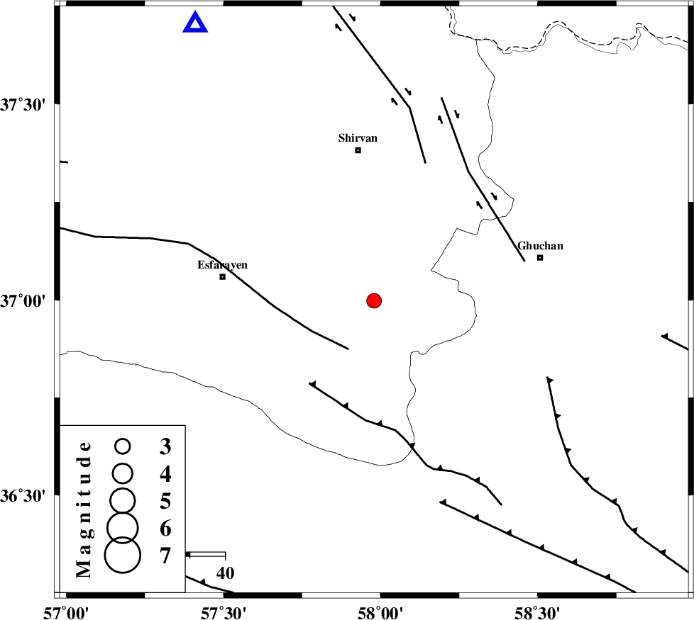
Magnitude |
:3 |
| Date & Time (UTC) | 2025-03-25 03:07:32.1 |
| Date & Time (Local) | 1404/1/5 06:37:32.1 |
| Location | Lat:36.998 Lon: 57.979 |
| Region | Khorasan(north) Province, 43 km South of Shirvan |
Nearest Cities |
|
| 10 km North of Bam, Khorasan(north) Province | |
| 24 km South of Maviyan, Khorasan(center) Province | |
| 24 km South West of Chari, Khorasan(center) Province | |
| 26 km South of Geliyan, Khorasan(north) Province | |
| 28 km North West of Yangi qaleh, Khorasan(center) Province | |
| Depth | 12 km |
| Agency | |
Faults within 150 km: |
|
| ESFARAYEN_F (Length: 111 km) , Distance to epicenter: 16 km | |
| RIVAND_F (Length: 70 km) , Distance to epicenter: 30 km | |
| BAGHAN_GERMAB_F (Length: 79 km) , Distance to epicenter: 42 km | |
| Number of Phases | 6 |
| RMS | 0.4 |
| Number of Stations | 6 |
| Error in Latitude | >37 km |
| Error in Longitude | 58 km |
| Error in Depth | 12 km |
Download waveform in seisan format
to download seisan software Click here
to access information about IIEES stations Click here
Amplitude | ||||||||
| UID | Agency | Station | Component | Amplitude | Period | Arrival Time | Proccessing Time | Signal Clip |
| 197871 | IIEES SC | MRVT | Z | 0.4 | 1 | 2025-03-25 03:08:02 | 2025-04-13 05:09:00 | n |
| 197872 | IIEES SC | TABS | Z | 0.02 | 1 | 2025-03-25 03:08:27 | 2025-04-13 05:09:00 | n |
| 197873 | IIEES SC | SHRT | Z | 0.04 | 1 | 2025-03-25 03:08:33 | 2025-04-13 05:09:00 | n |
Phase | ||||||||||||
| Agency | Station | Component | Phase Type | Phase Quality | First Motion | Observed Arrival Time | Time Residual | Loc. Flag | Input Weight | Distance | Azimuth | |
| IIEES SC | BJRD | Z | EPg | E | 2025-03-25 03:07:47 | -0.5 | y | 0 | 93 | 327 | ||
| IIEES SC | MRVT | Z | EPg | E | 2025-03-25 03:08:02 | 0.7 | y | 0 | 183 | 294 | ||
| IIEES SC | SHRO | Z | EPn | E | 2025-03-25 03:08:08 | 2.7 | n | 4 | 208 | 238 | ||
| IIEES SC | TABS | Z | EPn | E | 2025-03-25 03:08:27 | -0.2 | y | 0 | 380 | 192 | ||
| IIEES SC | SHRT | Z | EPn | E | 2025-03-25 03:08:33 | 0.1 | y | 0 | 427 | 151 | ||
| IIEES SC | YZKH | Z | EPn | E | 2025-03-25 03:08:50 | -4.3 | n | 4 | 598 | 211 | ||