
Magnitude |
:3 |
| Date & Time (UTC) | 2025-03-05 05:52:55.9 |
| Date & Time (Local) | 1403/12/15 09:22:55.9 |
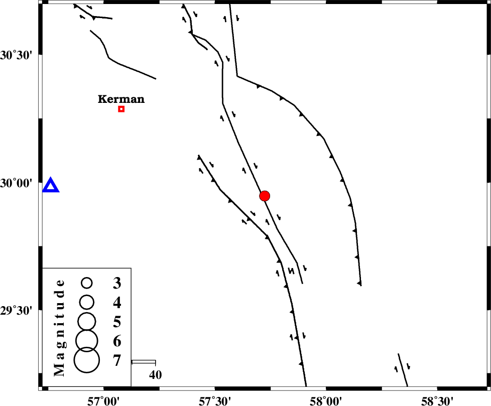
| Location | Lat:29.947 Lon: 57.723 |
| Region | Kerman Province, 73 km South-East of Kerman |
Nearest Cities |
|
| 10 km North of Golbaft, Kerman Province | |
| 21 km South East of Jushan, Kerman Province | |
| 32 km South East of Sirch, Kerman Province | |
| 42 km North West of Geshit, Kerman Province | |
| 43 km South East of Mahan, Kerman Province | |
| Depth | 12 km |
| Agency | |
Faults within 150 km: |
|
| GOLBAF_SIRCH_F (Length: 114 km) , Distance to epicenter: 15 km | |
| GOWK_F (Length: 152 km) , Distance to epicenter: 18 km | |
| SHAHDAD_F (Length: 108 km) , Distance to epicenter: 34 km | |
| Number of Phases | 7 |
| RMS | 0.4 |
| Number of Stations | 7 |
| Error in Latitude | >5.9 km |
| Error in Longitude | 5.9 km |
| Error in Depth | 810 km |
Download waveform in seisan format
to download seisan software Click here
to access information about IIEES stations Click here
Amplitude | ||||||||
| UID | Agency | Station | Component | Amplitude | Period | Arrival Time | Proccessing Time | Signal Clip |
| 197359 | IIEES SC | ZHSF | Z | 0.06 | 1 | 2025-03-05 05:53:41 | 2025-03-08 09:55:00 | n |
| 197360 | IIEES SC | TABS | Z | 0.03 | 1 | 2025-03-05 05:53:54 | 2025-03-08 09:55:00 | n |
| 197361 | IIEES SC | IRSR | Z | 0.02 | 1 | 2025-03-05 05:53:59 | 2025-03-08 09:55:00 | n |
| 197362 | IIEES SC | SHRT | Z | 0.03 | 1 | 2025-03-05 05:54:02 | 2025-03-08 09:55:00 | n |
Phase | ||||||||||||
| Agency | Station | Component | Phase Type | Phase Quality | First Motion | Observed Arrival Time | Time Residual | Loc. Flag | Input Weight | Distance | Azimuth | |
| IIEES SC | KRBR | Z | EPg | E | 2025-03-05 05:53:31 | 19 | n | 4 | 93 | 272 | ||
| IIEES SC | BSRN | Z | EPn | E | 2025-03-05 05:53:24 | -12.2 | n | 4 | 261 | 31 | ||
| IIEES SC | ZHSF | Z | EPn | E | 2025-03-05 05:53:41 | 0.4 | y | 0 | 297 | 97 | ||
| IIEES SC | YZKH | Z | EPn | E | 2025-03-05 05:53:54 | 0.2 | y | 0 | 403 | 312 | ||
| IIEES SC | TABS | Z | EPn | E | 2025-03-05 05:53:54 | -0.7 | y | 0 | 414 | 352 | ||
| IIEES SC | IRSR | Z | EPn | E | 2025-03-05 05:53:59 | -0.3 | y | 0 | 451 | 137 | ||
| IIEES SC | SHRT | Z | EPn | E | 2025-03-05 05:54:02 | -0.2 | y | 0 | 477 | 31 | ||