
Magnitude |
:3.1 |
| Date & Time (UTC) | 2021-10-02 23:14:06.6 |
| Date & Time (Local) | 1400/7/11 02:44:06.6 |
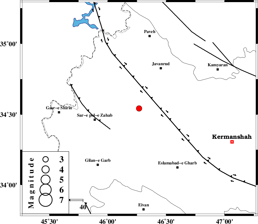
| Location | Lat:34.543 Lon: 46.268 |
| Region | Kermanshah Province, 36 km -East of Sar-e pol-e zahab |
Nearest Cities |
|
| 7 km North of Zavleh olia, Kermanshah Province | |
| 16 km South of Mirabad, Kermanshah Province | |
| 22 km North West of Gahvareh, Kermanshah Province | |
| 22 km South East of Qolqoleh, Kermanshah Province | |
| 23 km North East of Rijab, Kermanshah Province | |
| Depth | 10 km |
| Agency | |
Faults within 150 km: |
|
| HZF4 (Length: 492 km) , Distance to epicenter: 14 km | |
| MFF8 (Length: 48 km) , Distance to epicenter: 28 km | |
| SARTAKHT_F (Length: 78 km) , Distance to epicenter: 66 km | |
| Number of Phases | 7 |
| RMS | 0.5 |
| Number of Stations | 7 |
| Error in Latitude | >2.3 km |
| Error in Longitude | 2.3 km |
| Error in Depth | 8.5 km |
Download waveform in seisan format
to download seisan software Click here
to access information about IIEES stations Click here
Amplitude | ||||||||
| UID | Agency | Station | Component | Amplitude | Period | Arrival Time | Proccessing Time | Signal Clip |
| 165478 | IIEES SC | SRSL | Z | 0.6 | 1 | 2021-10-02 23:14:39 | 2021-10-03 05:35:00 | n |
| 165479 | IIEES SC | MAHB | Z | 0.3 | 1 | 2021-10-02 23:14:45 | 2021-10-03 05:35:00 | n |
| 165480 | IIEES SC | GTMR | Z | 0.05 | 1 | 2021-10-02 23:14:57 | 2021-10-03 05:35:00 | n |
Phase | ||||||||||||
| Agency | Station | Component | Phase Type | Phase Quality | First Motion | Observed Arrival Time | Time Residual | Loc. Flag | Input Weight | Distance | Azimuth | |
| IIEES SC | ILBA | Z | EPg | E | 2021-10-02 23:14:24 | 0.3 | y | 0 | 102 | 183 | ||
| IIEES SC | SRSL | Z | EPn | E | 2021-10-02 23:14:39 | 0.3 | y | 0 | 200 | 338 | ||
| IIEES SC | MAHB | Z | EPn | E | 2021-10-02 23:14:45 | -0.9 | y | 0 | 252 | 348 | ||
| IIEES SC | QABG | Z | EPn | E | 2021-10-02 23:14:56 | 0.4 | y | 0 | 329 | 67 | ||
| IIEES SC | GTMR | Z | EPn | E | 2021-10-02 23:14:57 | -0.6 | y | 0 | 350 | 131 | ||
| IIEES SC | MRD | Z | EPn | E | 2021-10-02 23:15:15 | 3 | n | 4 | 466 | 354 | ||
| IIEES SC | CHTH | Z | EPn | E | 2021-10-02 23:15:17 | 4.8 | n | 4 | 467 | 71 | ||