
Magnitude |
:2.9 |
| Date & Time (UTC) | 2019-12-02 05:17:05.7 |
| Date & Time (Local) | 1398/9/11 08:47:05.7 |
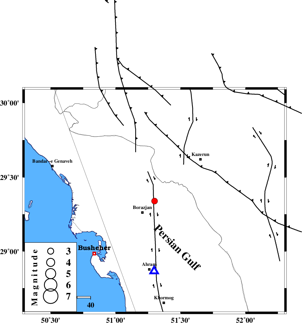
| Location | Lat:29.34 Lon: 51.3 |
| Region | Bushehr Province, 13 km of Borazjan |
Nearest Cities |
|
| 10 km of Dalki, Bushehr Province | |
| 12 km East of Nazar aqa, Bushehr Province | |
| 13 km North of Borazjan, Bushehr Province | |
| 18 km East of Saedabad, Bushehr Province | |
| 19 km North of Sarkareh, Bushehr Province | |
| Depth | 14 km |
| Agency | |
Faults within 150 km: |
|
| ZFF3 (Length: 125 km) , Distance to epicenter: 7 km | |
| BORAZJAN_F (Length: 168 km) , Distance to epicenter: 8 km | |
| KAZERUN_F (Length: 96 km) , Distance to epicenter: 35 km | |
| Number of Phases | 8 |
| RMS | 0.6 |
| Number of Stations | 8 |
| Error in Latitude | >3 km |
| Error in Longitude | 0 km |
| Error in Depth | 8 km |
Download waveform in seisan format
to download seisan software Click here
to access information about IIEES stations Click here
Amplitude | ||||||||
| UID | Agency | Station | Component | Amplitude | Period | Arrival Time | Proccessing Time | Signal Clip |
| 149195 | IIEES SC | AHRM | Z | 58 | 1 | 2019-12-02 05:17:30 | 2019-12-03 10:06:00 | n |
| 149196 | IIEES SC | KLNJ | Z | 110 | 1 | 2019-12-02 05:18:03 | 2019-12-03 10:06:00 | n |
| 149197 | IIEES SC | GHIR | Z | 15 | 1 | 2019-12-02 05:18:02 | 2019-12-03 10:06:00 | n |
| 149198 | IIEES SC | NASN | Z | 8.3 | 1 | 2019-12-02 05:18:30 | 2019-12-03 10:06:00 | n |
Phase | ||||||||||||
| Agency | Station | Component | Phase Type | Phase Quality | First Motion | Observed Arrival Time | Time Residual | Loc. Flag | Input Weight | Distance | Azimuth | |
| IIEES SC | AHRM | N | IS | I | 2019-12-02 05:17:22 | 0.6 | y | 55 | 181 | |||
| IIEES SC | AHRM | Z | IP | I | 2019-12-02 05:17:14 | -0.5 | y | 55 | 181 | |||
| IIEES SC | KLNJ | N | IS | I | 2019-12-02 05:18:00 | 0.8 | y | 189 | 9 | |||
| IIEES SC | KLNJ | Z | IP | I | 2019-12-02 05:17:36 | 0.4 | y | 189 | 9 | |||
| IIEES SC | GHIR | N | IS | I | 2019-12-02 05:18:03 | 0.4 | y | 200 | 125 | |||
| IIEES SC | GHIR | Z | IP | I | 2019-12-02 05:17:38 | -0.3 | y | 200 | 125 | |||
| IIEES SC | NASN | N | IS | I | 2019-12-02 05:18:47 | -0.9 | y | 411 | 21 | |||
| IIEES SC | NASN | Z | IP | I | 2019-12-02 05:18:03 | -0.9 | y | 411 | 21 | |||