
Magnitude |
:2.9 |
| Date & Time (UTC) | 2018-11-27 18:04:03.4 |
| Date & Time (Local) | 1397/9/6 21:34:03.4 |
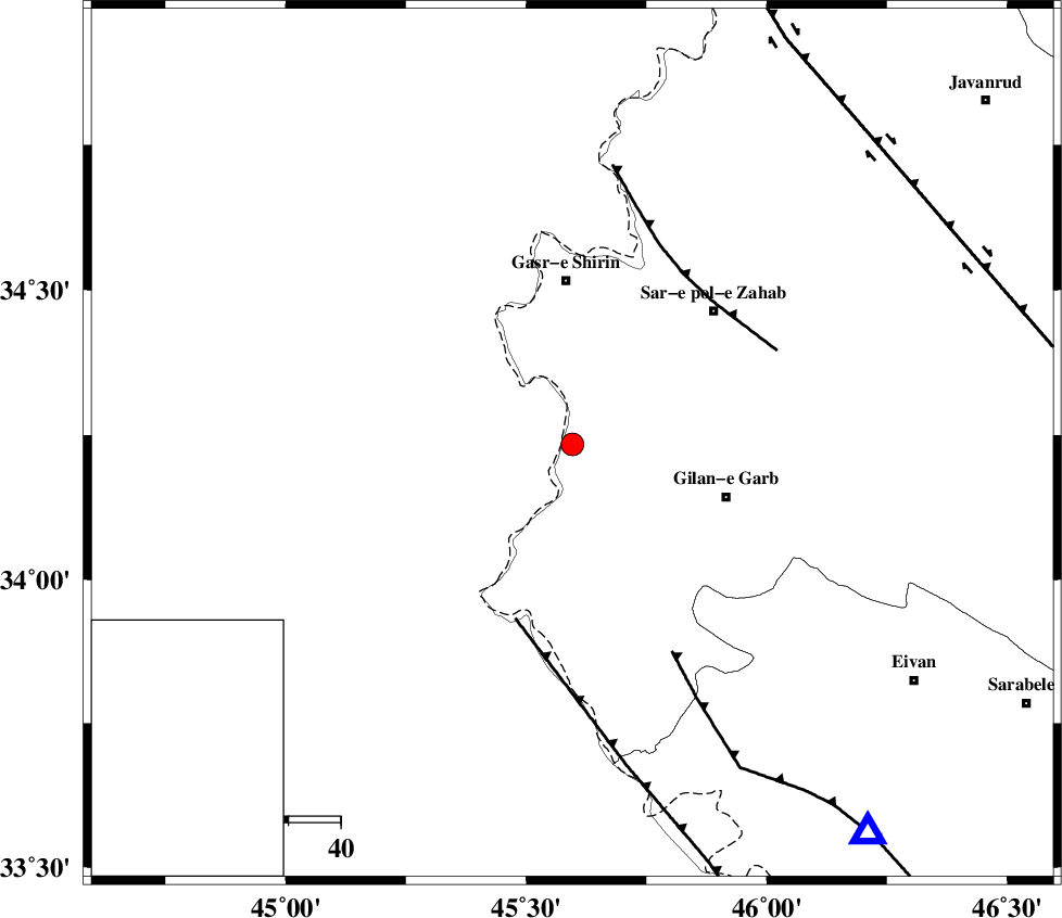
| Location | Lat:34.234 Lon: 45.596 |
| Region | Kermanshah Province, 31 km South of Qasr-E-Shirin |
Nearest Cities |
|
| 22 km South East of Khosravi, Kermanshah Province | |
| 23 km South of Seyyed sohrab, Kermanshah Province | |
| 26 km West of Chub baghan, Kermanshah Province | |
| 31 km North West of Gilan-E-Gharb, Kermanshah Province | |
| 31 km South of Qasr-E-Shirin, Kermanshah Province | |
| Depth | 14 km |
| Agency | |
Faults within 150 km: |
|
| ZFF4 (Length: 128 km) , Distance to epicenter: 35 km | |
| MFF8 (Length: 48 km) , Distance to epicenter: 38 km | |
| MFF7 (Length: 99 km) , Distance to epicenter: 44 km | |
| Number of Phases | 5 |
| RMS | 0 |
| Number of Stations | 3 |
| Error in Latitude | >1.2 km |
| Error in Longitude | 2.3 km |
| Error in Depth | 4.4 km |
Download waveform in seisan format
to download seisan software Click here
to access information about IIEES stations Click here
Amplitude | ||||||||
| UID | Agency | Station | Component | Amplitude | Period | Arrival Time | Proccessing Time | Signal Clip |
| 138787 | IIEES | ILBA | N | 431.7 | 0.57 | 2018-11-27 18:04:35 | 2018-11-28 11:07:00 | n |
| 138788 | IIEES | ILBA | E | 391.9 | 0.62 | 2018-11-27 18:04:38 | 2018-11-28 11:07:00 | n |
| 138789 | IIEES | SNGE | N | 120.9 | 0.61 | 2018-11-27 18:05:10 | 2018-11-28 11:07:00 | n |
Phase | ||||||||||||
| Agency | Station | Component | Phase Type | Phase Quality | First Motion | Observed Arrival Time | Time Residual | Loc. Flag | Input Weight | Distance | Azimuth | |
| IIEES | ILBA | Z | Pg | E | 2018-11-27 18:04:18 | 0 | y | 88.1 | 140 | |||
| IIEES | SNGE | Z | Pg | E | 2018-11-27 18:04:34 | -0.08 | y | 187 | 59 | |||
| IIEES | SNGE | N | Sg | E | 2018-11-27 18:04:56 | 0.04 | y | 187 | 59 | |||
| IIEES | SRSL | Z | Pn | E | 2018-11-27 18:04:38 | 0.05 | y | 220 | 356 | |||
| IIEES | SRSL | N | Sg | E | 2018-11-27 18:05:05 | -0.02 | y | 220 | 356 | |||