
Magnitude |
:2.5 |
| Date & Time (UTC) | 2017-03-12 16:35:51.8 |
| Date & Time (Local) | 1395/12/22 20:05:51.8 |
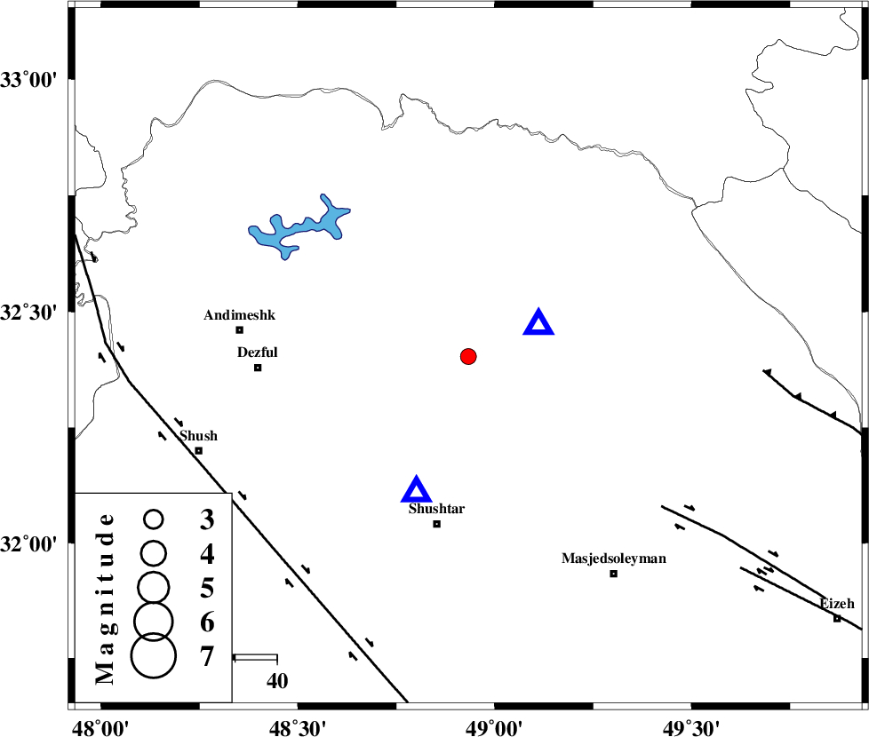
| Location | Lat:32.403 Lon: 48.933 |
| Region | Khoozestan Province, 17 km -West of Lali |
Nearest Cities |
|
| 14 km of Sardasht, Khoozestan Province | |
| 17 km North West of Lali, Khoozestan Province | |
| 21 km North East of Gatvand, Khoozestan Province | |
| 23 km North West of Jaefarabad, Khoozestan Province | |
| 24 km North of Samaleh, Khoozestan Province | |
| Depth | 14 km |
| Agency | |
Faults within 150 km: |
|
| DEZFUL_EMBAYMENT (Length: 228 km) , Distance to epicenter: 15 km | |
| MFF2 (Length: 205 km) , Distance to epicenter: 29 km | |
| BALARUD_F_Z2 (Length: 58 km) , Distance to epicenter: 32 km | |
| Number of Phases | 6 |
| RMS | 0.2 |
| Number of Stations | 4 |
| Error in Latitude | >5.2 km |
| Error in Longitude | 5.3 km |
| Error in Depth | 7.2 km |
Download waveform in seisan format
to download seisan software Click here
to access information about IIEES stations Click here
Amplitude | ||||||||
| UID | Agency | Station | Component | Amplitude | Period | Arrival Time | Proccessing Time | Signal Clip |
| 113963 | IIEES | KHMZ | N | 51 | 0.52 | 2017-03-12 16:36:45 | 2017-03-13 06:17:00 | n |
| 113964 | IIEES | KHMZ | E | 57.1 | 0.52 | 2017-03-12 16:36:45 | 2017-03-13 06:17:00 | n |
| 113965 | IIEES | ASAO | N | 25.3 | 0.55 | 2017-03-12 16:37:09 | 2017-03-13 06:17:00 | n |
| 113966 | IIEES | ASAO | E | 32.6 | 0.28 | 2017-03-12 16:37:12 | 2017-03-13 06:17:00 | n |
| 113967 | IIEES | GHVR | E | 13.3 | 0.38 | 2017-03-12 16:37:27 | 2017-03-13 06:17:00 | n |
| 113968 | IIEES | SNGE | N | 8.8 | 0.45 | 2017-03-12 16:37:30 | 2017-03-13 06:17:00 | n |
| 113969 | IIEES | SNGE | E | 7 | 0.67 | 2017-03-12 16:37:34 | 2017-03-13 06:17:00 | n |
Phase | ||||||||||||
| Agency | Station | Component | Phase Type | Phase Quality | First Motion | Observed Arrival Time | Time Residual | Loc. Flag | Input Weight | Distance | Azimuth | |
| IIEES | KHMZ | Z | Pg | E | 2017-03-12 16:36:20 | -0.09 | y | 177 | 33 | |||
| IIEES | KHMZ | N | Sg | E | 2017-03-12 16:36:42 | 0.26 | y | 177 | 33 | |||
| IIEES | ASAO | Z | Pn | E | 2017-03-12 16:36:31 | 0.01 | y | 259 | 23 | |||
| IIEES | ASAO | N | Sg | E | 2017-03-12 16:37:04 | -0.22 | y | 259 | 23 | |||
| IIEES | GHVR | Z | Pn | E | 2017-03-12 16:36:38 | -0.05 | y | 315 | 42 | |||
| IIEES | SNGE | Z | Pn | E | 2017-03-12 16:36:41 | 0.09 | y | 333 | 334 | |||