
Magnitude |
:2.7 |
| Date & Time (UTC) | 2017-01-23 01:21:18.0 |
| Date & Time (Local) | 1395/11/4 04:51:18.0 |
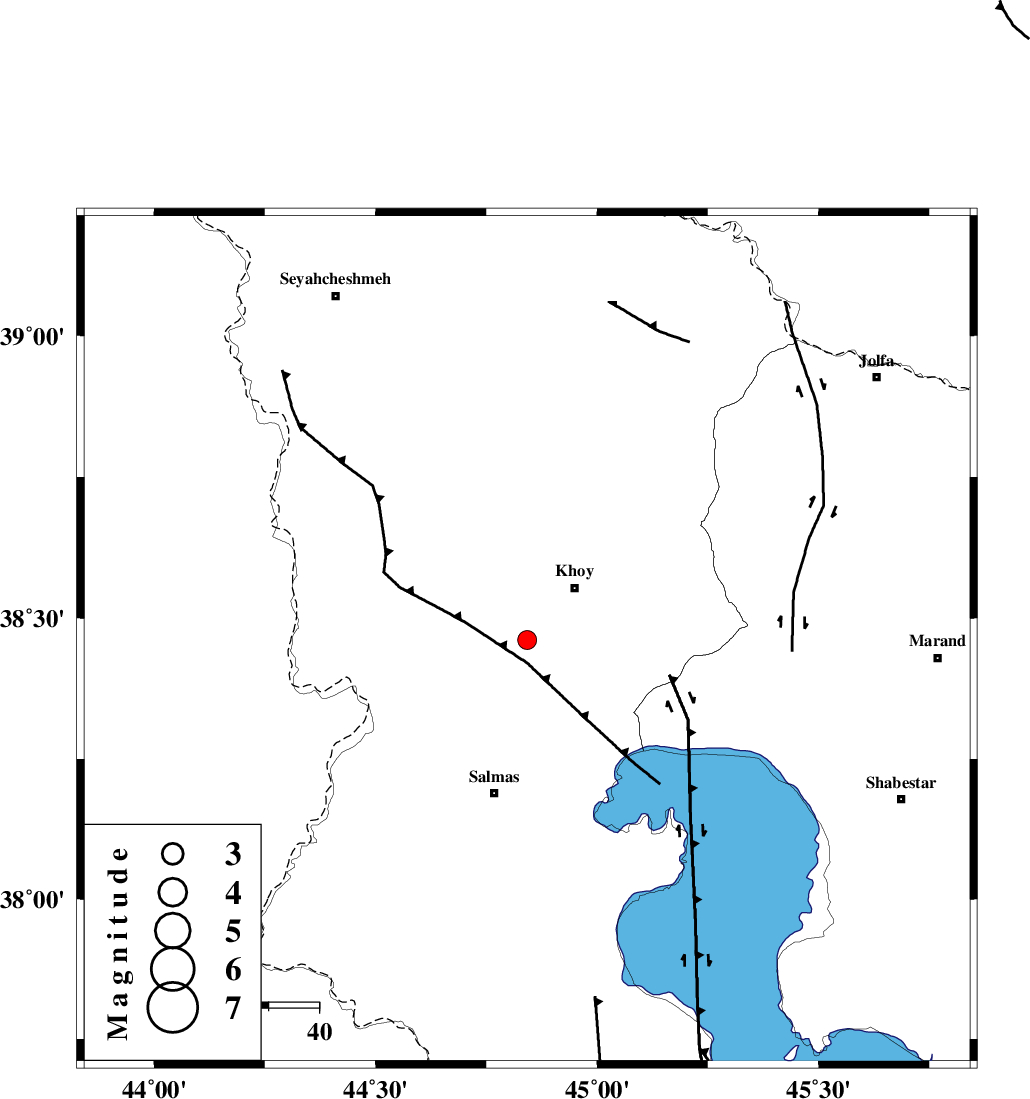
| Location | Lat:38.461 Lon: 44.842 |
| Region | Azarbaijan Gharbi Province, 14 km -West of Khoy |
Nearest Cities |
|
| 7 km North of Quruq, Azarbaijan Gharbi Province | |
| 10 km of Beyk sofla, Azarbaijan Gharbi Province | |
| 14 km West of Khoy, Azarbaijan Gharbi Province | |
| 17 km North West of Dizaj diz, Azarbaijan Gharbi Province | |
| 18 km North of Saylab, Azarbaijan Gharbi Province | |
| Depth | 14 km |
| Agency | |
Faults within 150 km: |
|
| KHOY (Length: 100 km) , Distance to epicenter: 13 km | |
| N_TABRIZ_F3 (Length: 66 km) , Distance to epicenter: 18 km | |
| SALMAS (Length: 20 km) , Distance to epicenter: 35 km | |
| Number of Phases | 5 |
| RMS | 0.1 |
| Number of Stations | 3 |
| Error in Latitude | >6.5 km |
| Error in Longitude | 3.8 km |
| Error in Depth | 8.8 km |
Download waveform in seisan format
to download seisan software Click here
to access information about IIEES stations Click here
Amplitude | ||||||||
| UID | Agency | Station | Component | Amplitude | Period | Arrival Time | Proccessing Time | Signal Clip |
| 112513 | IIEES | MAKU | N | 144.9 | 0.45 | 2017-01-23 01:21:53 | 2017-01-23 05:04:00 | n |
| 112514 | IIEES | GRMI | E | 68.9 | 0.31 | 2017-01-23 01:22:35 | 2017-01-23 05:04:00 | n |
| 112515 | IIEES | GRMI | N | 27.1 | 0.47 | 2017-01-23 01:22:38 | 2017-01-23 05:04:00 | n |
Phase | ||||||||||||
| Agency | Station | Component | Phase Type | Phase Quality | First Motion | Observed Arrival Time | Time Residual | Loc. Flag | Input Weight | Distance | Azimuth | |
| IIEES | MAKU | Z | Pg | E | 2017-01-23 01:21:35 | -0.02 | y | 100 | 352 | |||
| IIEES | GRMI | Z | Pn | E | 2017-01-23 01:21:59 | 0.1 | y | 269 | 81 | |||
| IIEES | GRMI | E | Sg | E | 2017-01-23 01:22:33 | -0.01 | y | 269 | 81 | |||
| IIEES | ZNJK | Z | Pn | E | 2017-01-23 01:22:14 | -0.09 | y | 393 | 119 | |||
| IIEES | SNGE | Z | Pn | E | 2017-01-23 01:22:24 | 4.11 | n | 4 | 436 | 148 | ||