
Magnitude |
:3.1 |
| Date & Time (UTC) | 2015-11-11 11:20:00.4 |
| Date & Time (Local) | 1394/8/20 14:50:00.4 |
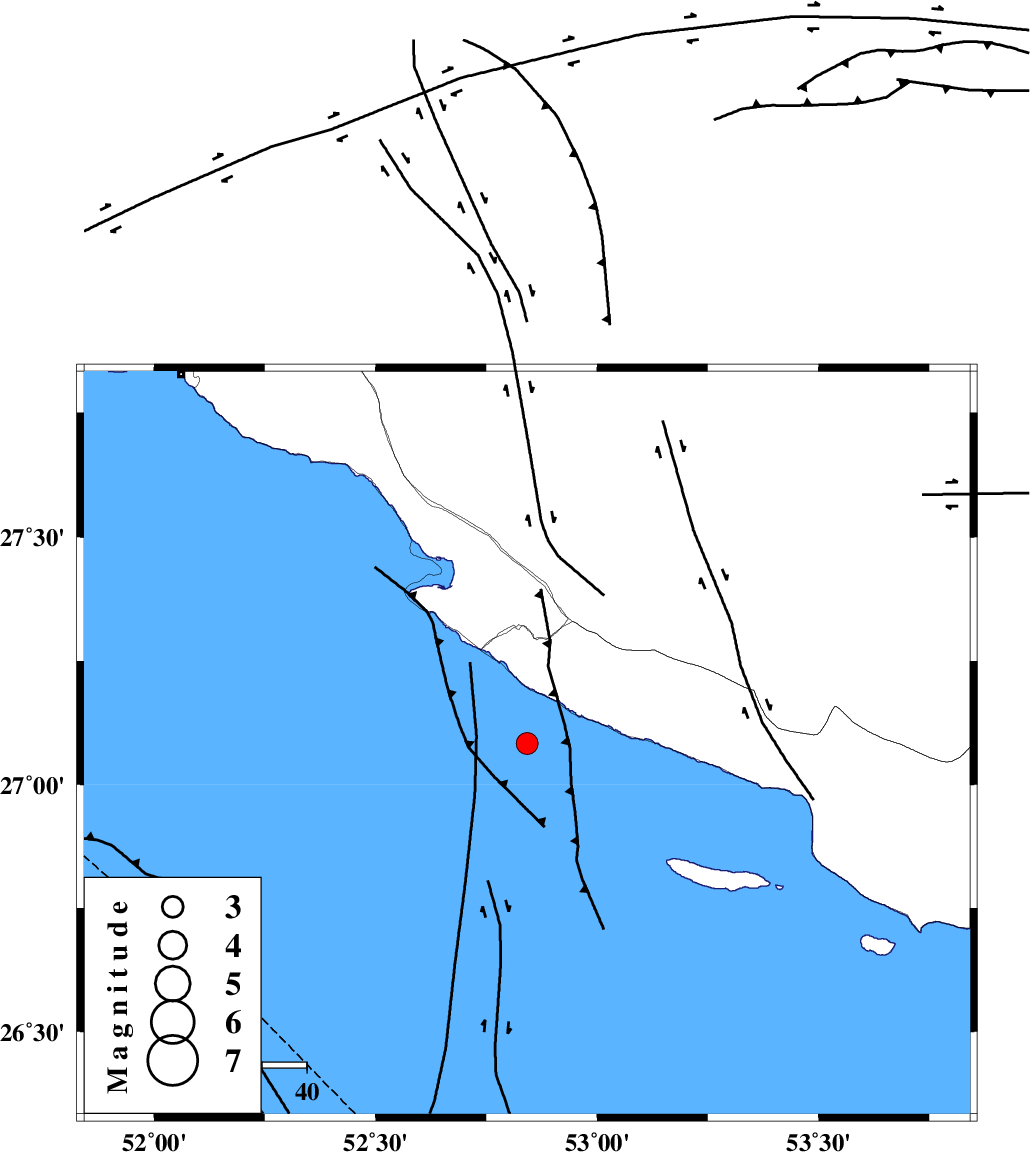
| Location | Lat:27.083 Lon: 52.842 |
| Region | Persian Gulf, 52 km South of Mehr |
Nearest Cities |
|
| 31 km South of Chah-e mobarak, Bushehr Province | |
| 42 km South West of Khoozi, Fars Province | |
| 42 km South West of Lamerd, Fars Province | |
| 49 km South East of Bandar-e asaluyeh, Bushehr Province | |
| 52 km South of Mehr, Fars Province | |
| Depth | 15 km |
| Agency | |
Faults within 150 km: |
|
| MFF3 (Length: 292 km) , Distance to epicenter: 25 km | |
| ZFF1 (Length: 165 km) , Distance to epicenter: 98 km | |
| MFF1 (Length: 180 km) , Distance to epicenter: 119 km | |
| Number of Phases | 6 |
| RMS | 0.1 |
| Number of Stations | 6 |
| Error in Latitude | >9.1 km |
| Error in Longitude | 1.4 km |
| Error in Depth | 0 km |
Download waveform in seisan format
to download seisan software Click here
to access information about IIEES stations Click here
Amplitude | ||||||||
| UID | Agency | Station | Component | Amplitude | Period | Arrival Time | Proccessing Time | Signal Clip |
| 102312 | IIEES | KRBR | E | 17.2 | 0.59 | 2015-11-11 11:22:20 | 2015-11-14 10:28:00 | n |
| 102313 | IIEES | KRBR | N | 18 | 0.72 | 2015-11-11 11:22:38 | 2015-11-14 10:28:00 | n |
Phase | ||||||||||||
| Agency | Station | Component | Phase Type | Phase Quality | First Motion | Observed Arrival Time | Time Residual | Loc. Flag | Input Weight | Distance | Azimuth | |
| IIEES | AHRM | Z | Pn | E | 2015-11-11 11:20:38 | 0.01 | y | 249 | 323 | |||
| IIEES | KRBR | Z | Pn | E | 2015-11-11 11:21:10 | 0.19 | y | 500 | 49 | |||
| IIEES | YZKH | Z | Pn | E | 2015-11-11 11:21:24 | -0.05 | y | 612 | 16 | |||
| IIEES | BSRN | Z | P | E | 2015-11-11 11:21:49 | -0.12 | y | 815 | 47 | |||
| IIEES | ZHSF | Z | P | E | 2015-11-11 11:21:50 | -0.14 | y | 827 | 68 | |||
| IIEES | TABS | Z | P | E | 2015-11-11 11:21:51 | -0.07 | y | 836 | 28 | |||